GemVoyage Team • World
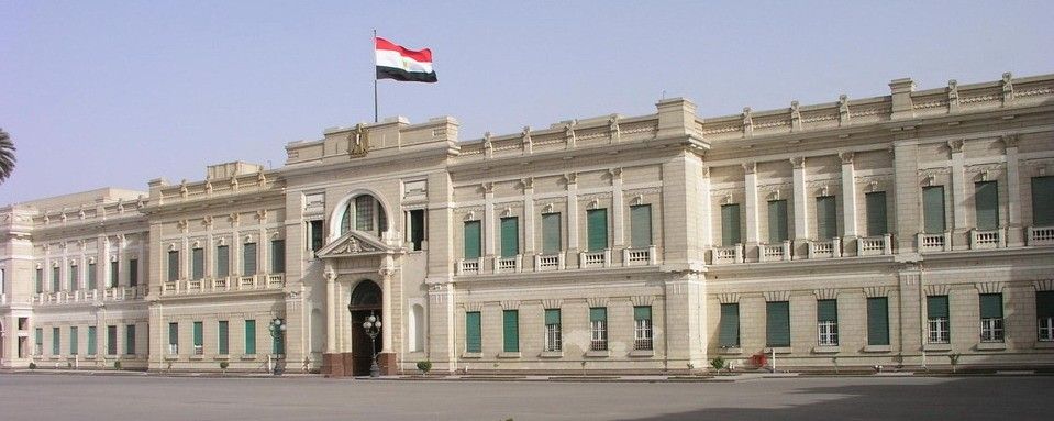
The Abdeen Palace Museum (متحف قصر عابدين) is one of Cairo’s most magnificent historical landmarks and a must-see for lovers of history, architecture, and royal treasures. Constructed in the late 19th century under the orders of Khedive Ismail, the palace served as the royal residence for Egypt’s rulers from 1874 until 1952, when the monarchy was abolished. Today, it is both a functioning presidential palace and a museum complex that showcases the grandeur of Egypt’s royal past.
What makes Abdeen Palace unique is its dual function: part of the palace remains an official seat of the presidency, while the museum sections are open to the public. The museum houses vast collections of weapons, medals, diplomatic gifts, rare manuscripts, and even an elaborate array of clocks and watches. The Arms Museum and Medals Museum are particular highlights, revealing not just Egypt’s history but also its connections to other nations.
A lesser-known fact is that Abdeen Palace is one of the largest palaces in the world, with over 500 rooms, though only a fraction is open to visitors. Another interesting detail is that the palace survived several periods of turmoil, including the 1952 revolution, and still stands as a symbol of both Egypt’s royal heritage and its modern political history.
Abdeen Palace is located in Downtown Cairo, the capital of Egypt, in the Cairo Governorate. It sits in the Abdeen district, east of Tahrir Square, making it accessible from many of Cairo’s central landmarks.
To get there, visitors can take a taxi, Uber, or public transport to the Abdeen area. The nearest metro stop is Mohamed Naguib Station on Cairo’s Metro Line 2, from which the palace is a short walk. Because Cairo traffic can be hectic, traveling by metro or planning visits during less busy hours is recommended.
The Abdeen Palace Museum is more than just a royal residence—it is a treasure house of Egypt’s modern history. With its lavish architecture, rare collections, and continuing role in national life, it provides visitors with a deeper understanding of Egypt’s transition from monarchy to republic. For anyone exploring Cairo, Abdeen Palace offers a captivating mix of politics, culture, and opulence.
1. When was Abdeen Palace built?
It was commissioned by Khedive Ismail and completed in 1874, designed with European architectural influences.
2. How many museums are inside Abdeen Palace?
The palace contains several specialized museums, including the Arms Museum, Medals Museum, Silver Museum, and Historical Documents Museum.
3. Is the palace still used today?
Yes, part of Abdeen Palace is still used by the Egyptian Presidency for official functions, while the museum sections are open to the public.
4. How much time should I plan for a visit?
Plan at least 2–3 hours to explore the various museum wings at a comfortable pace.
5. Is photography allowed inside?
Photography rules vary; in many areas it is restricted or requires a permit. Always check before taking photos.
6. What’s the best way to get there?
The metro is a convenient choice, with Mohamed Naguib Station nearby. Otherwise, taxis and ride-hailing services are widely available in Cairo.
Discover more hidden gems you might love.
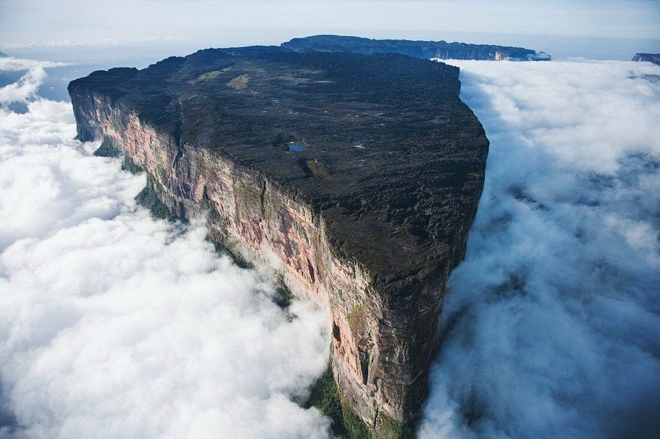
Gran Sabana
## Description Mount Roraima is a striking tabletop tepui — a flat-topped sandstone mesa — rising abruptly from the Gran Sabana plateau along the Venezuela–Brazil–Guyana border. Immensely atmospheric, its sheer cliffs and mist-shrouded summit inspired Arthur Conan Doyle’s The Lost World; the summit supports endemic plants and sculptural rock formations carved by erosion and persistent cloud. Trekking to Roraima’s summit is an otherworldly journey through shifting ecosystems: savanna, tepui foothills, cloud forests and alien rocky plateaus dotted with carnivorous plants and primitive flora. What makes Roraima singular is its biology and geology: tepuis act as ecological islands where species evolved in isolation, resulting in endemic flora and fauna found nowhere else. The plateau’s quartzite sandstone and erosional patterns carve shallow sinkholes and intricate channels that collect rainwater, forming microhabitats. Visitors encounter oddly-shaped boulders, deep natural cisterns and ephemeral pools that support plant communities adapted to thin soils and high rainfall. Beyond science, the experience is sensory: mist and cloud sweep across the summit, light transforms the slick rock faces, and nights on the plateau can be cold and silvery. For many, the trek to Roraima — along river crossings, open savanna and jungle gullies — delivers a sense of expeditionary travel; the route requires multi-day camping and careful logistical planning. ## Location Mount Roraima sits in the Gran Sabana region of southeastern Venezuela (Canaima National Park), at the tri-border with Guyana and Brazil. Most treks begin from the Venezuelan side, with popular access points around Paraitepuy or via Canaima; flights to Canaima followed by drives and river transfers are common. Organizing a Roraima expedition requires permits, an experienced guide and coordination for river logistics and camping equipment. Given its border location, some itineraries approach Roraima from Guyana — these routes are less common for international visitors but viable for those with appropriate travel documents and local arrangements. Venezuelan-side treks are the classic choice and usually include boat transfers, vehicle rides across savanna, and multiple days of trekking culminating with the scramble onto the plateau. ## Tips - **Book with experienced operators:** Choose accredited guides or operators who handle permits, river logistics, and camping gear. The plateau’s remoteness demands reliable local knowledge and safety planning. - **Fitness and acclimatization:** The trek is physically demanding, often involving long days of walking across uneven terrain, river crossings and carrying a daypack while guides transport communal gear. Conditioning with endurance hikes and strength training helps. - **Pack for extremes:** Expect heavy rain, intense sun at low elevations, muddy jungle stretches and cool winds on the summit. Waterproof layers, quick-dry clothing, high-traction trekking boots, gaiters, and a warm down layer for nights on the plateau are essential. - **Protect electronics and paper maps:** Use dry bags for sleeping gear and phone/ camera protection; quick access to waterproof maps or offline GPS tracking improves navigation in jungle and savanna. - **Leave no trace:** Camp on durable surfaces, pack out all waste, and avoid disturbing endemic plants on the plateau. The tepui ecosystem is delicate and regenerates slowly. - **Plan for altitude and weather:** The plateau can be cold and windy; thermal layers for nighttime and sun protection for daytime are both necessary. Bring a reliable headlamp and spare batteries for early starts or late arrivals. - **Permits and border considerations:** Verify permit requirements, carry appropriate identification, and confirm whether your route crosses national borders — passports and travel documents must be in order. ## Conclusion Mount Roraima offers a genuine expedition into a primeval landscape where geology and isolated evolution create surreal scenery. For adventurous travelers, the tepui’s summit is both a physical challenge and a revelation in biodiversity. The trek is unforgettable for those who embrace its remoteness — mist-wrapped cliffs, otherworldly rock formations, and night skies uncluttered by light pollution create one of South America’s most singular natural experiences. ## FAQ - **Q: How long is the trek to Roraima’s summit?** A: Typical treks last 6–8 days round-trip, depending on route and pace. Some itineraries are longer if they include extra side excursions in the Gran Sabana or additional borderside logistics. - **Q: Is the trek technical or suitable for beginners?** A: The trek is non-technical in terms of climbing gear but is physically demanding and involves uneven, slippery surfaces and river crossings. Experienced guides can support less-experienced hikers, but a baseline of good fitness is important. - **Q: What permits or documents are required?** A: Permits vary by entry point and country. When approaching from Venezuela, arrange permits via a licensed operator; if approaching from Guyana or Brazil, confirm local regulations. Always carry valid ID and passport when near border areas. - **Q: When is the best time to trek Roraima?** A: The drier months (roughly December to April) are generally more manageable, but weather on tepuis can be unpredictable year-round. Avoid peak rainy periods when trails become more treacherous. - **Q: What wildlife and plant life should I expect?** A: Expect specialized endemic plants, carnivorous species like pitcher plants in microhabitats, and unique lichens and mosses on the summit. Larger wildlife is mostly absent on the plateau, but wildlife sightings are possible in the lowland savanna and rainforest approaches. - **Q: Is camping on the plateau comfortable?** A: Camping is rustic: bring a four-season or high-quality three-season tent and warm sleeping gear. Nighttime temperatures can drop sharply and winds can be strong. ## Links - [Mount Roraima — Wikipedia](https://en.wikipedia.org/wiki/Mount_Roraima)
GemVoyage Team • World
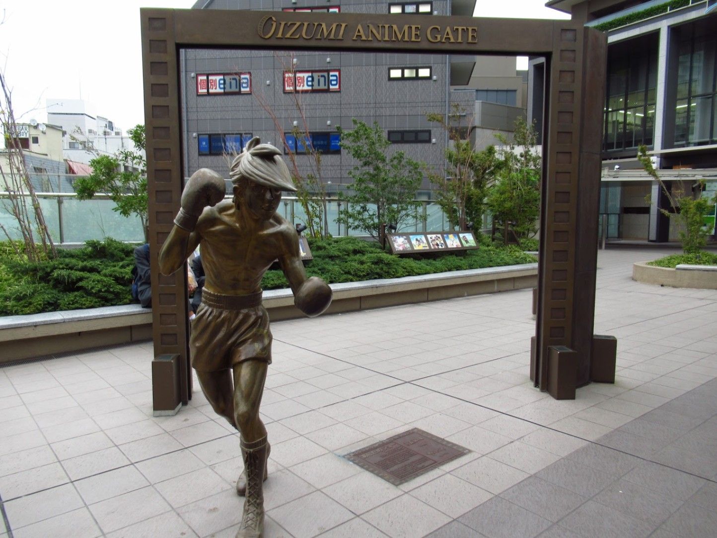
Tokyo
## Description **Ōizumi Anime Gate (大泉アニメゲート)** is a compact but culturally significant open-air attraction located in western Tokyo, celebrating the birthplace of Japan’s anime industry. Rather than being a museum or theme park, it is a **symbolic gateway** marked by life-size bronze statues of iconic anime characters, integrated directly into a normal urban environment. The site honors Ōizumi’s role as the home of **Toei Animation**, one of the most influential studios in anime history. What makes Ōizumi Anime Gate unique is its **casual accessibility**. There is no ticket, no enclosed space, and no structured route. Visitors encounter statues of characters such as Astro Boy, Sally the Witch, Tiger Mask, and Cyborg 009 as part of the daily streetscape. This reflects how deeply anime is woven into Japanese culture not as a niche interest, but as a shared cultural language. A little-known fact is that Ōizumi was the location of Japan’s **first full-scale animation studio**, established in the 1950s, which helped transition animation from experimental shorts into serialized television content. Another lesser-known detail is that the statues are intentionally spread around the station area rather than grouped together, encouraging visitors to explore the neighborhood rather than treating the site as a single photo stop. Ōizumi Anime Gate appeals not only to anime fans but also to travelers interested in **cultural origins**. It provides context for how anime evolved from a local industry into a global phenomenon, all while remaining firmly rooted in an ordinary Tokyo district. ## Location **Country:** Japan **Region:** Kantō **City:** Tokyo **Ward:** Nerima **Area:** Ōizumi The Anime Gate is centered around **Ōizumi-gakuen Station**, a suburban hub on the Seibu Ikebukuro Line. ### How to Get There * **By train:** * Take the **Seibu Ikebukuro Line** from Ikebukuro Station to **Ōizumi-gakuen Station**. The ride takes about 15–20 minutes. * **By bus:** * Local buses connect Ōizumi with other parts of Nerima and western Tokyo. * **By taxi:** * Convenient but unnecessary, as the station area is compact and walkable. * **On foot:** * Once at Ōizumi-gakuen Station, all statues are reachable within a short walking loop. ## Tips * **Download a statue map:** The figures are spread out, and a map helps ensure you don’t miss any. * **Visit during daylight:** The statues are outdoors and best photographed in natural light. * **Respect the neighborhood:** This is a residential and commuter area, not a theme park. * **Combine with local cafés:** Ōizumi has small cafés and bakeries popular with residents. * **Anime knowledge helps but isn’t required:** Informational plaques explain each character’s significance. * **Great short stop:** Ideal as a half-day visit combined with other western Tokyo neighborhoods. ## Conclusion Ōizumi Anime Gate is a modest but meaningful destination that honors the roots of Japanese animation in a way that feels authentic and unforced. By blending iconic characters into everyday urban life, it offers visitors a grounded perspective on how anime became a cornerstone of modern Japanese culture. ## FAQ **1. Is Ōizumi Anime Gate a museum?** No. It is an open-air installation of statues spread around the station area. **2. Is there an entrance fee?** No. The site is completely free to visit. **3. How long does a visit take?** About **30–60 minutes**, depending on how many statues you explore. **4. Is it suitable for children?** Yes. The area is safe, walkable, and family-friendly. **5. Do I need to be an anime fan to enjoy it?** Not necessarily. The site also appeals to visitors interested in Japanese cultural history. **6. Are there shops selling anime merchandise?** Not directly at the site, but nearby Tokyo districts offer extensive anime shopping options. ## Links * [Tokyo tourism official site](https://www.gotokyo.org)
GemVoyage Team • World
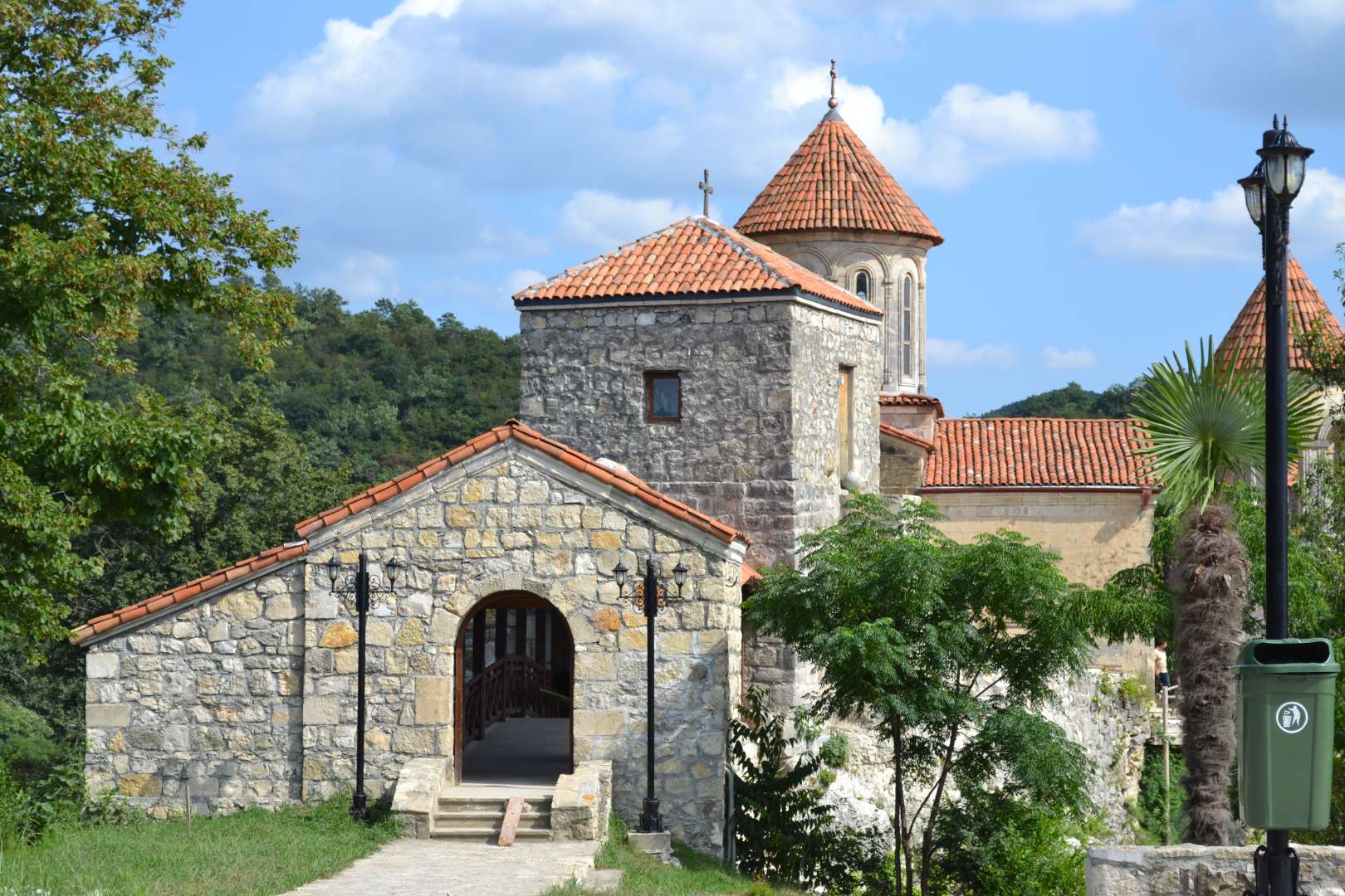
Kutaisi
## Description Motsameta Monastery is a hidden gem nestled in the hills of western Georgia, just outside the city of Kutaisi. This 8th-century Georgian Orthodox monastery is revered not only for its spiritual significance but also for its breathtaking location—perched on a cliff above the winding Tskaltsitela River, whose name translates to “Red Water.” The river earned this name from a legend tied to the monastery’s origins: two noble brothers, David and Constantine Mkheidze, were martyred during an Arab invasion, and their blood is said to have turned the river red. The monastery, whose name means “Place of the Martyrs,” was built to honor these brothers, and their relics are preserved in the crypt beneath the church. According to local lore, crawling under the crypt and making a wish may lead to it coming true—a tradition that continues to draw pilgrims and curious visitors alike. What makes Motsameta truly unique is its intimate scale and serene atmosphere. Unlike the more famous Gelati Monastery nearby, Motsameta feels like a quiet retreat, surrounded by dense Colchic forest and echoing with the sounds of nature. The monastery’s architecture is classic Georgian, with arched windows, stone walls, and a red-tiled roof that glows warmly in the sunlight. A little-known fact: there’s a legend of a secret tunnel connecting Motsameta to Gelati Monastery, used during times of war to protect monks and relics. Though the tunnel remains a mystery, it adds to the allure and mystique of the site. ## Location Motsameta Monastery is located in **Georgia**, in the **Imereti Region**, near the city of **Kutaisi**. It’s situated about 6 kilometers northeast of the city center, making it easily accessible for a half-day trip. ### How to Get There: - **By Car**: From Kutaisi, it’s a 15-minute drive through scenic countryside. Taxis and rental cars are readily available. - **By Foot**: Adventurous travelers can hike from Gelati Monastery to Motsameta through forest trails, enjoying panoramic views along the way. - **By Tour**: Many local tour operators offer combined visits to Motsameta and Gelati, often including historical commentary and transportation. The road to the monastery winds through forested hills, offering glimpses of the river and valley below—a journey as rewarding as the destination. ## Tips for Visitors To make the most of your visit to Motsameta Monastery, consider these helpful tips: - **Visit in the Morning or Late Afternoon**: These times offer the best lighting for photography and a more peaceful atmosphere. - **Wear Comfortable Shoes**: The path to the monastery includes uneven terrain and steps, so sturdy footwear is recommended. - **Respect Local Customs**: Modest dress is appreciated, especially when entering the church. Women may be asked to cover their heads. - **Bring a Camera**: The views from the cliff and the monastery’s architecture are incredibly photogenic. - **Combine with Gelati Monastery**: Visiting both sites offers a fuller picture of Georgia’s medieval religious heritage. - **Make a Wish**: Don’t miss the chance to crawl under the crypt and take part in the local tradition. ## Conclusion Motsameta Monastery is a tranquil and spiritually rich destination that blends history, legend, and natural beauty. Whether you're drawn by its sacred relics, its dramatic setting, or its quiet charm, this monastery offers a deeply rewarding experience just outside Kutaisi. ## FAQ **1. Is there an entrance fee to visit Motsameta Monastery?** No, entry is free for all visitors. **2. How long does it take to visit the monastery?** A typical visit lasts 1–2 hours, including time to explore the grounds and enjoy the views. **3. Can I visit Motsameta and Gelati Monasteries in one day?** Yes, they are close to each other and often visited together. **4. Is the monastery accessible year-round?** Yes, though the forest trail may be slippery in winter or after rain. **5. Are guided tours available?** Yes, local guides and tour companies offer historical tours that include Motsameta. **6. Is the monastery suitable for children?** Yes, but supervision is recommended due to the cliffside location and uneven paths. ## Links - [Motsameta Monastery – Georgia Travel Guide](https://georgia.travel/motsameta-monastery) - [Motsameta Monastery – Wikipedia Overview](https://en.wikipedia.org/wiki/Motsameta_monastery) - [Motsameta Monastery – Imereti Tourism Info](https://georgia.to/en/places-to-go/imereti/motsameta-monastery/)
GemVoyage Team • World
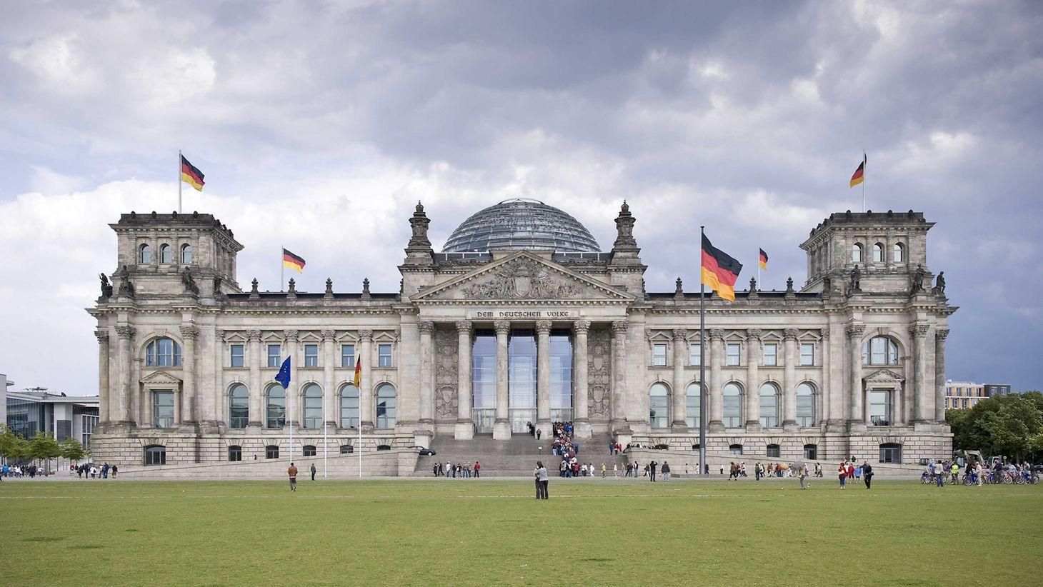
Berlin
## Description The **Bundestag Building**, officially known as the **Reichstagsgebäude**, stands as one of the most significant landmarks in **Berlin** and a powerful symbol of **Germany’s turbulent history and democratic rebirth**. Combining monumental architecture with modern transparency, it serves today as the seat of the **German Federal Parliament (Deutscher Bundestag)** — and one of the most visited government buildings in the world. Originally designed by **architect Paul Wallot** and completed in **1894**, the building was intended to house the **Imperial Diet of the German Empire**. Its Neo-Renaissance façade, crowned by a grand central dome, reflected the pride and ambition of a newly unified Germany. However, the Reichstag’s history mirrors that of the nation itself — one of struggle, destruction, and renewal. In **1933**, the infamous **Reichstag fire** severely damaged the building, and it was later left in ruins during World War II. After decades of neglect during the Cold War, when Berlin was divided, the Reichstag stood near the border between East and West as a haunting reminder of Germany’s fractured identity. Following reunification, the Bundestag was **rebuilt and transformed** under the vision of **British architect Sir Norman Foster**, who completed his renovation in **1999**. The centerpiece of this reconstruction is the **modern glass dome**, an architectural marvel that symbolizes **transparency and accessibility in government**. Visitors can ascend the spiraling ramp inside the dome to enjoy **panoramic views of Berlin**, while looking down into the debating chamber below — a literal reflection of the people’s oversight over their elected representatives. A lesser-known fact is that during reconstruction, thousands of **historic graffiti inscriptions** left by Soviet soldiers in 1945 were carefully preserved on interior walls, serving as poignant reminders of the city’s wartime history. Another fascinating detail is that the **solar-powered dome** is part of an advanced energy-efficient system that makes the Bundestag one of the world’s greenest government buildings. ## Location The **Bundestag Building** is located in the **government district (Regierungsviertel)** of **Berlin**, **Germany**, near the **Brandenburg Gate** and along the **River Spree**. **Address:** Platz der Republik 1, 11011 Berlin, Germany To get there: * **By U-Bahn:** Take **U5** to **Bundestag Station**, located directly beside the building. * **By S-Bahn:** The **Berlin Hauptbahnhof (Main Station)** is about a **10-minute walk** away. * **By bus:** Routes **100** and **200** stop nearby at **Reichstag/Bundestag**. * **By foot or bike:** It’s an easy walk from the **Brandenburg Gate** or the **Tiergarten** park. ## Tips * **Book your visit in advance:** Entry to the dome and terrace is **free**, but **online registration** is required through the Bundestag’s official website due to high demand. * **Bring ID:** You’ll need a valid photo ID to enter the building for security reasons. * **Visit the dome at sunset or night:** The views of Berlin’s skyline — including the Brandenburg Gate and the Fernsehturm (TV Tower) — are spectacular after dark. * **Take the guided tour:** Learn about German history, architecture, and politics from official Bundestag guides. Tours are offered in multiple languages. * **Dress comfortably:** There’s a bit of walking and ramp climbing involved when visiting the dome. * **Combine with nearby attractions:** The **Brandenburg Gate**, **Memorial to the Murdered Jews of Europe**, and **Tiergarten** are all within walking distance. * **Photography:** Cameras are allowed — the dome’s glass reflections and city views make it a photographer’s dream. ## Conclusion The **Bundestag Building (Reichstag)** is more than a seat of government — it’s a living monument to **Germany’s journey from empire to democracy**. From its grand 19th-century origins through wartime destruction and postwar division, to its renewal as a transparent and sustainable parliament, the building embodies the nation’s resilience and progress. Visiting the Bundestag is both a **historical and symbolic experience**, offering a glimpse into the past and a view toward the future — quite literally through its luminous glass dome overlooking Berlin. ## FAQ **1. What is the difference between the Reichstag and the Bundestag?** “Reichstag” refers to the **historic building** itself, while “Bundestag” refers to **Germany’s federal parliament**, which now meets inside the Reichstag building. **2. When was the Reichstag building completed?** It was completed in **1894**, heavily damaged during World War II, and **fully restored and reopened in 1999** after reunification. **3. Who redesigned the building after reunification?** The **British architect Sir Norman Foster** led the reconstruction, adding the iconic glass dome. **4. Is it free to visit?** Yes, **entry to the Bundestag, dome, and terrace is free**, but advance **registration** is required for security reasons. **5. Can you visit the parliamentary chamber?** Yes, guided tours include access to the chamber when sessions are not in progress. Visitors can also attend plenary sessions by prior arrangement. **6. When is the best time to visit?** The **evening** is ideal for breathtaking views of Berlin at sunset, but daytime visits offer clearer views of the cityscape. **7. What are the opening hours?** The dome is usually open daily from **8 a.m. to midnight**, with last entry around **10 p.m.** (check the official site for seasonal variations). ## Links * [Official Bundestag Visitor Registration](https://www.bundestag.de/en/visittheBundestag/dome/registration-245686)
GemVoyage Team • World
Moscow
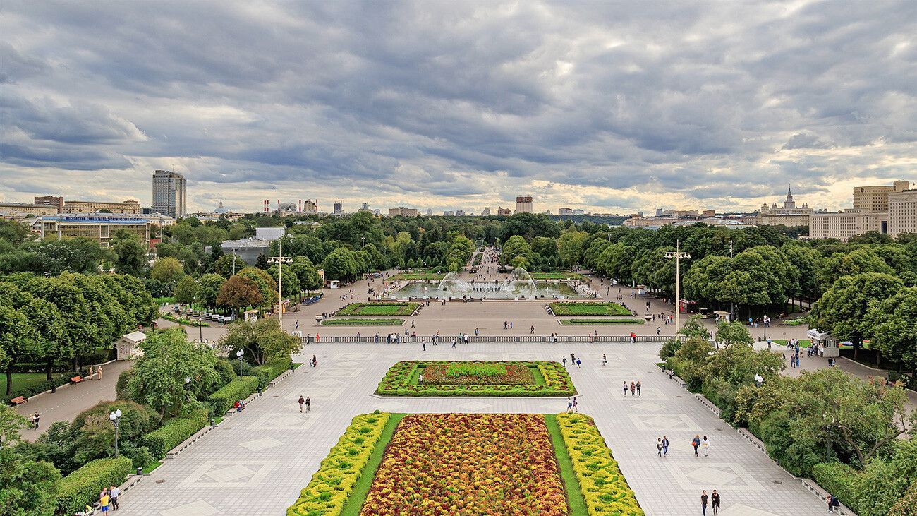
## Description Gorky Park is one of Moscow’s most recognizable public spaces, but its importance goes beyond fame. It functions as a major urban park, a leisure destination, and a symbol of how Moscow’s public life has evolved over time. For visitors, it offers a broad, flexible experience that can include walking paths, riverside views, outdoor activities, cultural programming, seasonal events, and simply the pleasure of being in a lively city park with enough scale to feel substantial. It is a park that can fill a few hours without demanding a rigid plan. One of the reasons Gorky Park remains so appealing is that it balances energy and openness. It is popular with residents, but it still gives travelers space to breathe. A lesser-known fact is that the park has been reinterpreted several times across different periods of Russian history, which means its identity reflects changing ideas about public recreation and city life. Another detail many visitors notice only after arriving is how different the park can feel depending on the season: summer brings crowds, bikes, and long evenings outdoors, while winter can transform parts of the park into a much quieter and more atmospheric space. The park’s value for tourists lies in its versatility. You can come here for exercise, a casual walk, coffee, a river view, or a break from heavy sightseeing. You can also use it as a transition point between more formal cultural landmarks and more relaxed urban exploration. In a city as large as Moscow, that role matters. Gorky Park offers a kind of public relief, a place where the scale softens and the city becomes easier to inhabit on foot. It is also a good example of how a park can be both local and iconic. Residents use it as everyday space, while travelers see it as an essential Moscow destination. That overlap is usually a sign of a worthwhile attraction. ## Location Gorky Park is located in central Moscow, Russia, along the Moskva River. Its riverfront position gives it a scenic edge and makes it easy to combine with surrounding cultural sites or waterfront walks. The park is very much part of the city’s main urban fabric, so it is convenient to reach even if you are staying in a busy central district. The easiest way to get there is by Moscow Metro, followed by a short walk depending on which entrance or section you want to use. Public transport is usually the smartest approach because it avoids traffic and places you directly within the park’s broader central network. Once inside, the grounds are meant to be explored on foot, by bike, or by simply moving from one area to another at your own pace. Because Gorky Park is so flexible, the best plan is often to use it as part of a longer city day rather than as a standalone objective. It pairs naturally with museum visits, riverfront exploration, or a relaxed afternoon in central Moscow. ## Tips Choose the season carefully if you can. Gorky Park changes dramatically across the year, and each season creates a different mood. Leave room for wandering. The park is best when you allow yourself to drift rather than trying to cover every section. Bring a bike or rent one if you want to cover more ground and experience the park like a local. If you are there in warm weather, plan for food and drinks so you can stay longer and enjoy the river atmosphere. Check for events or temporary installations, since the park often has more happening than a first-time visitor may expect. ## Conclusion Gorky Park is one of Moscow’s most adaptable and enjoyable public spaces, combining relaxation, scenery, and urban life in one central location. It is an essential stop for visitors who want to see how Muscovites use the city for leisure. ## FAQ ### Is Gorky Park worth visiting in winter? Yes. The atmosphere changes, but winter can be especially beautiful and calm. ### How long should I spend there? At least 1 to 3 hours, depending on whether you are walking, biking, or attending an event. ### Is it family-friendly? Very much so. The park is a major public leisure space with broad appeal. ### Can I combine it with other Moscow sights? Yes. Its central location makes it easy to pair with museums, river views, or other city-center attractions. ## Links - [Gorky Park](https://russiable.com/gorky-park-moscow/)
GemVoyage Team • World
Antalya
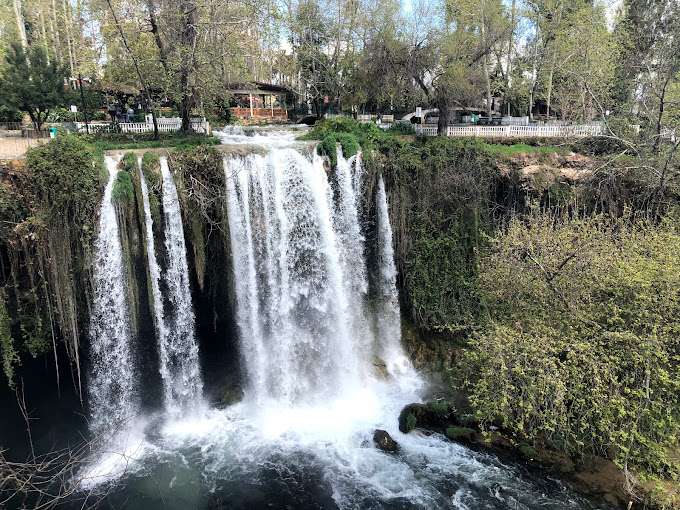
## Description Düden Waterfalls in Antalya are among Turkey’s most captivating natural attractions, offering a dramatic blend of lush greenery, cascading water, and coastal beauty. Fed by the Düden River, these waterfalls are divided into two distinct sites: the Upper Düden Waterfall (Yukarı Düden Şelalesi) and the Lower Düden Waterfall (Aşağı Düden Şelalesi). Each offers a unique experience, making them a must-visit for nature lovers, photographers, and anyone seeking a peaceful escape from the city. The Upper Düden Waterfall is nestled in a tranquil park setting, where water tumbles 20 meters into a cave-lined basin surrounded by trees and walking paths. Visitors can explore behind the waterfall through a natural cave, offering a rare perspective of the rushing water from within. The park also features picnic areas, shaded benches, and small cafés, making it ideal for a relaxed afternoon. The Lower Düden Waterfall, by contrast, is a dramatic spectacle where the river plunges 40 meters off a cliff directly into the Mediterranean Sea. Located in Düden Park in the Lara district, this waterfall is best viewed from the observation terrace or from the sea on a boat tour. The sight of the water crashing into the ocean, often accompanied by rainbows formed in the mist, is unforgettable. A little-known fact: the water that feeds the Upper Düden Waterfall originates from a karstic source and travels underground for nearly 11 miles before resurfacing. Another interesting detail is that the Lower Düden Waterfall is also known locally as Karpuzkaldıran Şelalesi, which translates to “watermelon lifter waterfall,” a name tied to local folklore. ## Location Düden Waterfalls are located in **Turkey**, in the **Antalya Province**, within the **city of Antalya**. The Upper Düden Waterfall is situated in the Kepez district, while the Lower Düden Waterfall is located in the Lara district, near the coast. ### How to Get There - **Upper Düden Waterfall**: From Antalya city center, take a taxi or drive about 10 kilometers northeast to the Kepez district. Public buses (such as bus number VC57) also serve the area. - **Lower Düden Waterfall**: Located about 8 kilometers southeast of the city center, it can be reached by taxi, car, or public buses like KL08 or LF09. Boat tours from Kaleiçi Marina also offer views from the sea. Both sites are easily accessible and can be visited in a single day. ## Tips - **Visit Both Sites**: Each waterfall offers a distinct experience—don’t miss the chance to see both. - **Bring a Camera**: The mist, cliffs, and greenery make for stunning photos, especially at sunset. - **Wear Comfortable Shoes**: Trails around the Upper Düden Waterfall can be uneven and slippery. - **Take a Boat Tour**: Viewing the Lower Düden Waterfall from the sea offers a unique and dramatic perspective. - **Pack Snacks or Picnic Supplies**: The Upper Düden site has picnic areas perfect for a leisurely meal. - **Check the Weather**: Spring and early summer offer the best conditions for photography and boat tours. ## Conclusion Düden Waterfalls are a natural gem in Antalya, offering two distinct yet equally mesmerizing experiences. Whether you’re exploring caves behind a forest waterfall or watching water plunge into the Mediterranean, this destination promises beauty, tranquility, and unforgettable views. ## FAQ **1. Is there an entrance fee to Düden Waterfalls?** Yes. The Upper Düden Waterfall charges a small entrance fee (around 70 TL), while the Lower Düden Waterfall is free to visit. **2. Can I swim near the waterfalls?** Swimming is not permitted near the waterfalls due to safety concerns, but nearby beaches offer swimming opportunities. **3. Are the waterfalls open year-round?** Yes, both sites are open throughout the year, though hours may vary seasonally. **4. Are the waterfalls suitable for children?** Yes, both locations are family-friendly, with safe paths and picnic areas. **5. How long should I plan for a visit?** Allow 1–2 hours for each site, or a half-day if visiting both. **6. Are there guided tours available?** Yes, many local tour operators offer packages that include transportation, guided visits, and boat tours. ## Links - [Official Düden Waterfalls Website](https://dudenwaterfalls.com/)
GemVoyage Team • World

Comments