GemVoyage Team • World
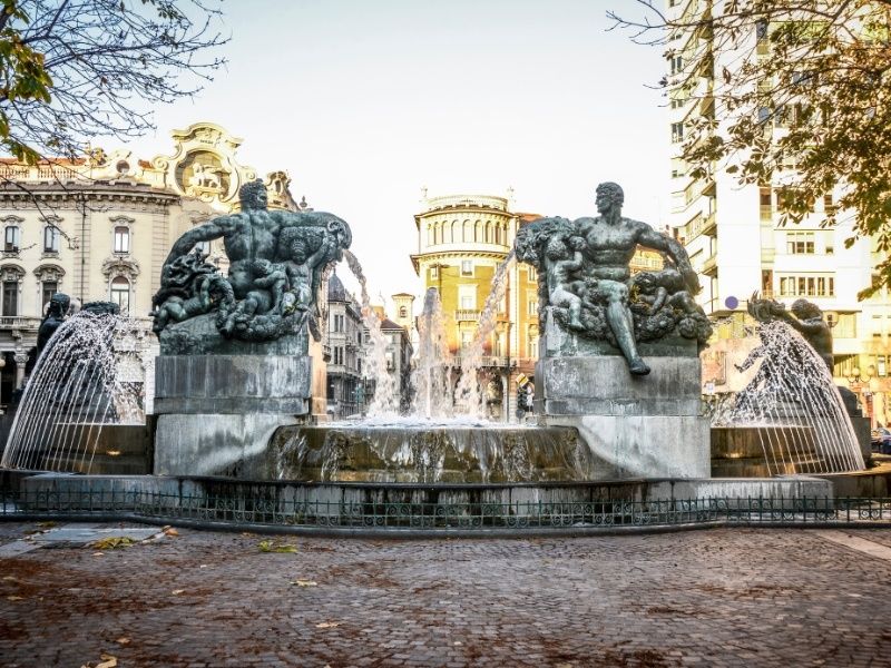
Piazza Solferino is one of Turin’s most elegant and historically significant squares, offering a refined blend of architecture, green spaces, and local life. Located in the city center, the square serves as a calm yet vibrant meeting point where residents and visitors alike come to stroll, relax, or enjoy a coffee nearby. Unlike some of Turin’s more monumental piazzas, Piazza Solferino feels intimate and lived-in, making it an excellent place to experience the city at a slower pace.
What makes Piazza Solferino unique is its layered history. The square is named after the Battle of Solferino (1859), a key event in Italian unification, and it stands close to sites connected to important political and cultural moments. A lesser-known fact is that the nearby area played a role in the birth of the Red Cross movement, inspired by the aftermath of the Battle of Solferino. Another interesting detail is the presence of subtle architectural transitions around the square, reflecting Turin’s shift from baroque influences to more modern urban planning during the 19th and early 20th centuries.
With its central gardens, mature trees, and surrounding cafés and offices, Piazza Solferino offers a peaceful contrast to the busier shopping streets just steps away.
Piazza Solferino is located in Italy, in the Piedmont region, within the city of Turin (Torino). It sits in the historic center, between Corso Re Umberto and Via Cernaia, making it a natural crossroads for both locals and visitors.
The square is easy to reach on foot from many major attractions, including Piazza Castello and Via Roma. Public transportation is also convenient, with multiple bus and tram lines stopping nearby. The closest metro station is Re Umberto on Line 1, which is just a short walk away. For visitors staying in central Turin, Piazza Solferino is often best reached by walking, allowing you to enjoy the surrounding streets and architecture.
Piazza Solferino is a refined and welcoming urban space that reflects Turin’s history, elegance, and everyday rhythm. Its central location, historical significance, and peaceful atmosphere make it a rewarding stop for anyone exploring the city.
Is Piazza Solferino worth visiting for tourists?
Yes, especially for those interested in local atmosphere, history, and architecture rather than major monuments alone.
Are there restaurants and cafés nearby?
Yes, the surrounding streets offer a wide range of cafés, restaurants, and bars.
How much time should I spend at Piazza Solferino?
Most visitors spend 20 to 40 minutes, though it can easily be longer if you stop for coffee or relaxation.
Is Piazza Solferino family-friendly?
Yes, the open space and central garden make it suitable for families and casual visits.
Does the square host events?
Occasionally, small cultural or community events take place, particularly during warmer months.
Discover more hidden gems you might love.
Yokohama
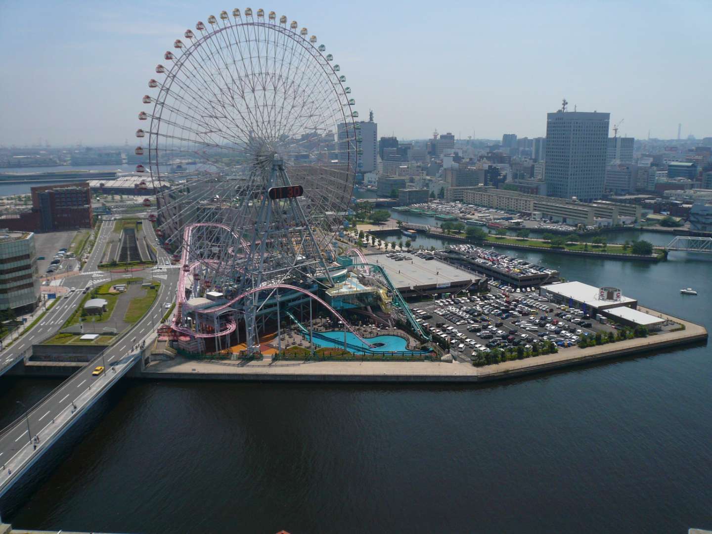
## Description Cosmo World in Yokohama is a vibrant urban amusement park that blends thrilling rides, family-friendly attractions, and waterfront views into one unforgettable experience. Located in the heart of the Minato Mirai 21 district, this compact yet dynamic park is best known for its iconic Ferris wheel, Cosmo Clock 21, which once held the title of the world’s largest Ferris wheel with a clock. Towering over the city skyline, it offers panoramic views of Yokohama Bay and the surrounding urban landscape, especially stunning at night when the wheel lights up in dazzling colors. The park is divided into three distinct zones: the Wonder Amuse Zone, Burano Street Zone, and Kids Carnival Zone. Each area caters to different age groups and interests. The Wonder Amuse Zone features high-adrenaline rides like the Diving Coaster: Vanish, a roller coaster that plunges into a tunnel beneath a pool of water. The Burano Street Zone offers quirky attractions such as mirror mazes and haunted houses, while the Kids Carnival Zone is perfect for younger children with gentle rides and arcade games. A little-known fact: Cosmo World originated from the Yokohama Exotic Showcase in 1989, and the Ferris wheel was part of a temporary exhibition before becoming a permanent fixture. Another unique detail is that admission to the park is free—you only pay for the rides you choose to enjoy, making it an accessible destination for all budgets. ## Location Cosmo World is located in **Japan**, in the **Kanagawa Prefecture**, within the city of **Yokohama**. It sits in the **Minato Mirai 21 district**, a modern waterfront area known for its shopping, entertainment, and cultural attractions. ### How to Get There - **By Train**: The park is a short walk from Minato Mirai Station (Minato Mirai Line) and Sakuragicho Station (JR Keihin-Tohoku Line and Yokohama Municipal Subway Blue Line). - **By Bus**: Several local buses stop near the Minato Mirai area. - **By Foot**: If you're exploring the waterfront, Cosmo World is easily accessible from nearby attractions like Landmark Tower and the Yokohama Red Brick Warehouse. - **By Car**: Parking is available in nearby lots, though public transport is recommended due to traffic and convenience. Its central location makes it an easy addition to any Yokohama itinerary. ## Tips - **Visit in the Evening**: The illuminated Ferris wheel and waterfront views are especially magical after sunset. - **Buy a Ride Pass**: While entry is free, purchasing a ride pass can save money if you plan to try multiple attractions. - **Check Height Restrictions**: Some rides have strict height and age requirements, so check ahead if visiting with children. - **Avoid Peak Hours**: Weekends and holidays can be crowded. Weekday afternoons are generally quieter. - **Bring Cash**: Some ticket booths and vending machines may not accept cards. - **Combine with Nearby Attractions**: Pair your visit with a trip to CupNoodles Museum or a harbor cruise for a full day of fun. ## Conclusion Cosmo World in Yokohama is a compact yet exhilarating amusement park that offers something for everyone—from heart-pounding roller coasters to scenic Ferris wheel rides. Its waterfront location, free entry, and diverse attractions make it a must-visit for families, couples, and solo travelers alike. ## FAQ **1. Is there an entrance fee to Cosmo World?** No, admission is free. You only pay for the rides you choose to go on. **2. What are the operating hours?** Typically, the park operates from 11:00 AM to 8:00 PM, but hours may vary seasonally or due to weather. **3. Is Cosmo World suitable for young children?** Yes, the Kids Carnival Zone is designed specifically for younger visitors. **4. Can I buy tickets online?** Ride tickets are generally purchased on-site. Some packages may be available through travel agencies. **5. Is the Ferris wheel wheelchair accessible?** Yes, Cosmo Clock 21 is accessible for wheelchair users. **6. Are food and drinks allowed inside the park?** Outside food and drinks are not permitted, but there are cafés and vending machines within the park. ## Links - [Cosmo World Official Website](https://cosmoworld.jp/about/?lang=en) - [Yokohama Cosmo World – Wikipedia Overview](https://en.wikipedia.org/wiki/Yokohama_Cosmo_World)
GemVoyage Team • World
Chicago
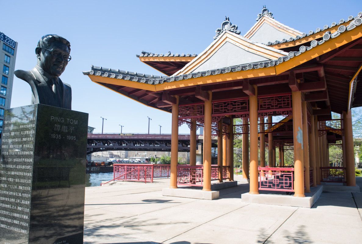
## Description Ping Tom Memorial Park is one of the most distinctive green spaces in Chicago because it feels both urban and calm at the same time. Set against the skyline and the Chicago River, it offers a combination of water views, landscaped paths, public art, and open lawns that makes it much more than a neighborhood park. For visitors who want a place that shows a different side of the city, this is one of the best spots to slow down, walk, and take in the atmosphere of Chicago’s Chinatown and riverfront. What makes the park special is the way it balances recreation, memory, and design. It was created to honor Ping Tom, a respected Chicago business leader and community advocate, but it has also become a favorite place for everyday life in the city. You will see people jogging, families gathering, photographers waiting for the light on the water, and visitors simply resting on benches with a broad view of the river. The pavilion’s architecture, inspired by traditional Chinese design, gives the park a strong sense of place and connects it to the history of the neighborhood. One little-known fact is that the park is part of a larger effort to bring public access and beauty to the south branch of the Chicago River, an area that was once much more industrial. Another detail many visitors miss is how good the park is for sunrise and late-afternoon photography, when the river reflects soft light and the downtown skyline becomes especially striking. It is also one of the easiest places in Chicago to combine a peaceful walk with a meal in Chinatown, since the park sits within walking distance of many restaurants and bakeries. The park has appeal in every season. In warm months, the river breeze and tree-lined paths make it feel refreshing even on busy days. In colder months, the open views and clean geometry of the landscape give it a quieter, almost meditative character. It is not a high-adrenaline attraction, and that is exactly why many travelers remember it so fondly. It is a place that invites you to stay a little longer than planned. For first-time visitors, the park is also useful as a way to understand how Chicago blends architecture, neighborhood identity, and public space. You can stand in one area and see the river, the city, and the cultural energy of Chinatown all at once. That layered feeling is part of what makes the park memorable. ## Location Ping Tom Memorial Park is located in Chicago, Illinois, United States, in the Chinatown neighborhood on the south branch of the Chicago River. It sits south of downtown and is closely connected to the city’s riverwalk and residential areas on the Near South Side. The address commonly associated with the park is 1700 South Wentworth Avenue, though visitors often arrive through nearby riverfront entrances and neighborhood streets. The easiest way to get there is by public transit. The CTA Red Line to Cermak-Chinatown is the most convenient option, followed by a short walk into the neighborhood and toward the river. Rideshare and taxi access are also straightforward. If you are already exploring downtown Chicago, you can make your way south by bus, bike, or a longer walk along the river corridors. Because parking in busy urban areas can be limited, public transit is usually the simplest and most relaxed choice. ## Tips - Visit in the early morning or around sunset for the best light and fewer crowds. - Wear comfortable shoes if you plan to combine the park with a Chinatown food walk. - Bring a camera or phone with a good wide-angle lens if you want skyline and river shots. - Check the weather before you go, since the open riverfront can feel windy. - Leave time for a meal nearby so the visit becomes part of a broader neighborhood experience. ## Conclusion Ping Tom Memorial Park is a calm, beautifully designed riverfront escape that pairs Chicago skyline views with the culture and energy of Chinatown. ## FAQ ### Is Ping Tom Memorial Park worth visiting? Yes. It is worth visiting if you enjoy scenic urban parks, river views, photography, and quieter public spaces that still feel connected to the city. ### How long should I spend there? Most visitors spend between 30 minutes and 1.5 hours, depending on whether they are just walking through or also taking photos and relaxing. ### Is the park good for families? Yes. It has open areas, walking paths, and a welcoming atmosphere that works well for families, couples, and solo travelers. ### Can I combine it with other attractions? Absolutely. Chinatown restaurants, local bakeries, and other Chicago riverfront spots are easy to combine with a visit. ### What is the best time of day to go? Early morning and late afternoon are the most rewarding times because the light is softer and the park feels especially peaceful. ## Links - [Chicago Park District page](https://www.chicagoparkdistrict.com/parks-facilities/tom-ping-memorial-park) - [Wikipedia article](https://en.wikipedia.org/wiki/Ping_Tom_Memorial_Park)
GemVoyage Team • World

Siberia
## Description Lake Baikal in southern Siberia is a global natural wonder: the world’s deepest and one of its oldest freshwater lakes, it holds roughly 20% of the planet’s unfrozen surface freshwater by volume. Stretching over 600 kilometers north-to-south and reaching depths of more than 1,600 meters, Baikal’s sheer scale is awe-inspiring. The lake’s crystalline waters, dramatic rifts, and seasonal extremes produce striking phenomena — from the unbelievable clarity of summer waters to the otherworldly expanses of transparent winter ice that allow you to walk, drive, or even ice-sail across a dazzling frozen surface. Baikal is also a hotspot of biodiversity and scientific interest. Its shoreline, submerged terraces, and deep basins host numerous endemic species found nowhere else on Earth, including the Baikal seal (nerpa) — the only seal species that has adapted to a fully freshwater environment — and dozens of endemic fish and invertebrates. The lake’s unique ecology is the result of millions of years of relative isolation, stable cold temperatures at depth, and complex nutrient cycling. Scientists study Baikal to better understand limnological processes, long-term climate records trapped in sediment layers, and the evolution of isolated ecosystems. For travelers, Baikal delivers a rare combination of dramatic landscapes and varied activities across seasons. In summer, the shoreline blooms with wildflowers, and mountain hikes and multi-day treks through taiga and steppe reveal panoramic views over the water. Kayaking, boat excursions, and shoreline camping let you sample the lake’s nearshore biodiversity and peaceful beaches. In winter, when the lake freezes, the surface becomes a vast frozen highway: locals and guides lead safe ice-walking excursions, cross-lake snowmobile trips, ice-fishing experiences, and festivals that celebrate the season. Photographers prize Baikal for its vivid ice formations, clear reflections, and light at dawn and dusk. Beyond natural spectacle, Baikal is threaded with human stories: small lakeside towns such as Listvyanka, the ferry-served Olkhon Island with its shamanic sites, and the city of Irkutsk — a historical gateway with Siberian wooden architecture and museums — are rich portals into local culture. Sustainable and low-impact travel is increasingly available via small-scale guesthouses, ecotour operators, and community-led tours that prioritize the lake’s protection. ## Location Lake Baikal spans the regions of Irkutsk Oblast and the Republic of Buryatia in Russia, with the lake forming a striking spine across southeastern Siberia. The city of Irkutsk is the primary gateway for international and domestic visitors, linked by the Trans-Siberian Railway and regional flights; it offers accommodations, museums, and transport connections. From Irkutsk, paved roads and seasonal bus services reach lakeside settlements like Listvyanka, Port Baikal, and the ferry terminals for Olkhon Island — the lake’s largest island and a cultural heartland with cliffs, shamanic sites, and small villages. Other access points include Ulan-Ude to the east and smaller regional airfields that connect via charter or seasonal flights. Travel times can be long, so many visitors plan multi-day itineraries that combine transit into the lake area with on-site exploration. ## Tips - **Respect seasonal access and local rules:** Ice travel and remote trails require local knowledge; always consult local guides and authorities before venturing onto the ice or into isolated areas. Safety equipment and up-to-date conditions are essential. - **Plan time for Olkhon Island:** Olkhon is a cultural and scenic highlight, with dramatic cliffs, shamanic sites, and small settlements. Allow several days to explore its coves, beaches, and sacred capes. - **Pack for extremes:** Even in summer, weather can shift quickly; bring layered clothing, waterproof shells, sturdy boots, sun protection, and insect repellent. In winter, prioritize thermal layers, insulated boots, and a reliable outer layer. - **Travel with experienced local guides:** Guides provide safety on ice crossings, access to lesser-known shorelines, wildlife-spotting skills, and cultural context about Buryat and Siberian heritage. Choose operators that practice sustainable tourism. - **Respect conservation rules:** Stick to marked paths, avoid disturbing nesting birds or haul-out sites, and follow Leave No Trace principles. Support local conservation initiatives when possible. - **Time your visit for activities:** Summer is best for hiking and kayaking; late spring and early autumn deliver fewer crowds and pleasant light; winter offers unique ice experiences but requires more planning. ## Conclusion Lake Baikal is both a living laboratory and a vast natural wonder: its depth, clarity, and ancient lineage make it one of Earth’s most singular freshwater realms. Whether you come for scientific curiosity, wilderness hiking, cultural exchange with lakeside communities, or simply to witness impossibly clear water and glass-like ice, Baikal rewards patient travel and respectful exploration. Plan carefully, choose sustainable operators, and allow enough time to move slowly around its bays and islands — the lake’s scale is best absorbed at human pace. ## FAQ - **Q: Can you swim in Lake Baikal?** A: Swimming is possible in summer at sheltered beaches and near lakeside villages, but the water remains cold even in peak months; stay near lifeguarded or popular swimming areas, enter gradually to avoid shock, and follow local safety guidance. - **Q: What is the best time to visit Lake Baikal?** A: Late June through September gives the warmest weather, flowering meadows, and easier trekking. Late winter (February–March) is ideal for ice-scenery photography and safe ice excursions when the ice is thickest and the light is crisp. Shoulder seasons offer quieter conditions. - **Q: How do I reach Olkhon Island, and do I need a vehicle?** A: Olkhon is reached via a seasonal ferry or ice road depending on the time of year. Many visitors rent 4x4 vehicles or join guided tours; public buses operate from nearby towns but capacity is limited. Plan logistics in advance, especially in peak season. - **Q: Are there wildlife viewing opportunities?** A: Yes—local guides can help you spot endemic fish species, waterbirds, and in protected offshore areas you may observe Baikal seals. Respect distance guidelines and avoid disturbing habitats. - **Q: Do I need special permits or visas to visit?** A: International visitors need a valid Russian visa. Some protected areas require entry fees or permits for camping and research; check with regional park authorities for up-to-date rules. - **Q: Is Internet and phone coverage available?** A: Coverage varies—cities like Irkutsk and larger settlements have decent mobile data; more remote shorelines and parts of Olkhon have limited connectivity. Prepare for periods offline and download maps or emergency contacts beforehand. ## Links -- [Lake Baikal — Wikipedia](https://en.wikipedia.org/wiki/Lake_Baikal)
GemVoyage Team • World
Seville
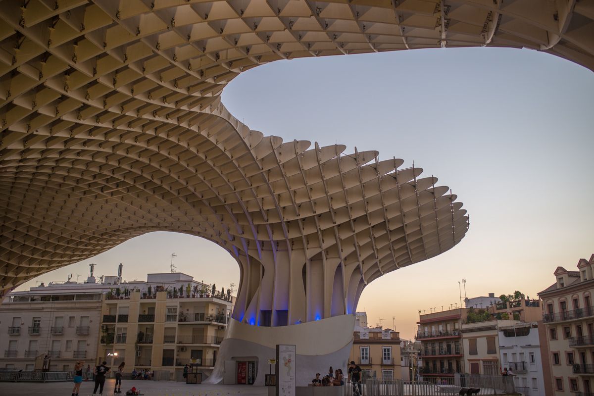
## Description Metropol Parasol, widely known as Las Setas, is one of Seville’s most striking modern landmarks and one of the clearest examples of how the city blends old and new. The structure rises above Plaza de la Encarnación with a dramatic, wave-like form that looks almost impossible at first glance. Made from timber and organized on a monumental scale, it creates a new skyline for the historic center while also serving as a public space, viewpoint, market area, and archaeological showcase. For travelers, it offers something rare: a contemporary architectural experience embedded directly in an old urban setting. What makes Metropol Parasol especially memorable is how many functions it holds at once. You can walk below it, stand under it, go up to the rooftop walkways, and also access the archaeological remains preserved underneath. That layering is a big part of its appeal. A little-known fact is that the structure is often described as one of the largest timber architectural constructions in the world, which gives it a technical significance beyond its visual impact. Another detail many visitors miss is that the underside and surrounding plaza change character depending on the time of day, with morning, afternoon, and night each creating a different mood around the same structure. For visitors who think of Seville only in terms of churches, palaces, and traditional patios, Metropol Parasol offers a useful correction. It shows that the city still experiments, still reinvents public space, and still uses architecture to make a statement. It is not only photogenic; it is conceptually important. The combination of modern design, archaeological depth, and rooftop views makes it one of the city’s most distinctive attractions for travelers who want a wider sense of Seville than the classic route alone provides. ## Location Metropol Parasol is located in Plaza de la Encarnación in the historic center of Seville, Andalusia, Spain. Because it sits in such a central area, it is easy to reach on foot from many of the city’s main sights. Visitors staying in the old town can often walk there directly, while buses and taxis provide easy access from farther away. The structure is also well positioned for combining with nearby shopping streets, tapas stops, and other central landmarks. If you are planning to go up to the top, try to visit at a time when the light is good and the city is not overwhelmingly crowded. The rooftop is especially rewarding near sunset, when the view across Seville becomes more dramatic. If you are more interested in the archaeological and urban-planning side of the site, a daytime visit can be just as worthwhile. Either way, the location makes it simple to fold into a broader sightseeing route without needing a special excursion. ## Tips - Go up to the rooftop for the best panoramic view of the historic center. - Visit near sunset if you want the most impressive light. - Don’t skip the lower level, where the archaeological remains add historical depth. - Pair the visit with nearby food or shopping to make the most of the central location. - Bring sun protection in warm months, because the plaza can be bright and exposed. - Visit at night as well if you want to see how the structure changes with illumination. ## Conclusion Metropol Parasol is one of Seville’s most original landmarks, combining modern architecture, public space, and historical layers in a single unforgettable site. It is a strong stop for travelers who want both views and design. ## FAQ ### Why is Metropol Parasol important? It is important as a bold example of contemporary architecture in Seville and as a multi-use public space. ### Can visitors go to the top? Yes. The rooftop walkways and viewpoints are one of the main reasons to visit. ### Is it good for photos? Very much so. The structure, plaza, and views offer excellent photo opportunities. ### How long does a visit take? About one hour is common, though you may stay longer if you explore the full site and surrounding area. ## Links - [Official website](https://setasdesevilla.com/) - [Wikipedia](https://en.wikipedia.org/wiki/Metropol_Parasol) - [Seville tourism information](https://www.visitasevilla.es/en)
GemVoyage Team • World
Cairo
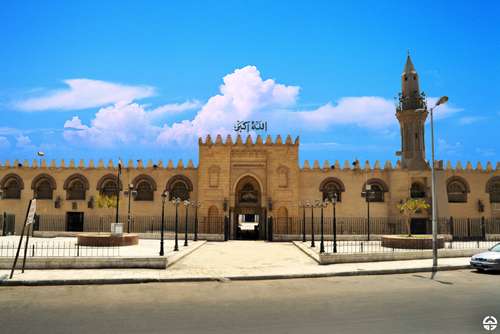
## Description The Amr Ibn Al-Aas Mosque in Cairo is not just a religious site—it’s a living monument to the birth of Islam in Egypt and Africa. Built in 641–642 CE by General Amr Ibn Al-Aas following the Arab conquest of Egypt, it holds the distinction of being the **first mosque ever constructed in Egypt and on the African continent**. Originally erected in the newly founded city of Fustat, the mosque served as both a spiritual center and a gathering place for the early Muslim community. Though the original structure was modest—little more than a roof supported by palm trunks—the mosque has undergone numerous renovations and expansions over the centuries. Today, it features a spacious courtyard, four minarets, and elegant arcades that reflect the evolution of Islamic architecture. Despite its many reconstructions, the mosque retains a sense of historical continuity and reverence. A little-known fact: the site of the mosque was chosen in a rather poetic way. Legend has it that a dove laid an egg in Amr Ibn Al-Aas’s tent before he left for battle. Upon his victorious return, he interpreted the bird’s nest as a divine sign and built the mosque on that very spot. Another intriguing detail is that several companions of the Prophet Muhammad, including al-Zubayr ibn al-‘Awam and Ubada ibn al-Samit, participated in its construction. ## Location The Amr Ibn Al-Aas Mosque is located in **Egypt**, within the **Cairo Governorate**, specifically in the historic district of **Old Cairo** (Al-Fustat). This area is rich in Islamic, Christian, and Jewish heritage, making it a cultural crossroads worth exploring. ### How to Get There: - **By Metro**: Take Cairo Metro Line 1 to Mar Girgis Station. From there, it’s a short walk to the mosque. - **By Taxi or Ride-Hailing**: Services like Uber and Careem are widely available and can drop you off directly at the entrance. - **By Tour Bus**: Many heritage tours include Old Cairo in their itinerary, often combining visits to the mosque with nearby sites like the Hanging Church and Ben Ezra Synagogue. ## Tips for Visitors To make the most of your visit to Amr Ibn Al-Aas Mosque, consider the following tips: - **Visit During Off-Peak Hours**: Early mornings or late afternoons are ideal for avoiding crowds and enjoying a peaceful experience. - **Dress Modestly**: As with any religious site, modest attire is required. Women may be asked to cover their hair. - **Respect Prayer Times**: The mosque is active and hosts regular prayers. Non-Muslim visitors should avoid entering during these times unless invited. - **Explore the Surroundings**: Old Cairo is a treasure trove of history. Allocate time to visit nearby religious and archaeological sites. - **Hire a Guide**: A local guide can enrich your visit with historical context and stories that aren’t found on plaques. - **Photography**: While photography is generally allowed, be respectful and avoid taking pictures of worshippers. ## Conclusion The Amr Ibn Al-Aas Mosque is more than just a place of worship—it’s a cornerstone of Islamic history in Africa. With its deep historical roots, architectural evolution, and spiritual significance, it offers visitors a profound glimpse into Egypt’s Islamic heritage and the early days of Fustat. ## FAQ **1. When was the Amr Ibn Al-Aas Mosque built?** It was originally constructed in 641–642 CE, making it the oldest mosque in Egypt and Africa. **2. Is the mosque still active today?** Yes, it remains an active place of worship and is open to visitors outside of prayer times. **3. Can non-Muslims visit the mosque?** Yes, non-Muslims are welcome, but should avoid entering during prayer times and dress respectfully. **4. Is there an entrance fee?** No, entry to the mosque is free, though donations for upkeep are appreciated. **5. What are the mosque’s opening hours?** Typically, it’s open from 9:00 AM to 4:00 PM, but hours may vary during religious holidays. **6. What other attractions are nearby?** Nearby sites include the Hanging Church, Ben Ezra Synagogue, and the Coptic Museum—all within walking distance. ## Links - [Wikipedia – Amr Ibn Al-Aas Mosque](https://en.wikipedia.org/wiki/Amr_ibn_al-As_Mosque) - [Egyptian Ministry of Tourism – Amr Ibn Al-Aas Mosque](https://egymonuments.gov.eg/monuments/the-mosque-of-amr-ibn-al-as)
GemVoyage Team • World
Milan
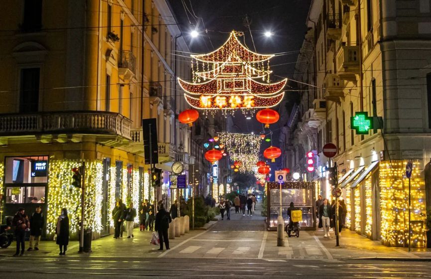
## Description **Chinatown in Milan (Quartiere Cinese di Milano)** is a lively, colorful district that blends **Italian sophistication with Chinese tradition**, creating one of the most vibrant cultural areas in northern Italy. Established in the early 20th century, it is the **oldest and largest Chinatown in Italy**, and today it thrives as a bustling hub of food, culture, and community life. The neighborhood is centered around **Via Paolo Sarpi**, a pedestrian-friendly street lined with Asian grocery stores, authentic restaurants, tea shops, and modern fashion boutiques. Red lanterns and bilingual signs decorate the streets, while the aroma of dumplings, noodles, and roasted duck fills the air. It’s a place where tradition meets innovation — where family-run Chinese bakeries coexist with trendy Milanese cafés and design studios. What makes Milan’s Chinatown unique is how seamlessly it integrates into the city’s cosmopolitan identity. Beyond being a culinary destination, it’s also a **center for art, trade, and cross-cultural exchange**. The area has become increasingly popular among young professionals and artists who appreciate its multicultural atmosphere and creative energy. A little-known fact is that Chinatown in Milan began as a **settlement of Chinese workers from Zhejiang province** in the 1920s, who came to Italy to work in the textile and leather industries. Over time, they established businesses that became essential to Milan’s fashion scene — a legacy that still endures today. Another fascinating detail: every year, the neighborhood hosts an elaborate **Chinese New Year parade**, drawing thousands of locals and tourists to celebrate with dragon dances, fireworks, and street performances. ## Location Milan’s Chinatown is located in the **northwestern part of the city center**, primarily along **Via Paolo Sarpi** in the **Porta Volta area**, **Lombardy region**, **Italy**. To get there: * **By metro:** Take **Line 2 (Green Line)** to **Moscova Station** or **Line 5 (Purple Line)** to **Monumentale Station**. Both are a short walk from Via Paolo Sarpi. * **By tram:** Tram lines **12 and 14** stop nearby. * **By foot:** It’s about a **15–20 minute walk** from the Duomo or Brera district, making it an easy stop during a city stroll. The area is pedestrian-friendly, making it perfect for exploring on foot while sampling food or browsing local shops. ## Tips * **Come hungry:** Chinatown is one of the best places in Milan for authentic Chinese, Vietnamese, and Thai cuisine. Popular dishes include **dim sum, baozi (steamed buns),** and **hand-pulled noodles**. * **Visit during Chinese New Year:** The celebrations are among the largest in Italy, featuring parades, performances, and cultural exhibits. * **Explore side streets:** Don’t just stay on Via Paolo Sarpi — nearby lanes hide charming bakeries, tea shops, and Asian supermarkets. * **Try local fusion spots:** Milan’s creativity shines through in restaurants that blend Asian and Italian flavors, reflecting the district’s evolving culinary scene. * **Shop for Asian ingredients:** Supermarkets like **Kathay** are famous for offering rare spices, sauces, and produce that are hard to find elsewhere in Italy. * **Visit in the evening:** As the lights come on, the red lanterns and street buzz create a magical, cinematic atmosphere. ## Conclusion **Chinatown in Milan** is far more than a neighborhood — it’s a living story of migration, adaptation, and community. From its early days as a textile hub to its present status as a vibrant cultural destination, it reflects Milan’s openness and diversity. Whether you’re tasting authentic dim sum, shopping for exotic ingredients, or celebrating Chinese New Year, Chinatown offers a sensory journey through the heart of modern multicultural Milan. ## FAQ **1. When was Chinatown in Milan established?** It was founded in the **1920s** by Chinese immigrants, mainly from Zhejiang province, who came to work in textile and leather industries. **2. Where exactly is it located?** It centers around **Via Paolo Sarpi**, in the **Porta Volta area** of **Milan**, **Lombardy, Italy**. **3. What can I do there?** You can explore Asian shops, enjoy authentic Chinese cuisine, visit tea houses, and attend cultural festivals such as Chinese New Year. **4. Is it safe to visit Chinatown at night?** Yes, it’s considered safe and lively, with many restaurants and bars open until late. **5. What’s the best time to visit?** Any time of year is great, but **January or February** during the **Chinese New Year** offers the most festive experience. **6. Are there Italian-Chinese fusion restaurants?** Yes, several trendy eateries combine Asian flavors with Italian ingredients, reflecting the creative spirit of Milan’s dining scene. ## Links * [Official Milano Tourism Portal](https://www.yesmilano.it)
GemVoyage Team • World

Comments