GemVoyage Team • World
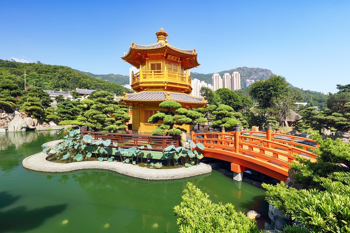
The garden stands out because every part of it feels intentional. Paths curve in a way that reveals views gradually, water is placed to reflect architecture and sky, and the plant life is arranged to create a sense of harmony rather than display. It is not a large theme park style attraction; instead, it rewards observation and a slower pace. Visitors often leave surprised by how much visual richness can be packed into a relatively compact space without feeling crowded.
One little-known fact is that Nan Lian Garden was designed to echo the aesthetics of the Tang dynasty, which means the landscape is guided by historical artistic principles rather than modern ornamental trends. Another detail many people miss is the garden’s ability to change character with the weather. On a bright day, the orange, red, and green tones look crisp and vivid. On a misty or overcast day, the place becomes softer and more contemplative, almost like a living painting.
The nearby cultural surroundings also add depth to the visit. Many travelers pair the garden with adjacent spiritual and architectural sites because the whole area encourages a thoughtful pace. Even if you only have a short time, the garden can leave a strong impression because it feels so different from the surrounding city. It is carefully maintained but not sterile, elegant but not intimidating, and peaceful without feeling empty.
Another reason the garden is memorable is that it offers a very photogenic composition without requiring any special effort. Reflections, stonework, and traditional roofs create good images from many angles. Still, the real value of the place is not just visual. It is the emotional contrast between the garden and the rest of Hong Kong. That contrast is what makes the visit feel restorative.
Because the garden is centrally accessible by public transport, it fits easily into a Hong Kong itinerary. You do not need a special transfer or long taxi ride to get there. If you are already in Kowloon, it is especially easy to combine with nearby neighborhoods or with other cultural stops in the same district. Arriving by MTR is generally the simplest and most efficient option.
Discover more hidden gems you might love.

Karachi
## Description Mohatta Palace is one of Karachi’s most iconic architectural gems, blending history, culture, and artistry into a single breathtaking experience. Built in 1927 by Shivratan Chandraratan Mohatta, a wealthy Hindu Marwari businessman, the palace was originally intended as a summer retreat. Designed by architect Agha Ahmed Hussain, it showcases the Indo-Saracenic style, combining elements of Mughal and Rajasthani architecture. The structure is made of pink Jodhpur stone and local yellow Gizri stone, giving it a warm, regal glow that stands out in the heart of Clifton. The palace spans over 18,500 square feet and features nine domes, intricately carved windows, floral motifs, and a grand central dome that crowns the building. Inside, visitors find polished teak wood staircases, long corridors, and stately rooms that once hosted lavish gatherings. Today, Mohatta Palace functions as a museum, hosting exhibitions that celebrate Pakistan’s rich artistic and cultural heritage—from miniature paintings and textiles to contemporary art installations. A little-known fact: the palace once housed a private temple dedicated to Lord Shiva on its rooftop terrace, a quiet reminder of its original owner's spiritual life. Another intriguing detail is the presence of secret underground tunnels, rumored to have been used for discreet movement during political unrest—though these remain closed to the public. ## Location Mohatta Palace is located in **Karachi**, the largest city in **Pakistan**, within the **Sindh** province. Specifically, it sits in the upscale neighborhood of **Old Clifton**, at 7 Hatim Alvi Road, Block 5. ### How to Get There: - **By Car**: Easily accessible via Shahrah-e-Faisal or the Clifton Bridge. Parking is available nearby. - **By Public Transport**: Local buses and ride-hailing services like Careem and Uber can drop you off directly at the entrance. - **From Jinnah International Airport**: The palace is about a 45-minute drive depending on traffic. For tourists, hiring a local guide or joining a heritage tour can enhance the experience with historical context and insider stories. ## Tips for Visitors To make the most of your visit to Mohatta Palace, keep these tips in mind: - **Check Exhibition Schedules**: The museum hosts rotating exhibitions, so check ahead to catch something that aligns with your interests. - **Photography**: While photography is allowed in the gardens, it’s restricted inside the museum. Ask staff for permission if you're documenting your visit. - **Dress Comfortably**: The palace grounds are expansive, and Karachi’s climate can be warm—light clothing and comfortable shoes are recommended. - **Visit Early**: Arriving early helps avoid crowds and gives you time to explore the gardens and nearby attractions. - **Guided Tours**: Opt for a guided tour to uncover stories and architectural details you might otherwise miss. - **Cultural Etiquette**: Respect the museum’s quiet ambiance and avoid loud conversations or disruptive behavior. ## Conclusion Mohatta Palace is more than a historical building—it’s a living museum that bridges the past and present of Pakistan’s cultural identity. With its stunning architecture, rich history, and vibrant exhibitions, it offers a unique and enriching experience for anyone visiting Karachi. ## FAQ **1. What are the opening hours of Mohatta Palace?** Typically, the museum is open from 11:00 AM to 6:00 PM, Tuesday to Sunday. It’s closed on Mondays and public holidays. **2. Is there an entry fee?** Yes, a nominal fee is charged for entry. Discounts may be available for students and groups. **3. Can I take photos inside the palace?** Photography is allowed in the gardens but restricted inside the museum. Always check with staff before taking pictures. **4. Are guided tours available?** Yes, guided tours are available and highly recommended for a deeper understanding of the palace’s history and exhibitions. **5. Is Mohatta Palace wheelchair accessible?** Accessibility is limited due to the historic nature of the building. It’s best to contact the museum in advance for specific accommodations. **6. What kind of exhibitions are held at Mohatta Palace?** Exhibitions range from traditional arts and crafts to contemporary visual art, often highlighting themes of heritage, identity, and social change. ## Links - [Mohatta Palace Official Website](https://mohattapalacemuseum.org/) - [Wikipedia – Mohatta Palace](https://en.wikipedia.org/wiki/Mohatta_Palace)
GemVoyage Team • World
Lille
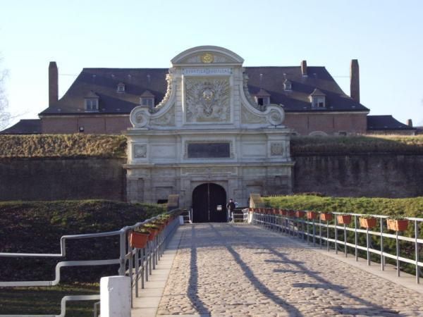
## Description The Citadel of Lille is one of the most impressive military structures in France and a major reason the city is often mentioned in discussions of European fortress design. Built in the 17th century under the direction of Vauban, the citadel is a star-shaped defensive complex that demonstrates both engineering precision and political ambition. It was intended to protect Lille after the city came under French control, and today it stands as a reminder of how military architecture could also shape a city's identity and landscape. What makes the citadel special is that it is not only technically significant but also visually elegant. Its geometric form, wide moats, robust bastions, and open green surroundings make it feel like a fortress designed by someone who understood both defense and urban order. Even if you are not deeply interested in military history, the citadel is compelling because of how it connects architecture, public space, and the natural environment. It is both a monument and a park-like setting, which gives it a very different feeling from densely built old-town landmarks. One little-known fact is that the Citadel of Lille is sometimes referred to as the "queen of citadels" because of its importance in Vauban's defensive system. Another detail many visitors miss is how well the structure fits into the modern city. Although originally conceived for warfare, the citadel now helps define a recreational and cultural zone where walking, cycling, family outings, and visits to nearby attractions all take place. That transformation from military stronghold to civic landmark is part of what makes the site interesting today. The citadel also helps visitors understand Lille's broader history. The city sat near contested borders for centuries, so fortifications were more than symbolic; they were necessary tools of survival and control. Standing at the citadel, you can sense the strategic value of the location and see how a military engineer like Vauban thought about terrain, sightlines, and access. For architecture lovers, history enthusiasts, and casual walkers alike, it is one of Lille's most rewarding destinations. ## Location The Citadel of Lille is in Lille, in the Hauts-de-France region of France, west of the historic center near the Deûle River and surrounding parkland. Its location makes it easy to combine with a broader exploration of Lille's old quarters, especially if you are already spending time around the city center. Unlike a fortress in a remote military zone, this citadel sits comfortably within the urban fabric while still feeling spacious. Getting there is simple by foot, bicycle, or local transport. If you are staying in central Lille, a walk to the citadel is pleasant and reveals how the city's layout changes as you move from dense streets to more open green space. Buses and taxis can also bring you close, but many visitors prefer to use the approach as part of a longer stroll. Because the citadel is surrounded by parks and walking routes, it works especially well as part of a relaxed day outdoors. You can combine it with the nearby zoo, river paths, or other west-side attractions if you want to make the most of the area. ## Tips Allow time for the surroundings as well as the fortress itself. The citadel's setting in parkland is one of its greatest strengths, and the experience improves when you treat it as part of a broader walk rather than a quick photo stop. If you are interested in military history, read a little about Vauban before visiting. His work shaped many French fortifications, and understanding his methods makes the citadel much more meaningful. Visit in good weather if you want to enjoy the outdoor environment fully. The site is enjoyable year-round, but clear conditions make the geometry and scale easier to appreciate. Bring comfortable shoes or use a bicycle if you plan to cover more of the surrounding area. The citadel fits naturally into an active day in Lille and is especially pleasant for travelers who enjoy a mix of history and open-air walking. ## Conclusion The Citadel of Lille is a landmark of French military architecture and a beautiful place to understand the strategic history of the city while enjoying one of its most open and pleasant landscapes. ## FAQ ### Who built the Citadel of Lille? It was designed by Vauban, the famous French military engineer, in the 17th century. ### Why is the citadel important? It is important because it is one of the best examples of Vauban's fortification work and a key part of Lille's historical defense. ### Can you visit the citadel today? Yes. The area is accessible and widely used for walking and recreation, though access may vary in specific sections. ### Is it close to Lille's city center? Yes. It is located west of the center and is easy to reach on foot or by local transport. ## Links - [Lille tourism](https://www.lilletourism.com/) - [Wikipedia article](https://en.wikipedia.org/wiki/Citadel_of_Lille)
GemVoyage Team • World

Oslo
## Description Vigeland Sculpture Park is already one of Oslo’s essential attractions, but its hidden corners offer a more thoughtful and rewarding experience for visitors who go beyond the main axis. Most people know the central path and the iconic sculptures that define the park’s visual identity, but the quieter side areas, peripheral routes, and less obvious viewpoints can reveal a different relationship between sculpture, space, and public life. Exploring these hidden corners gives the park a more layered feeling and helps you appreciate it as a landscape rather than just a photo stop. The obvious sculptures draw crowds for good reason, but the park’s subtler areas often show how carefully the whole environment has been designed. Small changes in angle, distance, and elevation can alter how you perceive the figures and the surrounding open space. That means a visit can become a kind of visual study if you take your time. One lesser-known fact is that the park has been shaped around a long artistic vision that extends beyond individual sculptures, which is why the less visited areas still feel coherent rather than secondary. Another interesting point is that weather and light dramatically change the experience, so even a familiar sculpture can feel new when viewed from a quiet side path. For travelers, the hidden corners are especially appealing if they want to avoid the most crowded photo spots or if they have already seen the park’s main highlights. You do not need to be an art specialist to enjoy this approach; in fact, simply slowing down and paying attention is enough. The hidden areas often reward curiosity more than prior knowledge. That makes them ideal for repeat visitors, photographers, and anyone who prefers an experience that feels slightly less scripted. ## Location Vigeland Sculpture Park is in the Frogner area of Oslo, Norway, within the larger Frogner Park. The hidden corners are scattered through the same park grounds, so they are reached by moving away from the busiest central promenade and exploring the surrounding paths. The easiest way to get there is by tram, bus, or a walk from central Oslo, followed by time on foot inside the park. Since the best hidden corners are not signposted as a separate attraction, the main strategy is to arrive at the park and then wander with intention. Comfortable walking shoes matter more than anything else. ## Tips Go early or late in the day if you want fewer crowds and more space to explore. Do not focus only on the central sculpture axis; the quieter side paths are where the hidden corners reveal themselves. Bring a camera and spend time looking back toward the main sculptures from different angles. If you have already visited once, return in another season to see how the mood changes. ## Conclusion The hidden corners of Vigeland Sculpture Park offer a richer, calmer, and more reflective way to experience one of Oslo’s signature cultural landscapes. ## FAQ ### What are the hidden corners of Vigeland Sculpture Park? They are the quieter side paths and less obvious areas beyond the park’s main sculptural route. ### Is this different from the main park visit? Yes. It is a more exploratory way to experience the same park. ### Do I need a guide to find them? No, but a slow walk and willingness to wander help a lot. ### Is it worth doing if I have already seen the park? Definitely. It gives you a deeper perspective on the layout and atmosphere. ### When is the best time to explore? Early morning, late afternoon, or any quieter period with good light. ## Links - [Official Vigeland Park information](https://vigeland.museum.no/en/vigelandpark) - [Vigeland Park on Wikipedia](https://en.wikipedia.org/wiki/Vigeland_Sculpture_Park)
GemVoyage Team • World
Alkmaar
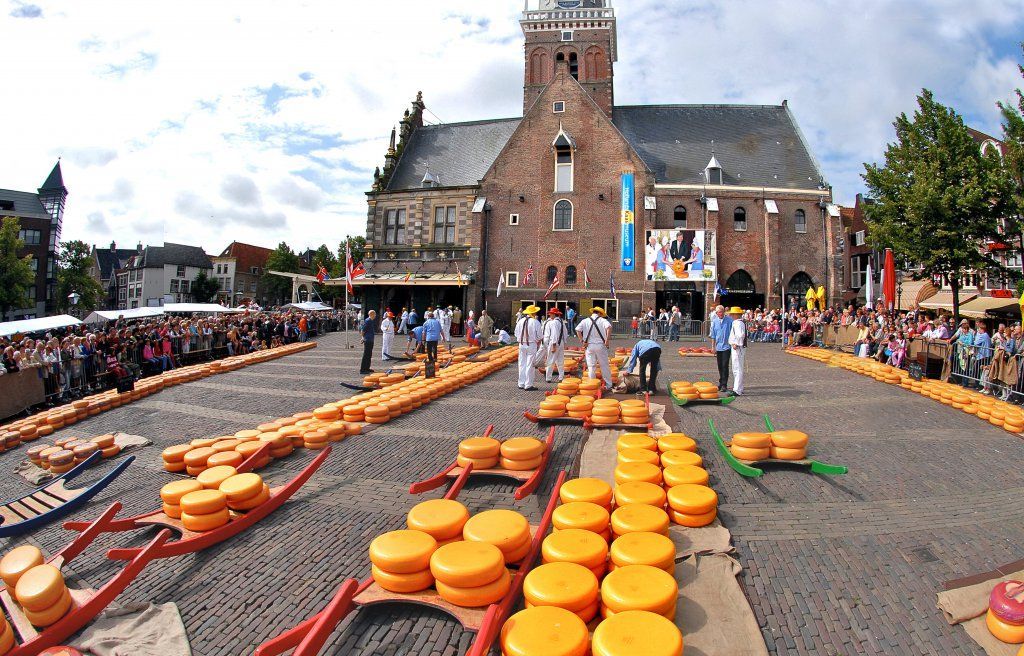
## Description The Alkmaar Cheese Museum is one of the best places to understand why cheese is such an important part of Dutch identity and regional heritage. Located in the historic Waag building, the museum explores the history, production, trade, and cultural significance of cheese in the Netherlands, with special attention to Alkmaar’s long association with the cheese market tradition. It is a compact but engaging museum that helps visitors see cheese not just as food, but as part of a larger economic and social story. One of the museum’s strengths is its accessibility. It presents information in a way that is easy to follow for casual visitors while still giving enough depth to satisfy people interested in local history. The setting matters too: being in a historic weighing house adds a strong sense of place. One lesser-known fact is that Alkmaar’s cheese heritage is linked not only to local farming but also to the broader trading systems that shaped Dutch cities for centuries. Another interesting detail is that the museum helps explain the rituals and practical logistics behind cheese commerce, including how products were measured, moved, and valued in a market town. The museum is also a good reminder that cultural attractions do not have to be large to be effective. Its size makes it easy to fit into a walking day in Alkmaar, and it works especially well when combined with the city’s old streets, canals, and other historic sites. For many visitors, the appeal is partly culinary and partly atmospheric: you learn about cheese, but you also absorb the character of a Dutch market city that built part of its identity around this trade. That makes the museum feel both educational and local. ## Location The Alkmaar Cheese Museum is in the center of Alkmaar, North Holland, the Netherlands, inside the historic Waag building near the city’s old market area. Because it is centrally located, it is easy to reach on foot from most of Alkmaar’s historic core. If you are coming by train, Alkmaar’s station connects well to the city center, and the walk to the museum is straightforward. Visitors arriving from Amsterdam or other nearby cities usually find the trip simple by rail, making it a practical day trip destination. Once in town, the compact center is best explored on foot. ## Tips Combine the museum with a visit to Alkmaar’s historic center for the full experience. If you are interested in the traditional cheese market, check the schedule before your trip so you can align your visit. The museum is a good rainy-day option because it is compact and easy to visit without much planning. Leave room in your itinerary for tasting local cheese or exploring nearby shops. ## Conclusion The Alkmaar Cheese Museum is a small but worthwhile stop that turns the city’s cheese heritage into a clear and enjoyable cultural visit. ## FAQ ### What does the Alkmaar Cheese Museum focus on? It explains the history, trade, and cultural importance of cheese in Alkmaar and the Netherlands. ### Is the museum connected to the cheese market? Yes, it is closely tied to Alkmaar’s famous cheese-trading tradition. ### How much time do I need? A visit usually takes around one hour, depending on how much you read. ### Is it suitable for children? Yes, especially for families that want a short, easy museum visit with a clear theme. ### Can I visit it together with the cheese market? Yes, and that is one of the best ways to experience Alkmaar’s cheese culture. ## Links - [Official website](https://www.kaasmuseum.nl/en/)
GemVoyage Team • World
Denmark
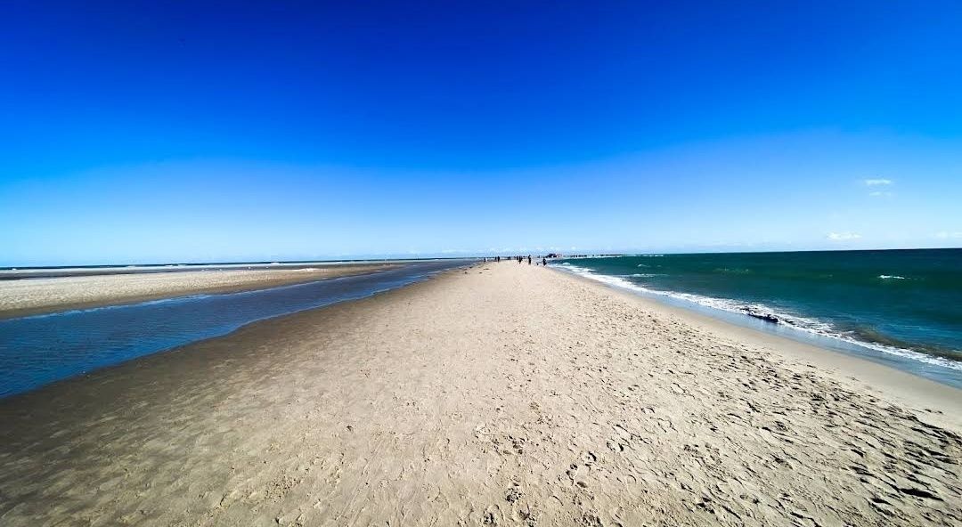
## Description **Grenen** is one of Denmark’s most extraordinary natural landmarks, where two seas—the **Skagerrak** and the **Kattegat**—dramatically meet. At the northernmost tip of Jutland, visitors can witness the unique sight of waves colliding from different directions, creating a visible line in the water. This natural phenomenon makes Grenen one of Denmark’s most visited and photographed attractions. The area is not just about the sea—it’s a place of raw beauty. The sandbar stretches far out into the water, and as you walk along the beach, you’ll be surrounded by endless skies, shifting sands, and fresh sea air. Many visitors find it both a peaceful and powerful experience. **Little-known facts**: * Grenen has been gradually moving northeast for centuries due to sand and tidal currents. The spit extends a few meters every year, reshaping the coastline bit by bit. * The area is also a paradise for birdwatchers. Because of its geographical location, Grenen is one of the best places in Denmark to spot migratory birds, especially in spring and autumn. --- ## Location Grenen is located just outside **Skagen**, a charming coastal town at the very top of **North Jutland**, in **Denmark**. Skagen itself is known for its distinctive yellow houses with red-tiled roofs and its long artistic tradition, but Grenen is the crown jewel of the area. ### How to get there: * From **Skagen town center**, Grenen is about 3 kilometers away. Visitors can walk, cycle, or take the famous **Sandormen tractor bus**, which transports people directly to the tip of the spit. * If you’re coming from other parts of Denmark, you can reach Skagen by train or bus via Frederikshavn, or by car along the scenic coastal roads. Once in Skagen, Grenen is well signposted and easy to access. --- ## Tips * **Wear suitable shoes**: The sandy terrain can be uneven, and the walk to the very tip can take around 20–30 minutes. Comfortable shoes or sandals are recommended. * **Don’t swim**: Although it may be tempting, swimming at Grenen is strictly discouraged. The currents where the two seas meet are extremely strong and unpredictable. * **Try the Sandormen ride**: The tractor-pulled bus called *Sandormen* has been operating since 1947 and is a fun, practical way to reach the very end of the spit. * **Bring a camera**: The meeting of the seas is a stunning photo opportunity, especially at sunset when the sky lights up in beautiful colors. * **Visit Skagen’s attractions too**: After Grenen, explore Skagen’s art museums, lighthouses, and the nearby Råbjerg Mile, Denmark’s largest migrating sand dune. --- ## Conclusion Grenen is more than just Denmark’s northern tip—it’s a rare natural spectacle where two seas clash, shaping the land and leaving visitors in awe. Its ever-changing landscape, combined with rich wildlife and historical charm, makes it a must-see for anyone traveling to North Jutland. Whether you walk barefoot in the sand, take the Sandormen, or simply sit and admire the horizon, a visit to Grenen promises memories of Denmark’s wild and beautiful coastline. --- ## FAQ **1. What makes Grenen special?** Grenen is where the Skagerrak and Kattegat seas meet, creating a visible collision of waves. It’s also one of Denmark’s most scenic natural areas. **2. Can you swim at Grenen?** No, swimming is not allowed due to extremely strong and dangerous currents at the meeting point of the seas. **3. How do you get to the very tip of Grenen?** You can walk along the beach from Skagen or take the Sandormen tractor bus, which drives visitors directly to the point. **4. Is Grenen suitable for children and families?** Yes, Grenen is family-friendly. Kids usually enjoy the tractor ride and spotting seals or birds along the coast, but parents should keep them away from the water’s edge. **5. Are there animals to see at Grenen?** Yes, Grenen is known for bird migration, and you may also see seals resting on the sandbanks. **6. When is the best time to visit Grenen?** Grenen is open year-round, but the best times are spring and summer for pleasant weather, or autumn for dramatic skies and bird migration. --- ## Links * [Visit Denmark – Grenen](https://www.visitdenmark.com/denmark/plan-your-trip/grenen-skagen-gdk640520) * [Sandormen Tractor Bus – Official Info](https://www.sandormen.dk/)
GemVoyage Team • World
Zanzibar
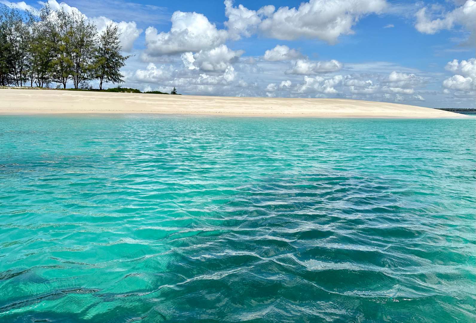
## Description Sinda Island is a hidden gem off the coast of Tanzania, often mistaken as part of Zanzibar due to its proximity and tropical allure. This uninhabited island, part of the Dar es Salaam Marine Reserve System (DMRS), offers a pristine escape into nature, far removed from the crowds and commercialization of more popular destinations. With its untouched beaches, vibrant coral reefs, and rich biodiversity, Sinda Island is a haven for eco-tourists, snorkelers, and anyone seeking tranquility. The island is actually composed of two parts—Inner and Outer Sinda—each with its own unique landscape. The coastlines feature a mix of rocky cliffs and soft sandy beaches, while the interior is covered in virgin coastal forest. One of the island’s most fascinating residents is the endangered coconut crab, which thrives in this protected habitat. The waters surrounding Sinda are shallow near the shore but drop off dramatically just a few kilometers out, creating strong tidal currents and excellent snorkeling conditions. A little-known fact: Sinda Island is home to ruins dating back to the 19th century, and it was first documented by Arab sailor Ibn Majid in 1470. These remnants of history, combined with the island’s natural beauty, make it a compelling destination for both adventure and reflection. ## Location Sinda Island is located in **Tanzania**, within the **Dar es Salaam Region**, specifically in the **Kigamboni District**. It lies southeast of Dar es Salaam, just off the coast near the Somangila ward. ### How to Get There: - **By Boat**: The most common way to reach Sinda Island is by hiring a boat from the Kigamboni coast. Local tour operators offer day trips that include snorkeling, picnicking, and guided walks. - **From Dar es Salaam**: Take a ferry across the harbor to Kigamboni, then arrange a boat transfer from one of the nearby beaches such as Kimbiji or Sinda Beach. - **By Tour Package**: Several eco-tourism companies offer curated trips to Sinda Island, often including stops at nearby reefs and islands. Because it’s a protected area, access may be regulated, so it’s best to coordinate with licensed guides or marine reserve authorities. ## Tips for Visitors To make the most of your visit to Sinda Island, consider these tips: - **Pack Light but Smart**: Bring reef-safe sunscreen, snorkeling gear, water, and snacks. There are no facilities on the island. - **Respect the Environment**: As a protected marine reserve, it’s crucial to avoid littering and disturbing wildlife. - **Snorkeling is a Must**: The coral reefs around Sinda are teeming with life—from clownfish to moray eels. Don’t miss the chance to explore them. - **Visit During Dry Season**: June to October offers the best weather and visibility for underwater activities. - **Explore the Ruins**: Ask your guide to show you the historical ruins—some are hidden within the forest and offer a glimpse into the island’s past. - **Ideal for Day Trips**: Overnight stays are not permitted, so plan for a full-day excursion. ## Conclusion Sinda Island is a serene and ecologically rich destination that blends natural beauty with historical intrigue. Whether you're snorkeling among vibrant reefs, spotting rare coconut crabs, or simply soaking in the silence, this island offers a rare kind of escape—one that’s both peaceful and profound. ## FAQ **1. Is Sinda Island part of Zanzibar?** No, it’s located off the coast of Dar es Salaam, though it shares similar tropical features. **2. Can I stay overnight on Sinda Island?** No, the island is uninhabited and part of a protected marine reserve. Only day trips are allowed. **3. What activities can I do on the island?** Snorkeling, nature walks, beach picnics, and exploring historical ruins are popular activities. **4. Is there an entrance fee?** Yes, a small conservation fee may be required. It’s usually included in guided tour packages. **5. Are there facilities on the island?** No, there are no restaurants, restrooms, or shops. Visitors must bring their own supplies. **6. Is it safe to swim around Sinda Island?** Yes, but always follow your guide’s instructions. Some areas have strong currents due to tidal shifts. ## 🔗 Links - [Sinda Island – Wikipedia](https://en.wikipedia.org/wiki/Sinda_Island) - [Tanzania Tourism – Sinda Island Marine Reserve](https://www.tanzaniatourism.com/destination/sinda-island-marine-reserve)
GemVoyage Team • World

Comments