GemVoyage Team • World
The Liberation of Paris Museum (Musée de la Libération de Paris – Musée du Général Leclerc – Musée Jean Moulin) is one of the most important modern history museums in the French capital. Dedicated to the German occupation of Paris (1940–1944), the French Resistance, and the Liberation of Paris, the museum offers a clear, unsentimental account of how the city endured, resisted, and ultimately reclaimed its freedom during World War II.
What distinguishes this museum is its focus on individuals rather than abstract events. Through personal letters, photographs, uniforms, clandestine newspapers, and everyday objects, the museum tells the story of ordinary Parisians alongside key historical figures such as Jean Moulin, a central figure of the French Resistance, and General Philippe Leclerc, commander of the Free French forces that entered Paris in August 1944. The narrative is chronological and grounded, avoiding glorification while emphasizing moral courage and civil resistance.
One of the museum’s most striking features is the preserved underground command bunker used by Colonel Henri Rol-Tanguy during the final days of the liberation. Visitors can descend into this space, which remains intact, offering a rare and visceral sense of wartime decision-making under pressure. A lesser-known fact is that this bunker was rediscovered relatively late and restored as part of the museum’s redesign. Another notable detail is that the museum relocated in 2019 to its current site to better reflect the historical geography of the liberation events.
The museum is immersive without being overwhelming. It balances historical rigor with accessibility, making complex political and military developments understandable without diluting their seriousness.
Country: France
Region: Île-de-France
City: Paris
Arrondissement: 14th arrondissement
The museum is located on Place Denfert-Rochereau, a historically symbolic site connected to resistance activity and wartime infrastructure.
* Lines 4 and 6 to Denfert-Rochereau station.
* RER B stops at Denfert-Rochereau, providing direct access from airports and suburbs.
* Several bus lines stop directly at the square.
* Easily reachable from Montparnasse and surrounding neighborhoods.
The Liberation of Paris Museum offers a sober, powerful exploration of one of the city’s defining moments. Through personal stories, preserved spaces, and clear historical context, it transforms the liberation of Paris from a symbolic event into a deeply human experience.
1. Is the museum free to visit?
Yes, permanent exhibitions are free for all visitors.
2. How long does the visit take?
Approximately 90 minutes to 2 hours, depending on interest level.
3. Is the underground bunker accessible?
Yes, but access may be limited at busy times due to space constraints.
4. Is the museum suitable for non-French speakers?
Yes. Exhibits are well-labeled, and much of the content is available in multiple languages.
5. Does the museum focus only on Paris?
Primarily, but it also addresses broader resistance networks and Free French operations.
6. Is photography allowed?
Photography is generally permitted, but flash and tripods may be restricted.
Discover more hidden gems you might love.
Oslo
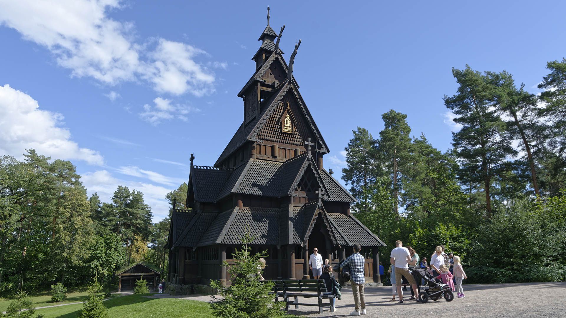
## Description **Gol Stave Church (Gol stavkirke)** is one of Norway’s most significant surviving examples of medieval wooden church architecture and a powerful symbol of the country’s cultural heritage. Originally built around the **late 12th century** in the town of Gol, the church represents the stave church tradition, a uniquely Scandinavian architectural form constructed almost entirely of timber using vertical load-bearing posts, or “staves.” What makes Gol Stave Church particularly remarkable is not only its age, but its **story of survival**. By the 19th century, many stave churches were being demolished due to changing religious practices and maintenance costs. Gol Stave Church was dismantled in the 1880s and narrowly avoided destruction thanks to the intervention of King Oscar II, who recognized its historical value. The church was carefully relocated and reconstructed on the Bygdøy peninsula in Oslo, where it stands today as a centerpiece of Norway’s architectural memory. Architecturally, the church combines Christian symbolism with **Viking-era decorative traditions**. Carved dragon heads, interlacing wood patterns, and animal motifs reflect pre-Christian Norse art, subtly integrated into a Christian sacred structure. This blending of belief systems is one of the most fascinating aspects of stave churches and offers insight into Norway’s transition from paganism to Christianity. A lesser-known fact is that much of what visitors see today is based on **meticulous historical reconstruction**, informed by archaeological studies, surviving stave churches, and medieval building techniques. Another interesting detail is that Gol Stave Church was never intended to function as an active parish church in Oslo; its role is primarily educational and cultural, serving as a reference model for lost stave churches across Norway. Gol Stave Church is not large, but its craftsmanship, symbolism, and historical weight give it a presence that far exceeds its physical scale. ## Location **Country:** Norway **Region:** Eastern Norway **City:** Oslo **Area:** Bygdøy Peninsula Gol Stave Church is located within the grounds of the **Norwegian Museum of Cultural History (Norsk Folkemuseum)**, an open-air museum dedicated to Norway’s cultural and architectural history. ### How to Get There * **By bus:** * Bus lines from central Oslo (such as from Nationaltheatret or Jernbanetorget) run directly to Bygdøy. * **By ferry (seasonal):** * Ferries operate from the Oslo harbor to Bygdøy, offering a scenic approach during warmer months. * **By bicycle:** * A pleasant option in good weather, with dedicated cycling routes leading to the peninsula. * **By taxi:** * Easily accessible by taxi from central Oslo. ## Tips * **Combine with the open-air museum:** Gol Stave Church is part of a much larger cultural complex; allow enough time to explore. * **Visit during daylight hours:** Natural light enhances the carved details and wood textures. * **Read the interpretive panels:** They explain stave church construction and symbolism clearly. * **Expect authenticity, not luxury:** Interiors are simple and atmospheric rather than ornate. * **Dress for the weather:** Much of the surrounding museum is outdoors. * **Photography rules apply:** Interior photography may be restricted. ## Conclusion Gol Stave Church is a rare and powerful reminder of medieval Norway’s craftsmanship, belief systems, and architectural ingenuity. Its careful preservation and relocation allow visitors to experience a building type that once defined Norwegian religious life but has nearly vanished. ## FAQ **1. Is Gol Stave Church still an active church?** No, it functions as a historical exhibit rather than a place of worship. **2. How old is the church?** It dates back to approximately the late 1100s. **3. Is it an original building or a replica?** It is a reconstructed original, assembled using historic materials and techniques. **4. How much time should I plan for the visit?** Plan **1.5 to 3 hours** if combining it with the surrounding museum. **5. Is it suitable for children?** Yes, especially for children interested in history and Viking culture. **6. Can you see other stave churches nearby?** There are no other original stave churches in Oslo, but several exist elsewhere in Norway. ## Links * [Visit Oslo official tourism site](https://www.visitoslo.com) * [Official Website](https://www.stavechurch.com/gol-stave-church/?lang=en)
GemVoyage Team • World
Seoul
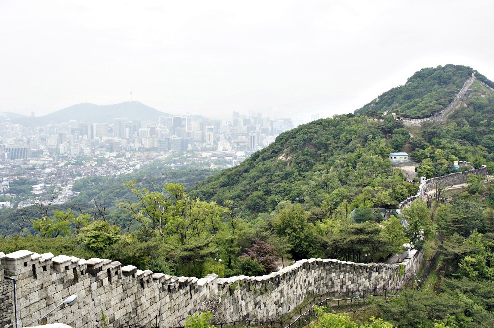
## Description The Seoul Fortress Wall traces the historic boundary of old Seoul, and the Inwangsan section is one of the most compelling short hikes inside the city. Winding stone walls, watchtowers, and narrow ridgelines create a dramatic contrast between rugged natural rock and the modern urban panorama below. Inwangsan (인왕산) itself is a modest peak by elevation, but its steep faces and rocky outcrops make the Fortification route visually striking and surprisingly variable: you pass restored wall segments, crenellated parapets, traditional gates, and quieter stretches where the original stonework blends into pine and ginkgo trees. This route is part walking trail, part living history. Along the Inwangsan section, you can stand at viewpoints that look directly toward Gyeongbokgung Palace and central Seoul, making it a favorite for photographers who want a skyline shot with a distinctly Korean architectural foreground. The combination of natural features and preserved cultural sites gives the trail strong context—archaeologists and local historians point to ritual sites and small petroglyphs on some of the rocky ledges, evidence that the hill has been significant for much longer than the Joseon-era fortifications. For travelers who prioritize accessible day hikes, Inwangsan is practical: the trails are short enough to be combined with a half-day of exploring nearby neighborhoods (Seochon, Buam-dong, or the area around Gyeongbokgung). The experience can feel intimate and unhurried, especially outside popular weekends. For SEO and practical trip planning, search terms that pair well with this route are "Seoul Fortress Wall Inwangsan hike", "Inwangsan panoramic views", and "Seoul city wall trail Gyeongbokgung viewpoint"—phrases locals and travel platforms commonly use. ## Location Inwangsan rises above central Seoul and is most easily accessed on foot from neighborhoods close to Gyeongbokgung Palace and Hyehwa. Nearby subway stations include Gyeongbokgung Station (Line 3) and Hyehwa Station (Line 4); from either point, a 10–25 minute walk brings you to the trailheads depending on your route. Many visitors combine a morning or afternoon at Gyeongbokgung with a short hike up Inwangsan to make efficient use of time. Public transit directions are straightforward: take the subway to Gyeongbokgung or Hyehwa, then follow signs toward the fortress wall trail or ask at local cafes. There are several access points—some are steeper and more direct, others weave through residential lanes and feel more gradual. Maps and local wayfinding often label the path as part of the Seoul City Wall trail network—which helps when using mapping apps or planning a multi-stop day. ## Tips - Hike in the cooler parts of the day: early morning or late afternoon provides the best light for photos and avoids midday crowds and heat. - Wear supportive shoes: some stretches are rocky and uneven; closed-toe hiking shoes or trail runners are recommended. - Bring water and a light snack: although the trail is short, the elevation gain and rocky scrambles benefit from hydration and quick energy. - Be mindful of cultural sites: certain rock ledges and small shrines are used for ritual or prayer—treat them respectfully and avoid disturbing offerings. - Use a map or offline navigation: parts of the trail pass behind residential areas and signage can be minimal; a downloaded map or route screenshot helps. - Combine with nearby visits: pair the hike with a visit to Gyeongbokgung Palace, Seochon’s galleries, or the Buam-dong cafes to make a full half-day itinerary. - Photography tip: for skyline shots with the palace, position yourself on the western-facing viewpoints late in the afternoon for warm light on the stone walls and cool city contrasts. ## Conclusion The Inwangsan section of the Seoul Fortress Wall blends accessible urban hiking with layered history and excellent skyline views. It’s ideally suited for travelers who want a short outdoor escape with high visual return and cultural interest. Whether you pause for a skyline photograph, linger at a watchtower, or simply enjoy the contrast of stone and city, Inwangsan rewards an inquisitive walk and mixes well with central Seoul sightseeing. ## FAQ Q: How long does the Inwangsan trail take? A: Typical loop or ascent routes take 45–90 minutes depending on pace, photo stops, and which trailhead you pick. Q: Is the trail suitable for children or older visitors? A: Many sections are family-friendly, but some parts include short rocky scrambles and steps—evaluate mobility and consider shorter, lower-angle access routes for older visitors. Q: Are parts of the wall restricted or closed at certain times? A: Most sections are open to the public daily, but occasional restoration work or local ceremonies can temporarily limit access—check local signage or community updates. Q: Can I climb on the walls and gates? A: For safety and preservation, avoid climbing on fragile stonework; use designated paths and viewpoints to minimize wear on historic structures. Q: Is there an entrance fee or permit needed? A: No entrance fee—this is a publicly accessible municipal trail and heritage site. ## Links - [Seoul City Wall (Wikipedia)](https://en.wikipedia.org/wiki/Seoul_City_Wall)
GemVoyage Team • World
Seoul
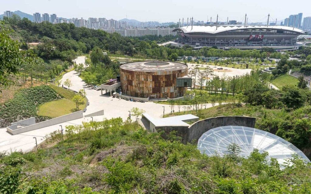
## Description Oil Tank Culture Park is an inventive urban redevelopment project that transforms obsolete oil storage tanks near Hapjeong into a layered cultural complex. The site is notable for its adaptive reuse approach: industrial silos and tanks were structurally preserved and repurposed as galleries, performance spaces, and community areas. The result is a tactile mix of heavy industrial surfaces and light-filled cultural rooms—an atmospheric contrast that frequently features in discussions about sustainable urban design and creative placemaking. Programming at the Oil Tank Culture Park combines curated exhibitions with community-driven activities. The large circular tanks are used for immersive installations and concerts; smaller adjacent spaces host workshops, film screenings, and local markets. The park’s outdoor terraces and green roofs provide vantage points for both the site itself and views across nearby neighborhoods, creating a sequence of experiences that shift between enclosed, resonant tanks and open, landscaped terraces. For visitors interested in architecture, industrial heritage, or contemporary culture, the site offers multiple points of fascination. Preservation choices—retaining the tanks’ raw metal texture, exposing concrete rings, and inserting slender circulation elements—make the site legible as both a former industrial hub and a cultural incubator. The park’s programming often foregrounds sustainability themes, community participation, and experimental performance formats. ## Location The Oil Tank Culture Park is located in Mapo-gu, Seoul, close to Hapjeong station and within walking distance of the World Cup Stadium area. It is well served by subway lines and local buses, and its signage makes it straightforward for international visitors to find. The park is frequently combined in itineraries with nearby Hongdae’s nightlife and Mangwon’s markets. ## Tips - Check the cultural calendar before visiting—special exhibitions and ticketed concerts are common and may require advance booking. - Wear comfortable shoes and expect varying surfaces: pathways range from concrete tank platforms to landscaped terraces. - Bring a light layer for rooftop areas and evening events—the wind can be brisk on exposed terraces. - Combine a visit with nearby Hongdae for dinner or an evening out; the area offers many small restaurants and cafés. - Respect installation boundaries and photography rules within exhibition spaces—some shows restrict flash or tripod use. ## Conclusion Oil Tank Culture Park is a striking example of how industrial heritage can be repurposed into vibrant public culture. It rewards visitors with a mix of dramatic industrial architecture, innovative programming, and a neighborhood-friendly atmosphere—ideal for architecture enthusiasts, cultural explorers, and people who enjoy offbeat urban sites. ## FAQ Q: Are events free? A: Some events and exhibitions are free to the public; larger performances, immersive shows, and special exhibitions may require tickets—check each event’s listing. Q: Is the site wheelchair accessible? A: The park includes ramps and accessible routes, though some older industrial areas may present challenges—contact the venue for detailed accessibility maps. Q: Can I photograph the tanks and installations? A: General photography is usually allowed in public spaces, but specific exhibitions may restrict photography—always check signage or ask staff. Q: Are there food and drink options on-site? A: Occasional pop-up vendors and nearby cafés supply food and drink during events; full-service restaurants are more common in surrounding neighborhoods. Q: Is there parking? A: On-site parking is limited; public transport is the recommended way to visit. ## Links - [Oil Tank Culture Park](https://www.theseoulguide.com/oil-tank-culture-park/)
GemVoyage Team • World
Stockholm
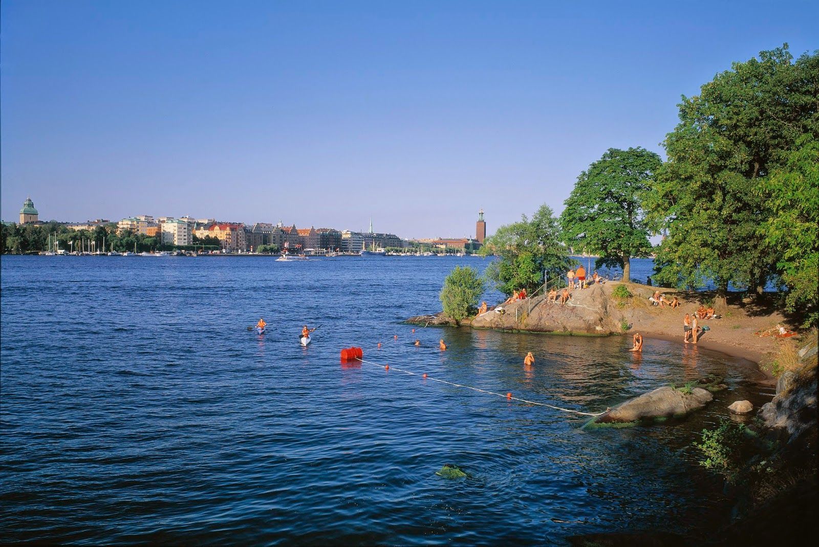
## Description Långholmen Island Beach is one of Stockholm’s most appealing summer spots because it combines waterfront relaxation with the unusual character of an island that has shifted through different uses over time. Visitors come for swimming, sunbathing, walking, and the easygoing atmosphere, but the experience is richer than a simple beach stop. The setting itself is part of the attraction: you are on an island close to the city, surrounded by water, greenery, and reminders of Stockholm’s layered history. What makes Långholmen stand out is that it feels local rather than overly polished. It is a place where residents and visitors mingle in warm weather, where people arrive with towels, picnic food, and a plan to stay for a while. It is not a tropical beach and does not try to be one; instead, it offers a distinctly Scandinavian urban waterfront experience. One lesser-known fact is that Långholmen has had very different historical roles before becoming a leisure destination, which gives the island an added sense of depth. Another interesting detail is that the area’s appeal changes dramatically by season, making it a true summer favorite in a city where outdoor life depends heavily on weather. The beach is also a good example of how Stockholm uses its water environment. Rather than separating city life from the shoreline, the city often integrates swimming and walking areas into the urban fabric. Långholmen captures that idea perfectly. You can spend time on the beach, wander nearby paths, and still feel close to the city center. For travelers, that makes it a convenient and memorable place to balance sightseeing with rest. ## Location Långholmen is a small island in central Stockholm, Sweden, connected to the city by bridges and easy to access from the Södermalm side and other central districts. Because it is so close to the urban core, it is one of the easiest island experiences in Stockholm. The simplest way to get there is by walking from nearby central neighborhoods or using public transport and then continuing on foot. Cycling also works well in Stockholm, and the island fits nicely into a bike-friendly itinerary. Once there, most of the movement is best done on foot so you can enjoy the shoreline and the surrounding green areas at an unhurried pace. ## Tips This is best visited in warm weather, especially in late spring and summer. Bring swimwear if you want to use the beach properly, but also bring a layer for cooler winds. Combine the visit with a walk around the island so you see more than just the main swimming area. Arrive earlier on sunny days if you want a quieter spot near the water. ## Conclusion Långholmen Island Beach is a relaxed city escape that gives Stockholm a rare but very welcome summer beach mood. ## FAQ ### Is Långholmen a real beach? Yes, though it is a city beach rather than a large natural seaside beach. ### Is it good for swimming? Yes, it is one of Stockholm’s popular places for summer swimming. ### How do I get there from central Stockholm? Walk, bike, or use public transport and then cross to the island on foot. ### Is it busy in summer? It can be, especially on warm weekends and sunny afternoons. ### Can I visit outside summer? Yes, but it is most enjoyable as a beach destination in the warmer months. ## Links - [Stockholm official visitor information](https://www.visitstockholm.com/) - [Långholmen on Wikipedia](https://en.wikipedia.org/wiki/Långholmen)
GemVoyage Team • World
Lisbon
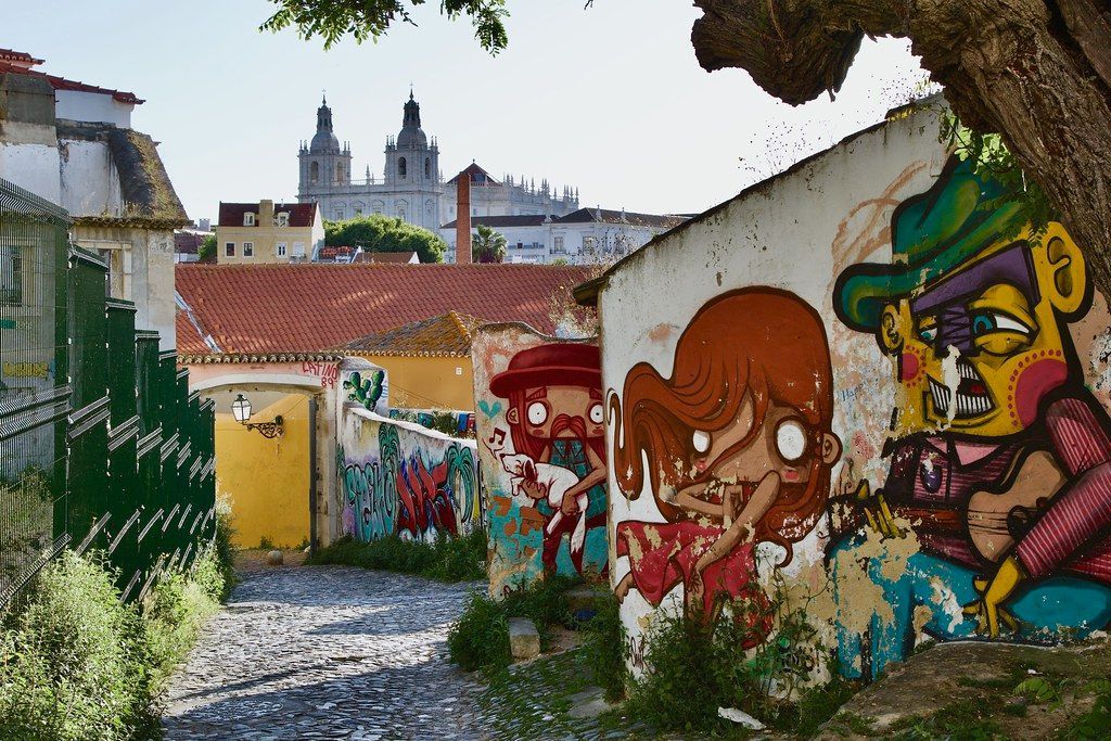
## Description Graça is a quintessential Lisbon neighborhood perched above the Alfama and Mouraria districts, cherished for sweeping viewpoints, cobbled streets, and an atmosphere that feels both distinctly historic and quietly local. Visitors come to Graça for the Miradouro da Senhora do Monte and Miradouro de São Pedro de Alcântara — panoramic terraces offering some of the city’s most dramatic vistas of terracotta roofs, the Tagus River, and the São Jorge Castle. What makes Graça special is its blend of everyday Lisbon life with pockets of bohemian charm: small cafes, traditional tascas (local eateries), and street art woven into centuries-old façades. Graça is less polished than some tourist centers; that authenticity is precisely its draw. Little-known facts: Graça was historically where sailors and workers lived, and it hosts several small chapels and hidden gardens that date back to medieval times. Also, the neighborhood holds an annual neighborhood festival (festa) with music, street food, and community events that offer an intimate cultural experience rarely encountered by tourists. Wandering Graça, you’ll encounter artisanal shops, small antiques dealers, and local markets offering fresh produce. The pace is leisurely, inviting visitors to slow down, sample pastéis de nata in a local bakery, and experience everyday Portuguese life away from main tourist arteries. ## Location Graça sits on one of Lisbon’s seven hills in central Portugal, within the parish of Graça and close to historic districts such as Alfama and Mouraria. The neighborhood is easily reached on foot from Baixa or by tram 28, one of Lisbon’s most iconic routes that passes nearby. Getting there: Take tram 28 for a scenic approach, but be cautious of pickpockets on crowded trams. Alternatively, the Glória or Bica funiculars bring you near central viewpoints; buses and taxis are frequent. Walk from Baixa (central Lisbon) for a rewarding uphill stroll, and use comfortable shoes due to the steep, cobbled streets. ## Tips - Visit viewpoints at sunrise or sunset for the best light and smaller crowds. - Explore side streets away from the main miradouros to find quiet cafes and authentic eateries. - Bring a map or use offline navigation — narrow alleys can be maze-like, and cell service can be spotty in tight lanes. - Wear comfortable, grippy shoes because cobblestones and steep streets can be slippery, especially when wet. - Try regional snacks at neighborhood tascas and ask locals for recommended dishes. - Attend a local “festa” if your visit coincides with one; it’s a rare chance to experience community Lisbon culture. ## Conclusion Graça offers an intimate, lightly touristed version of Lisbon: dramatic views, historical layers, and a genuine neighborhood feel. It rewards slow exploration with authentic encounters and unforgettable vistas. ## FAQ Q: Is Graça safe for tourists? A: Yes, Graça is generally safe; normal precautions apply, especially in crowded tram or tourist spots. Q: Are there restaurants in Graça? A: Yes — small tascas, cafes, and a few modern eateries serve local Portuguese cuisine. Q: Can I walk from Baixa to Graça? A: Yes, but expect steep climbs; allow time and wear comfortable footwear. Q: Are the miradouros wheelchair accessible? A: Some viewpoints have limited accessibility — check specific miradouro access beforehand. ## Links - [Lisbon tourism site (general info)](https://www.visitlisboa.com)
GemVoyage Team • World
Hurghada
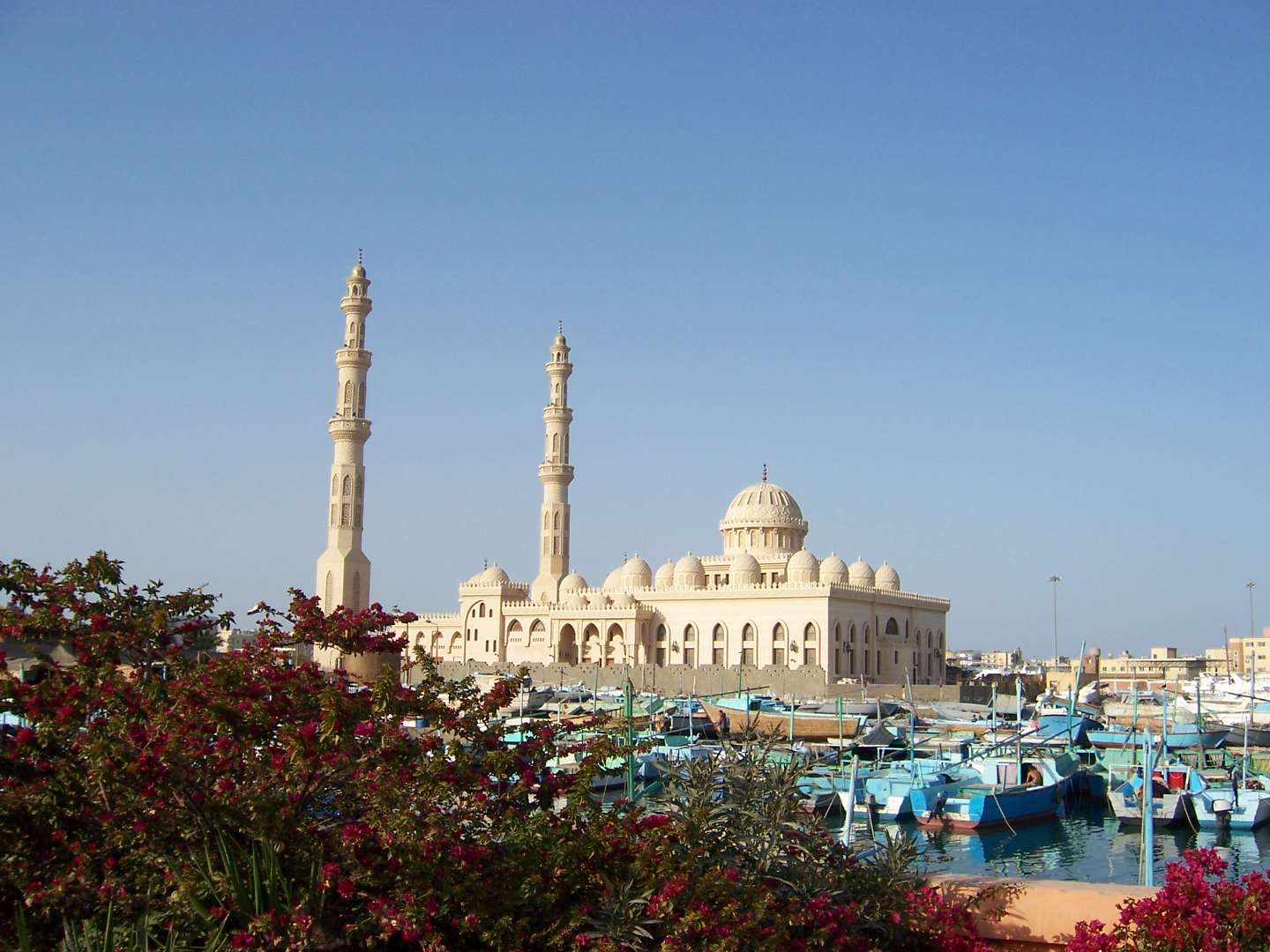
## Description Al Mina Mosque, also known as El Mina Masjid or the Grand Mosque of Hurghada, is one of the most striking religious landmarks on Egypt’s Red Sea coast. Completed in 2012, this architectural gem blends traditional Islamic design with modern elegance, making it a must-see for visitors seeking cultural depth beyond the beaches and resorts. With its gleaming white marble façade, towering minarets, and intricately carved domes, the mosque stands as a symbol of spiritual devotion and artistic craftsmanship. The mosque features two minarets that rise 40 meters into the sky and a central dome that reaches 25 meters in height. Inside, visitors are greeted by a serene prayer hall adorned with ornate chandeliers, engraved walls, and geometric patterns that reflect centuries of Islamic art. The mosque can accommodate up to 10,000 worshippers, making it the largest in the Red Sea Governorate. A little-known fact: Al Mina Mosque was built on an 8,000-square-meter site adjacent to Hurghada’s harbor, and its name—“Al Mina”—translates to “The Port,” referencing its proximity to the sea. The mosque also houses an Islamic cultural center that offers lectures and educational materials in multiple languages, aimed at fostering interfaith understanding and dialogue. ## Location Al Mina Mosque is located in **Egypt**, in the **Red Sea Governorate**, within the **city of Hurghada**. It sits directly on the waterfront near the Hurghada Marina and the city’s main harbor, making it easily accessible from both the old town (El Dahar) and the newer resort areas. ### How to Get There - **By Taxi**: Taxis are readily available throughout Hurghada and can take you directly to the mosque entrance. - **By Foot**: If you’re staying near the Marina or Sheraton Road, the mosque is within walking distance. - **By Tour**: Many city tours include a stop at Al Mina Mosque, often paired with visits to local markets and cultural sites. - **By Public Transport**: Minibuses and shared taxis frequently pass through the area, though they may require some navigation. Its central location makes it an ideal stop during a day of sightseeing or evening stroll along the harbor. ## Tips - **Visit Outside Prayer Times**: Non-Muslim visitors are welcome to explore the mosque during non-prayer hours. Avoid visiting during Friday prayers or religious holidays. - **Dress Modestly**: Women should cover their hair, shoulders, and knees. Men should avoid shorts. Scarves and robes may be provided at the entrance. - **Photography**: While exterior photography is encouraged, ask permission before taking photos inside, especially during prayer times. - **Respect the Space**: This is an active place of worship. Maintain a quiet and respectful demeanor. - **Combine with Nearby Attractions**: After visiting the mosque, explore the Hurghada Marina, local bazaars, or enjoy a meal at one of the waterfront restaurants. - **Check for Cultural Events**: The mosque’s Islamic center occasionally hosts lectures and exhibitions open to the public. ## Conclusion Al Mina Mosque is a serene and visually stunning destination that offers a glimpse into Egypt’s Islamic heritage. With its majestic architecture, peaceful ambiance, and central location, it’s a rewarding stop for anyone exploring Hurghada beyond the beach. ## FAQ **1. What are the opening hours of Al Mina Mosque?** The mosque is open daily from 9:00 AM to 5:00 PM, except during prayer times. **2. Is there an entrance fee?** No, entry is free. Donations to the mosque or its cultural center are welcome but not required. **3. Can non-Muslims visit the mosque?** Yes, non-Muslims are welcome during non-prayer hours and are encouraged to learn about the mosque’s history and architecture. **4. Is the mosque wheelchair accessible?** Yes, the mosque has ramps and accessible entrances for visitors with mobility needs. **5. Are guided tours available?** Some local guides offer cultural tours that include the mosque. The Islamic center also provides multilingual materials and lectures. **6. Is it safe to visit the mosque with children?** Yes, families are welcome. Children should be supervised and respectful of the prayer areas. ## Links - [Al Mina Mosque Visitor Guide – Hurghada Day](https://hurghadaday.com/things-to-do/al-mina-mosque/)
GemVoyage Team • World

Comments