GemVoyage Team • World
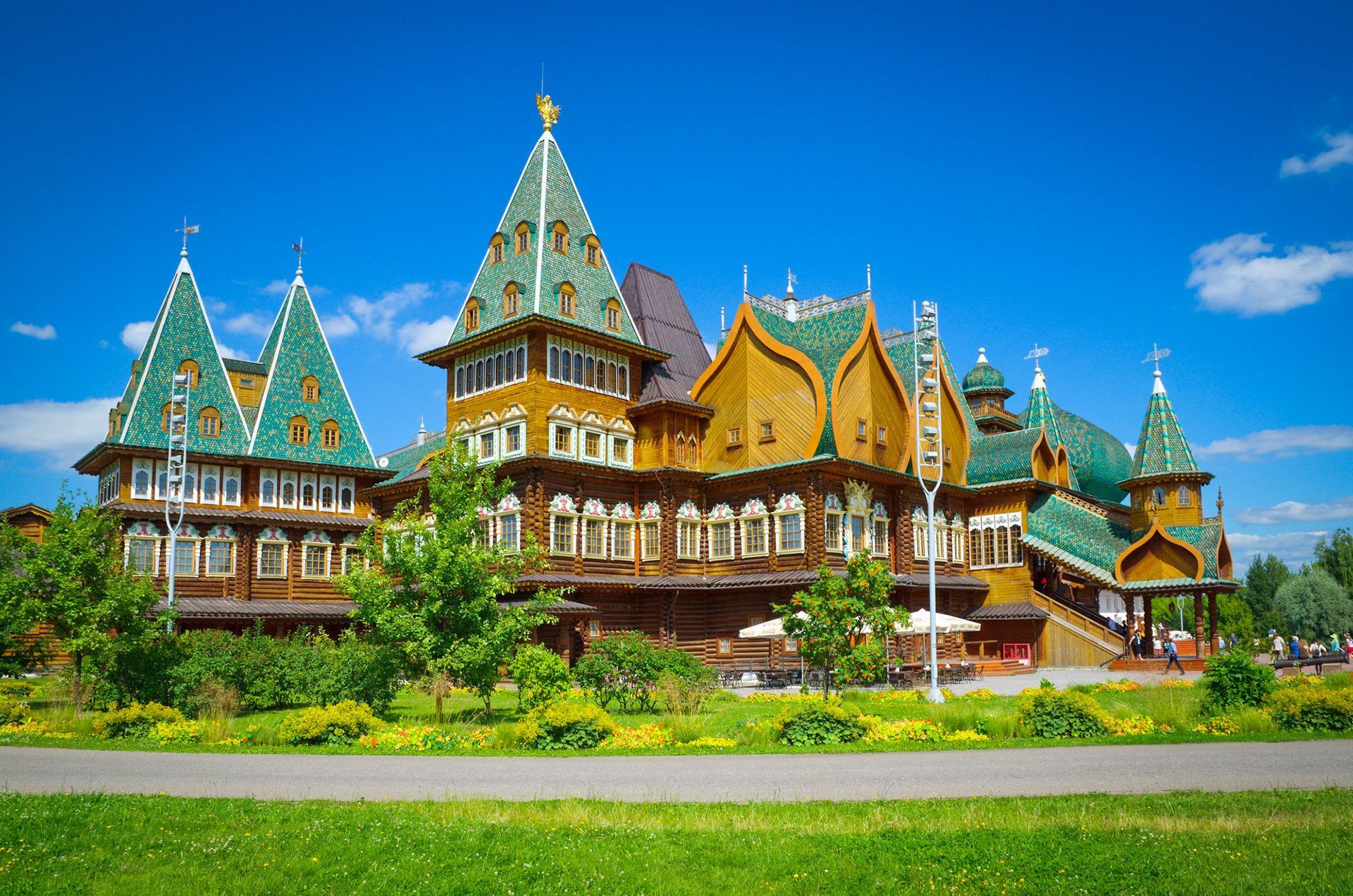
What makes Kolomenskoye especially impressive is its historical depth. The estate was associated with Russian rulers for centuries and functioned as a place of retreat, ceremony, and seasonal residence. One of its most famous features is the Church of the Ascension, a striking landmark that is widely recognized for its architectural importance. A lesser-known fact is that the park’s broader grounds include not only monuments but also reconstructed wooden structures that help visitors imagine how Russian domestic and court life might have looked in earlier periods. Another detail that often surprises travelers is how strongly the place changes with the seasons: spring blossoms, summer greenery, autumn color, and winter snow each give the site a different personality.
For travelers, Kolomenskoye is appealing because it offers a very Moscow-specific balance. The city is often experienced as large, dense, and fast-moving, but here you get a more spacious and contemplative side. You can walk along the river, explore heritage buildings, pause by old orchards, and enjoy the sense that the city opens outward rather than compressing inward. It is a particularly strong choice for visitors who want historical context without spending the whole day indoors.
The park also works well as an antidote to more crowded attractions. It provides room to breathe, which is especially valuable in a city as large and energetic as Moscow.
The easiest way to get there is by Moscow Metro, followed by a short walk depending on your chosen entrance. Metro access is usually the most efficient approach for visitors, especially because surface traffic can be slow in a city this large. Once inside, the site is best explored on foot. If you want a smoother visit, start with the main landmarks and then move toward the quieter natural sections.
Because Kolomenskoye is both a park and a heritage site, it is wise to think of it as a destination for a full outing rather than a quick stop. You can spend a couple of hours there comfortably, and more if you enjoy architecture, photography, or leisurely walks.
Check the weather before you go. Kolomenskoye can be beautiful in any season, but the experience changes dramatically with conditions, so planning around sunshine or a clear winter day is smart.
Do not limit yourself to the best-known monument. The open spaces, orchard areas, and river views are part of what makes the site special.
Take your time with the architecture. The historical buildings are more meaningful when you understand their place in Russian royal history.
If possible, pair the visit with a meal or snack nearby so you can turn the park into a half-day excursion instead of a rushed check-in.
Discover more hidden gems you might love.
Armenia
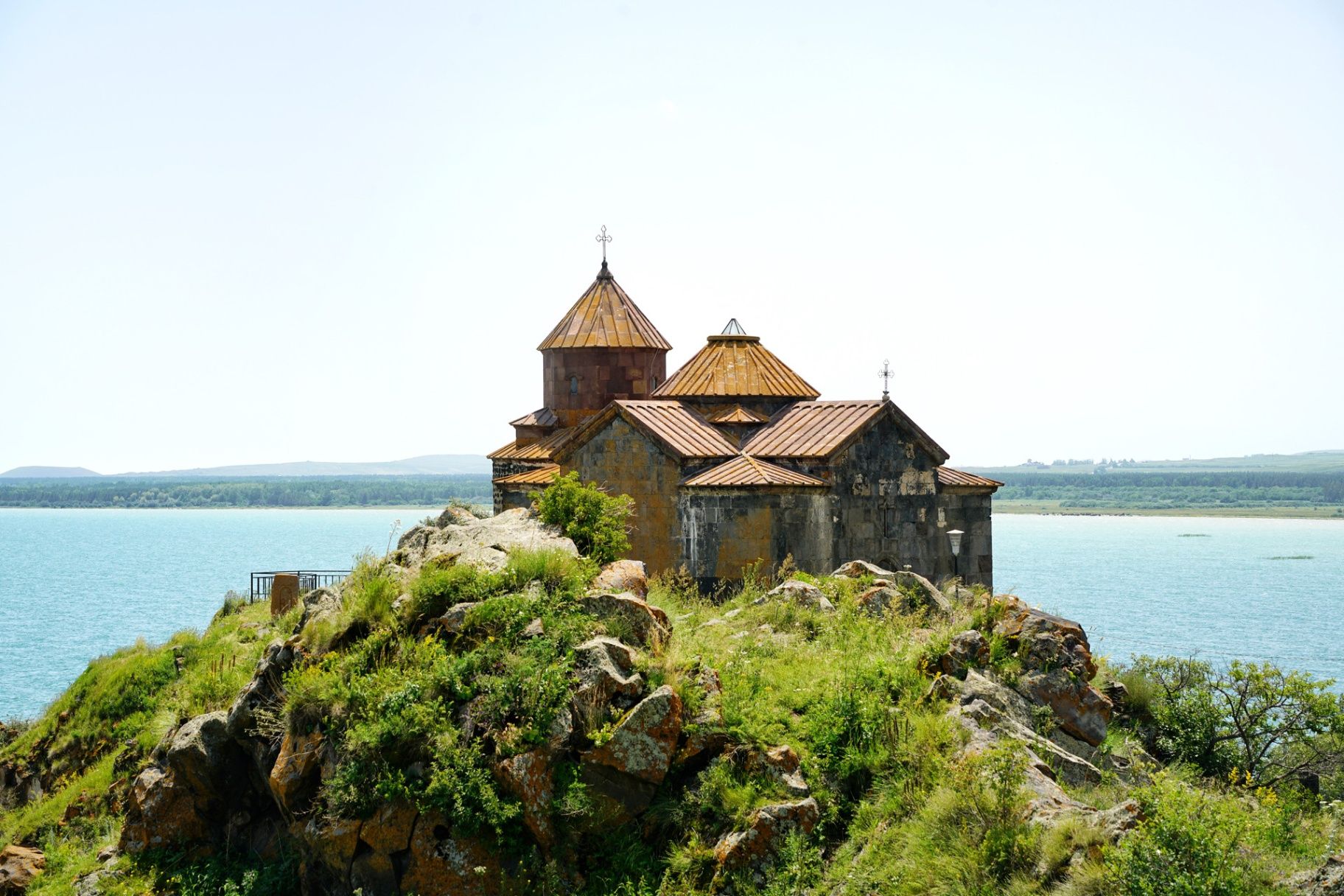
## Description **Hayravank Monastery (Հայրավանք վանք)** is a striking medieval complex overlooking the turquoise waters of **Lake Sevan** in **Armenia**. Modest in size yet monumental in spirit, this 9th–12th century monastery embodies the timeless harmony between Armenian architecture, nature, and spirituality. The complex consists of a **church, a chapel, and a gavit (narthex)**, all built from dark volcanic tuff that glows deep red and orange under the sunlight. Though simple in design, its craftsmanship reveals the hallmarks of Armenian medieval architecture: cross-domed layouts, intricately carved khachkars (stone crosses), and an unpretentious yet deeply spiritual atmosphere. What makes Hayravank truly special is its **breathtaking location**—perched on a rocky cliff directly above Lake Sevan, it offers sweeping views of the surrounding mountains and shimmering water below. At sunrise or sunset, the combination of ancient stone and glowing lake light creates a scene that feels almost otherworldly. A lesser-known fact is that local legend claims the monastery once housed a **magical library of sacred scrolls**, guarded by a wise monk who vanished mysteriously. Archaeologists have indeed found early manuscripts and stone inscriptions on-site, adding intrigue to this ancient story. Another fascinating aspect is that Hayravank’s design likely influenced later monasteries in the Sevan basin, helping shape Armenia’s architectural identity. ## Location Hayravank Monastery is located in **Gegharkunik Province**, on the **western shore of Lake Sevan** in **Armenia**. It lies near the village of **Hayravank**, approximately **120 kilometers northeast of Yerevan** and **20 kilometers north of Sevan town**. To get there: * **By car:** From Yerevan, take the M4 highway toward Sevan and continue along the lakeside road to Hayravank village. The drive takes about **2–2.5 hours** and is both scenic and well-paved. * **By bus or taxi:** Shared minibuses (marshrutkas) run from Yerevan to Sevan, where taxis can then take you directly to the monastery. * **By tour:** Many Lake Sevan day tours include Hayravank along with Noratus Cemetery and Sevanavank Monastery. Its lakeside setting makes it easy to combine a cultural visit with a picnic or a walk along the shore. ## Tips * **Best time to visit:** Late spring to early autumn (May–October) offers pleasant weather and clear lake views. * **Photography:** Bring a wide-angle lens — the lake backdrop and the monastery’s silhouette at sunset are spectacular. * **Dress respectfully:** As an active religious site, modest clothing is appreciated. * **Explore nearby:** Combine your visit with **Noratus Cemetery**, famous for its medieval khachkars, or with **Sevanavank Monastery** for a complete historical experience. * **Avoid windy days:** Lake Sevan’s altitude (1,900 m) can make the area windy and cool, even in summer — bring a light jacket. * **Ask locals for stories:** Villagers often share legends about the site, from hidden treasures to mysterious monks who once lived there. ## Conclusion **Hayravank Monastery** is a masterpiece of simplicity, serenity, and natural beauty — a place where Armenia’s spiritual heritage meets the grandeur of its landscapes. With its ancient walls set against the endless blue of Lake Sevan, it stands as a quiet yet powerful reminder of the country’s medieval faith and craftsmanship. For travelers seeking peace, history, and authentic Armenian charm, Hayravank is a destination that captures the soul of the nation itself. ## FAQ **1. When was Hayravank Monastery built?** The main church dates to the **9th century**, with additional structures, including the gavit, added in the **12th century**. **2. Is the monastery still active?** It is not a full-time monastic residence but is used for religious ceremonies and services on special occasions. **3. Do I need to pay an entrance fee?** No, entrance to Hayravank Monastery is **free of charge**. **4. How long should I plan to stay?** Allow about **30–45 minutes** to explore the complex, take photos, and enjoy the lake views. **5. Is it accessible year-round?** Yes, though winter visits can be chilly due to snow and wind. Roads are usually passable except during heavy weather. **6. Are there restaurants or facilities nearby?** There are small cafés and picnic spots near the village of Hayravank and along Lake Sevan’s western shore. ## Links * [Armenia Tourism Official Site](https://armenia.travel) * [Armenian Monasteries – Cultural Heritage](https://www.armeniapedia.org/wiki/Hayravank_Monastery)
GemVoyage Team • World
Milan
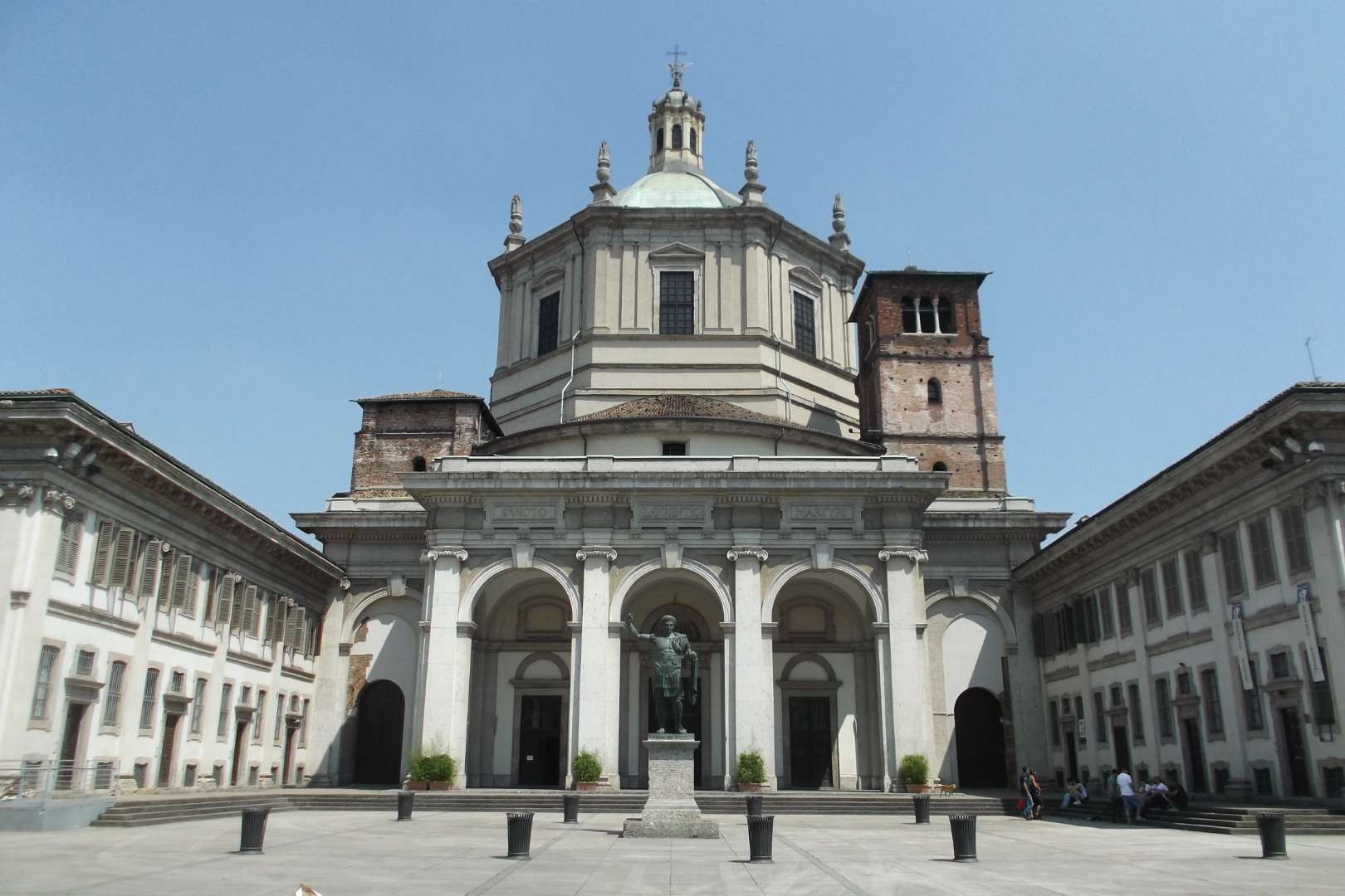
## Description The Basilica of San Lorenzo Maggiore in Milan is one of the city’s oldest and most architecturally intriguing churches, offering a rich tapestry of history, religion, and design. Originally constructed between the late 4th and early 5th centuries, the basilica has undergone numerous reconstructions, resulting in a unique blend of Early Christian, Renaissance, and Baroque styles. Its imposing central dome and symmetrical layout make it a standout among Milan’s ecclesiastical landmarks. What sets San Lorenzo apart is its daring architectural originality. Art historians have noted its resemblance to the great churches of Constantinople, many of which no longer exist. The basilica’s interior features elegant marble columns, intricate mosaics, and the stunning Chapel of Saint Aquilino, which houses 4th-century Byzantine mosaics and remnants of Roman construction materials. Outside, the Colonne di San Lorenzo—sixteen Roman columns dating from the 3rd century—stand as a dramatic prelude to the church and are among the few surviving relics of ancient Mediolanum. A little-known fact: archaeological investigations suggest that the basilica may have been built atop a Roman amphitheater, and some of its foundational materials were repurposed from other Roman sites. Another fascinating detail is that the basilica’s dedication to Saint Lawrence was only confirmed in 590 AD, long after its initial construction. ## Location The Basilica of San Lorenzo Maggiore is located in **Italy**, in the **Lombardy region**, within the **city of Milan**. Its exact address is **Corso di Porta Ticinese, 39**, situated near the medieval Porta Ticinese and within walking distance of the Navigli district and the city center. ### How to Get There - **By Metro**: Take Line M2 to Sant’Ambrogio or Line M3 to Missori, then walk about 10–15 minutes. - **By Tram**: Tram line 3 stops at “Ticinese Molino delle Armi,” just steps from the basilica. - **By Foot**: From the Duomo, it’s a pleasant 15-minute walk through historic streets. - **By Bike or Scooter**: Milan’s bike-sharing and e-scooter services offer a scenic and efficient way to reach the basilica. Its central location makes it easy to include in a day of sightseeing, especially when paired with nearby attractions like the Basilica of Sant’Eustorgio or the Navigli canals. ## Tips - **Visit the Chapel of Saint Aquilino**: Don’t miss this side chapel, which contains some of the oldest mosaics in Milan and offers a glimpse into the city’s Roman past. - **Go Early or Late**: The basilica is less crowded in the morning or late afternoon, allowing for a more peaceful visit. - **Dress Modestly**: As with all religious sites, respectful attire is recommended. - **Explore the Piazza**: The square in front of the basilica is lively and atmospheric, often filled with street performers and locals. - **Check for Mass Times**: If you’re interested in attending a service, consult the basilica’s schedule in advance. - **Photography**: Photos are allowed, but avoid flash and be mindful during services. ## Conclusion Basilica San Lorenzo Maggiore is a captivating blend of ancient history and spiritual heritage. With its Roman columns, Byzantine mosaics, and architectural grandeur, it offers a compelling experience for anyone exploring Milan’s rich cultural landscape. ## FAQ **1. Is there an entrance fee to visit the basilica?** No, entry to the basilica is free. Donations are welcome. **2. What are the opening hours?** Monday to Friday: 8:00 AM – 12:30 PM and 3:00 PM – 6:30 PM Saturday and Sunday: 9:00 AM – 1:00 PM and 3:00 PM – 7:00 PM **3. Can non-Catholics visit the basilica?** Yes, the basilica is open to all visitors, regardless of religious background. **4. Is the basilica wheelchair accessible?** Some areas may be challenging due to steps and uneven flooring, but the main entrance and nave are generally accessible. **5. Are guided tours available?** Yes, some local tour operators include San Lorenzo in their walking tours of Milan’s historic center. **6. What is the best time of year to visit?** Spring and autumn offer mild weather and fewer crowds, making them ideal for sightseeing. ## Links - [Basilica of San Lorenzo – Wikipedia Overview](https://en.wikipedia.org/wiki/Basilica_of_San_Lorenzo,_Milan) - [San Lorenzo Maggiore – Official Website](http://www.sanlorenzomaggiore.com/)
GemVoyage Team • World
Shkodër
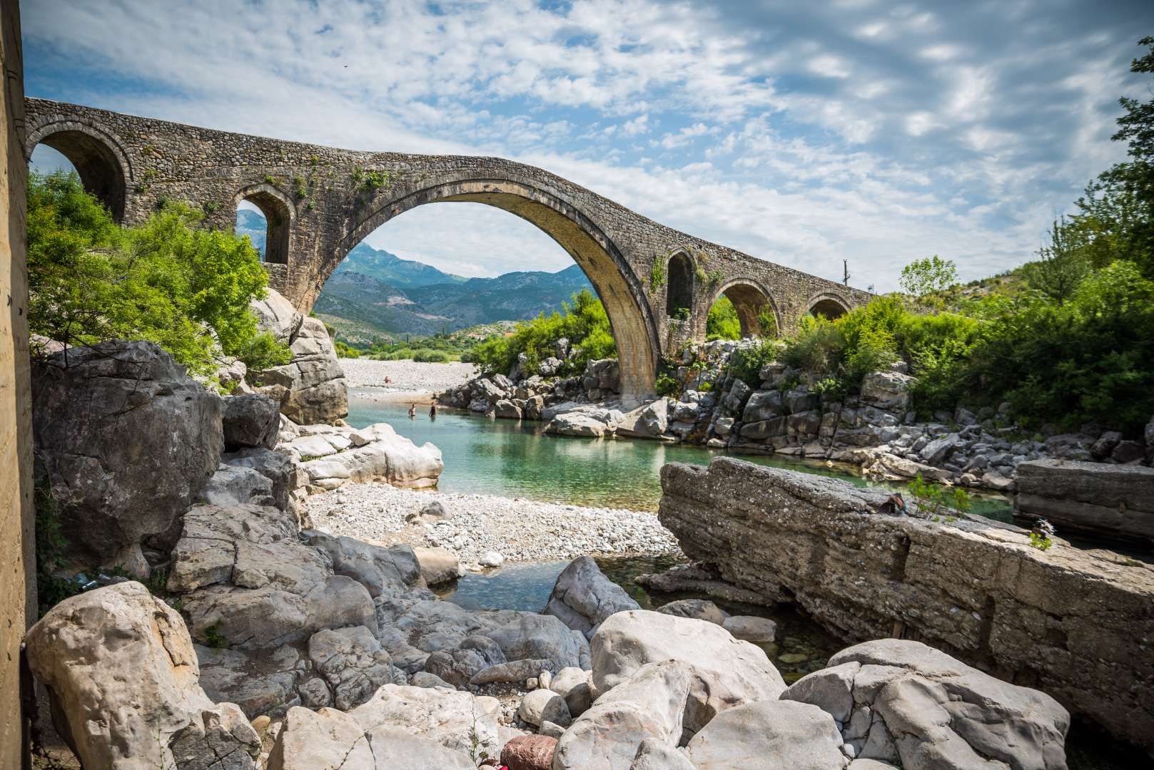
## Description Mesi Bridge (Ura e Mesit), an 18th-century Ottoman-era stone bridge, is one of Albania’s most captivating historical landmarks. Located near the city of Shkodër, this architectural gem spans the Kir River with a graceful series of 13 arches, stretching 108 meters in length. Built around 1770 by Kara Mahmud Bushati, a powerful Ottoman pasha, the bridge was part of a strategic infrastructure project to connect Shkodër with the northern highlands, including the medieval town of Drisht. What makes Mesi Bridge unique is its asymmetrical design and the craftsmanship of its construction. The bridge was built in two phases: the central arch and one adjacent arch were completed first, followed by the remaining eleven. The structure features round river stones and chiseled stone plates, giving it both strength and aesthetic charm. Despite centuries of wear and occasional flooding, the bridge remains remarkably well-preserved and is considered the largest and best-preserved Ottoman bridge in Albania. A little-known fact is that the bridge once formed part of a trade route that extended all the way to Pristina, Kosovo. Another intriguing detail is that the English artist Edward Lear sketched the bridge during his travels in Albania in 1848, captivated by its elegance and the surrounding landscape. ## Location Mesi Bridge is located in **Albania**, in the **Shkodër County**, near the **city of Shkodër**. Specifically, it sits in the village of **Mes**, approximately 5 to 8 kilometers northeast of the city center. ### How to Get There - **By Car**: The most convenient way to reach Mesi Bridge is by car. From Shkodër, follow the road toward the village of Mes. The route is well-marked and passes through scenic countryside. - **By Taxi**: Taxis from Shkodër are affordable and can take you directly to the bridge. - **By Bicycle**: Adventurous visitors can enjoy a leisurely bike ride along quiet rural roads. - **By Public Transport**: Options are limited, so planning ahead is recommended if you’re not driving. The journey itself is part of the experience, offering views of lush greenery, distant mountains, and traditional Albanian villages. ## Tips - **Visit in Spring or Early Summer**: The surrounding landscape is at its most vibrant, and water levels in the Kir River are ideal for photography. - **Wear Comfortable Footwear**: The bridge’s surface is uneven, and exploring nearby trails requires sturdy shoes. - **Bring Water and Sun Protection**: Especially in summer, temperatures can be high and shade is limited. - **Explore Nearby Sites**: Combine your visit with a trip to Drisht Castle or a walk along the Kir Valley. - **Photography**: Early morning or late afternoon offers the best lighting for capturing the bridge and its surroundings. - **Respect the Site**: Though open to the public, the bridge is a protected cultural monument. Avoid climbing on fragile sections. ## Conclusion Mesi Bridge is a stunning example of Ottoman engineering and Albanian heritage. With its elegant arches, historical significance, and picturesque setting, it offers visitors a peaceful and enriching escape just outside Shkodër. ## FAQ **1. Is there an entrance fee to visit Mesi Bridge?** No, the site is free to visit. **2. Can I swim in the Kir River near the bridge?** Yes, swimming is possible, especially in spring and early summer. Water levels may be low in July and August. **3. Is the bridge accessible year-round?** Yes, but heavy rains in winter may make the area muddy or slippery. **4. How long should I plan for the visit?** A visit typically takes 1–2 hours, including time for photos and exploring the surroundings. **5. Is Mesi Bridge suitable for children?** Yes, but supervision is recommended due to uneven surfaces and proximity to the river. **6. Are guided tours available?** Local guides in Shkodër may offer tours that include Mesi Bridge and nearby historical sites. ## Links - [Mesi Bridge – Wikipedia Overview](https://en.wikipedia.org/wiki/Mesi_Bridge) - [VisitShkodër – Mesi Bridge Guide](https://visitshkoder.org/mesi-bridge/)
GemVoyage Team • World
Cape Town
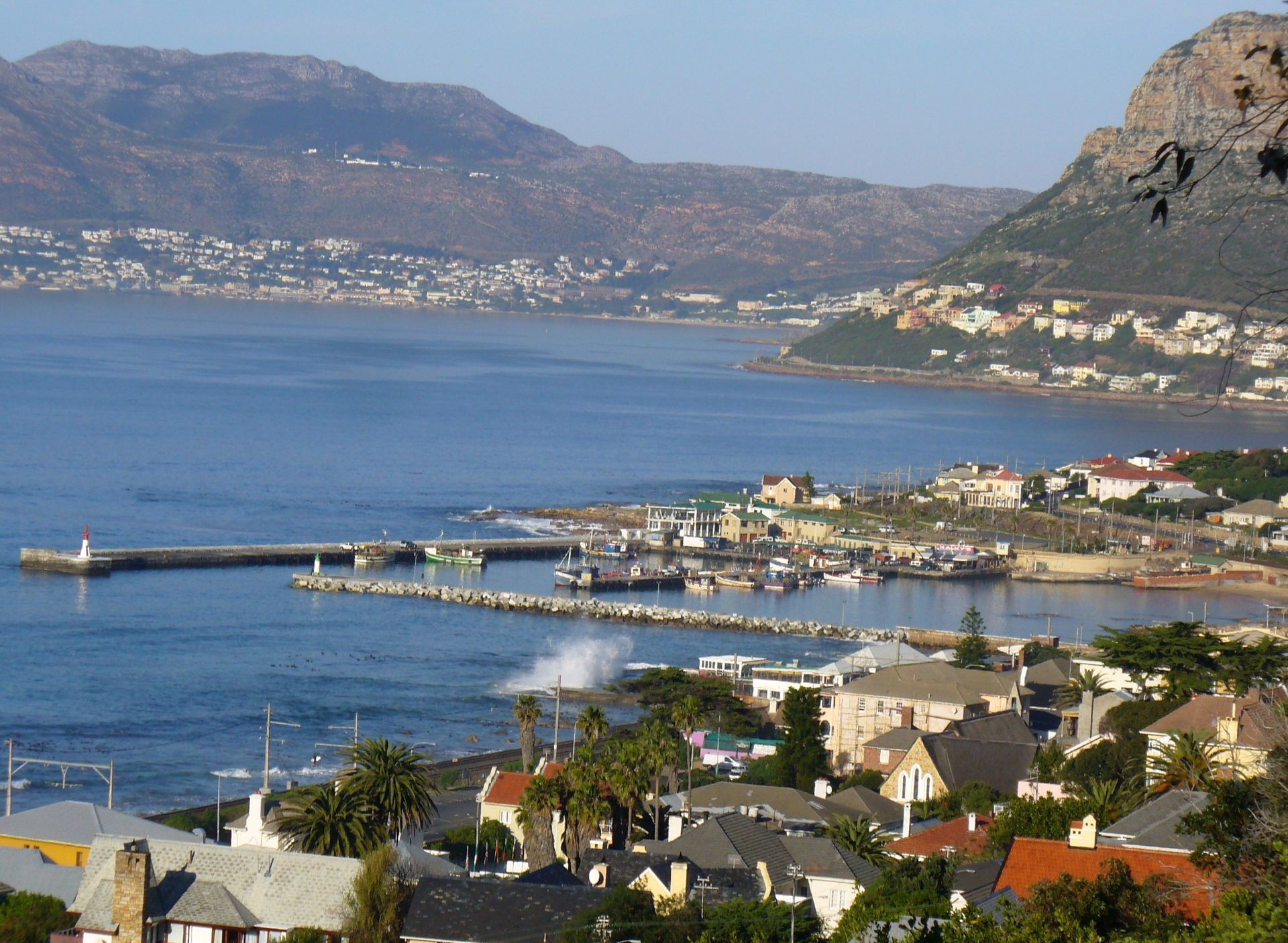
## Description Kalk Bay Harbour is one of those places that feels immediately alive. It is not a polished waterfront designed only for visitors, and that is exactly what makes it memorable. Fishing boats still work the water, gulls circle over the quays, and the rhythm of the harbor changes with the tides, the weather, and the catch of the day. In Cape Town, where many visitors focus on Table Mountain or the Atlantic coast, Kalk Bay offers a more intimate coastal experience. It is a place where everyday life and scenic charm overlap naturally. The harbor sits in the old fishing village of Kalk Bay, so the atmosphere is layered with history. Narrow streets, weathered buildings, small seafood spots, and the smell of the sea give the area a lived-in feel that is harder to find in more developed tourist precincts. One little-known detail is that Kalk Bay has long been associated with the Kalk Bay fishing community, whose routines still shape the harbor today. Another is that the surrounding bay often changes character dramatically within a few hours, which makes return visits rewarding because the light and water are rarely the same twice. What makes the harbor especially appealing is how many different experiences it offers in one compact area. You can watch fishing activity in the morning, stroll the quayside, browse nearby shops, and then settle in for coffee or seafood with views across False Bay. For travelers who like places that feel authentic rather than staged, Kalk Bay Harbour is a strong choice. It is scenic, but it is also practical, working, and slightly unpredictable. That mix gives it real personality. The harbor is also a useful place to slow down. Cape Town can be full of high-energy sightseeing, but Kalk Bay encourages a different pace. Visitors tend to linger, looking at boats, reading the sea, or simply sitting and watching local routines unfold. Even if you stay only an hour, the harbor leaves a strong impression because it feels like a slice of Cape Town that still belongs primarily to the people who live and work there. ## Location Kalk Bay Harbour is located in Kalk Bay, on the False Bay coast of Cape Town, in the Western Cape province of South Africa. The harbor sits south of the central city area, along the scenic coastal road that links the southern suburbs with Simon’s Town and the Cape Peninsula. It is easy to combine with a broader day trip through Muizenberg, St James, and the rest of the False Bay shoreline. The most practical way to reach it is by car, ride-hailing service, or by taking the Southern Line train and continuing on foot from Kalk Bay station. The walk from the station is short and pleasant, and it helps you arrive already tuned into the neighborhood’s slow coastal rhythm. If you are planning to explore several nearby stops, driving gives you the most flexibility, but parking can be tighter at busier times, especially on weekends and during holiday periods. If you are coming from central Cape Town, expect the journey to take roughly 30 to 45 minutes depending on traffic. Morning and late-afternoon visits are often best because the light is more dramatic and the harbor is especially active. The area is also accessible from other popular southern suburbs, so it works well as part of a larger False Bay outing rather than as a standalone destination. ## Tips - Go early if you want to see the harbor at its liveliest. Morning is when fishing activity is most noticeable and the atmosphere feels most local. - Bring a light jacket even on warm days. The sea breeze can be stronger than you expect, especially near the water’s edge. - Allow time to wander beyond the harbor itself. The surrounding streets and nearby coastline are part of the experience, not just the quayside. - Keep your camera ready, but do not rush the visit. The harbor rewards slow observation more than quick snapshots. - If you are planning to eat nearby, check opening hours in advance. Small coastal businesses may operate on schedules that differ from larger city restaurants. ## Conclusion Kalk Bay Harbour is a compact but deeply atmospheric stop in Cape Town, combining working coastal life, scenic views, and a strong sense of place. It is ideal for travelers who want a harbor that feels real, local, and full of character rather than overly curated. ## FAQ ### Is Kalk Bay Harbour worth visiting if I only have a short time in Cape Town? Yes. Even a short visit gives you a clear sense of the area’s character. You can watch the boats, walk the harbor edge, and experience a very different side of Cape Town from the usual landmark circuit. ### What is the best time of day to visit? Morning is usually best if you want to see the harbor working at full speed. Late afternoon is also attractive because the light softens over False Bay and the atmosphere becomes quieter. ### Can I visit Kalk Bay Harbour without a car? Yes. The train to Kalk Bay station is a practical option, followed by a short walk. Ride-hailing services are also convenient if you want a simpler door-to-door trip. ### Is the area around the harbor safe for walking around? Like any busy urban coastal area, it is best to stay aware of your surroundings, especially when it is crowded. During the day, the harbor and nearby streets are generally visited by many people and are easy to explore at a relaxed pace. ## Links - [Cape Town tourism](https://www.capetown.travel/) - [Kalk Bay on Wikipedia](https://en.wikipedia.org/wiki/Kalk_Bay)
GemVoyage Team • World
Tanzania
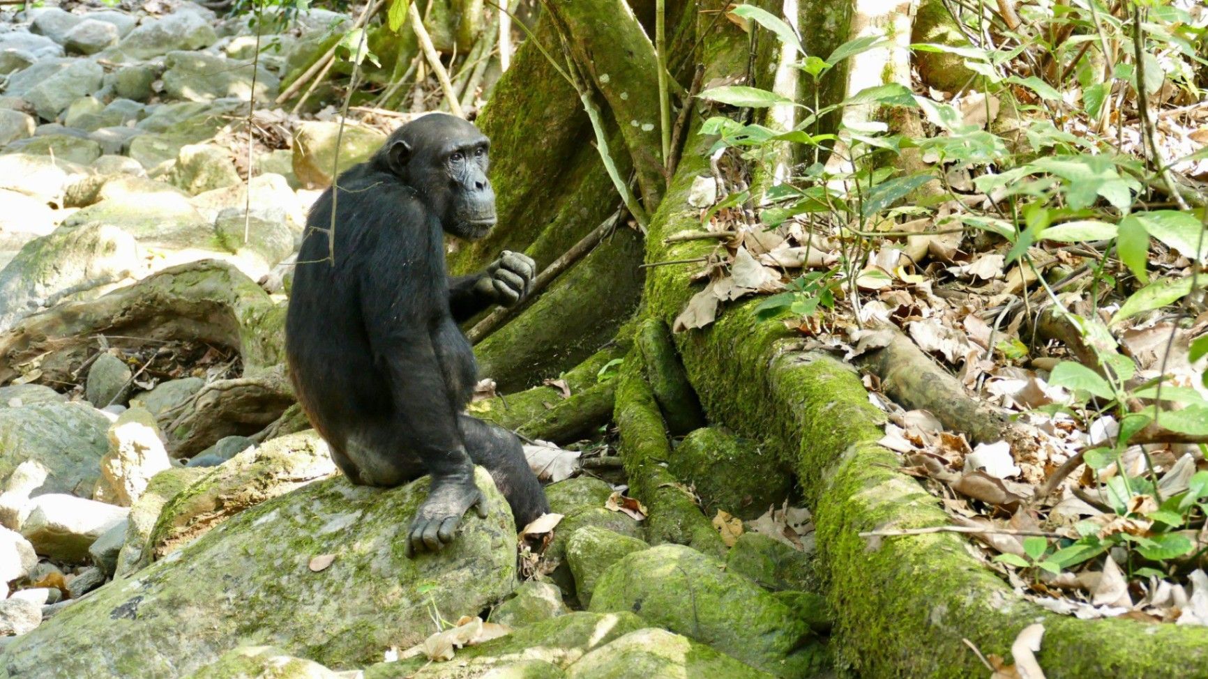
## Description Nestled on the remote eastern shores of **Lake Tanganyika**, the **Mahale Mountains National Park** is one of **Tanzania’s most untouched and magical wilderness areas**. Famous for its **wild chimpanzee population**, pristine forests, and turquoise waters, this park offers an experience unlike any other in Africa — where jungle-clad mountains meet one of the world’s oldest and deepest lakes. Covering over **1,600 square kilometers**, Mahale Mountains National Park lies at the crossroads of **rainforest, savanna, and miombo woodland**, creating a spectacularly diverse ecosystem. Its landscape is dominated by the dramatic **Mahale Mountain Range**, with **Mount Nkungwe** — the highest peak — rising to 2,462 meters above sea level. The park is most renowned for being home to one of the **largest known communities of wild chimpanzees**, with around **800 individuals**. Visitors have the rare opportunity to **trek into the forest** and observe these intelligent primates in their natural habitat — grooming, feeding, and socializing just a few meters away. The **Mimikire community** of chimps has been studied since the 1960s by Japanese researchers, making Mahale a world center for primate research and conservation. Beyond the chimpanzees, Mahale is a haven for **biodiversity**. The park shelters **leopards, bushbucks, red colobus monkeys, blue duikers, warthogs**, and hundreds of **bird species**. The crystal-clear waters of **Lake Tanganyika**, bordering the park to the west, are home to over **250 species of cichlid fish**, many found nowhere else on Earth. One of Mahale’s most fascinating aspects is its isolation — there are **no roads inside the park**. Access is only by **boat or plane**, ensuring that the park remains wild and unspoiled. Visitors walk along forest trails, wade across rivers, and travel by dhow or motorboat, surrounded by breathtaking scenery and deep tranquility. A lesser-known fact is that the area is the **ancestral home of the Tongwe people**, who once lived in the forest and practiced traditional customs linked to nature and the spirits of the mountains. Some cultural heritage still survives, adding a layer of human history to Mahale’s natural beauty. With its mix of adventure, serenity, and ecological wonder, **Mahale Mountains National Park** is a destination for those seeking a **genuine wilderness experience** — where you can track chimpanzees in the morning, swim in the world’s longest freshwater lake in the afternoon, and watch the sun set behind the Congo mountains in the distance. ## Location **Mahale Mountains National Park** is located in **western Tanzania**, along the **eastern shore of Lake Tanganyika**, opposite the **Democratic Republic of the Congo**. **Coordinates:** Approximately 6°S, 30°E To get there: * **By air:** The most convenient way is by **charter flight** from **Arusha, Dar es Salaam, or Kigoma** to the **Mahale airstrip**, followed by a **boat transfer** (typically 1–2 hours) to your lodge or campsite. * **By boat:** From **Kigoma**, you can take a **boat or dhow** along Lake Tanganyika, which takes between **6–10 hours** depending on the vessel. * **By road and boat (adventurous option):** Drive from **Kigoma** to **Kagunga village** (about 3–4 hours), then continue by boat to Mahale. Because of its remoteness, Mahale is best visited as part of a planned safari itinerary with **arranged transport and accommodation** through a tour operator or lodge. ## Tips * **Plan ahead:** Due to its remote location, logistics can be complex — book accommodation and flights well in advance. * **Chimp trekking:** The best time to see chimpanzees is during the **dry season (May to October)** when they stay closer to the lower slopes. * **Fitness required:** Trekking can involve steep and humid trails; wear comfortable shoes, long pants, and bring plenty of water. * **Stay several days:** Allow at least **3–4 nights** to enjoy chimp tracking, lake swimming, and forest hikes. * **Bring lightweight clothing:** The climate is tropical, but evenings near the lake can be cooler. * **Malaria precautions:** Use repellent and consult your doctor before travel — Mahale is a tropical zone. * **No roads, no crowds:** Be prepared for total disconnection — there is limited electricity and no phone signal in most areas. * **Combine with Katavi National Park:** Many travelers pair Mahale with nearby **Katavi**, another remote gem known for its wildlife-filled plains. ## Conclusion The **Mahale Mountains National Park** is one of Africa’s last true wildernesses — a place of **raw beauty and profound peace**. From tracking wild chimpanzees through lush forests to swimming in the crystal-clear waters of Lake Tanganyika, every moment in Mahale feels extraordinary. Its isolation ensures that it remains a haven for both wildlife and travelers seeking solitude. Visiting Mahale is not just a safari — it’s a **journey into the heart of nature**, untouched and unforgettable. ## FAQ **1. What is Mahale Mountains National Park famous for?** It’s best known for its **wild chimpanzees** and stunning **mountain–lake scenery**. **2. How many chimpanzees live in the park?** Around **800 individuals**, including the well-studied **Mimikire community**, habituated to human presence. **3. How do I reach Mahale?** Most visitors arrive by **charter flight** from **Arusha, Dar es Salaam, or Kigoma**, followed by a **boat transfer** to their lodge. **4. When is the best time to visit?** The **dry season (May–October)** is ideal for chimpanzee tracking, while **November–April** brings lush scenery and birdlife. **5. Are there accommodations inside the park?** Yes — there are a few **exclusive lodges and tented camps** along Lake Tanganyika’s shores, such as **Greystoke Mahale** and **Kungwe Beach Lodge**. **6. What other animals can be seen?** Besides chimpanzees, the park is home to **leopards, bushpigs, red colobus monkeys, giant squirrels**, and **hundreds of bird species**. **7. Can visitors swim in Lake Tanganyika?** Yes — it’s safe for swimming and snorkeling near the lodges, with **exceptionally clear freshwater** and tropical fish. ## Links * [Tanzania National Parks Authority – Mahale Mountains](https://storymaps.arcgis.com/stories/4bf12795a5b44f3482b580e692c465a4)
GemVoyage Team • World
Seville
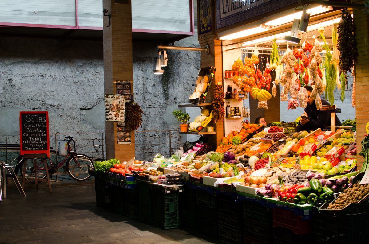
## Description Triana Market is one of the most characterful places to experience everyday Seville beyond the postcard version of the city. Set in the Triana neighborhood, it combines the energy of a traditional neighborhood market with the atmosphere of a place shaped by river life, ceramics, flamenco, and strong local identity. Visitors come here for produce, but they often stay longer because the market feels like a living introduction to the district itself. It is not a polished tourist stage. It is a working market where stallholders greet regulars, chefs shop for ingredients, and curious travelers can see how Seville still feeds itself in a very local way. What makes Triana Market especially appealing is the balance between food and history. The market sits close to the Guadalquivir River and near the area where Triana’s old artisan traditions developed, so a visit naturally turns into a wider walk through one of Seville’s most distinctive quarters. You can browse fruit, fish, meat, olives, pastries, spices, and tapas-style snacks while hearing the rhythm of a neighborhood that has long been associated with sailors, potters, and performers. A little-known detail is that the market stands near archaeological remains tied to the former Castle of San Jorge, which adds a historical layer that many visitors miss when they come only for lunch. Another less obvious fact is that the market is often the place where locals go to buy ingredients for home cooking rather than a destination designed mainly for tourists, which is part of why it feels authentic. The best experience here is not rushed. Start by looking around rather than ordering immediately, because the market rewards observation. The colors of the fruit stalls, the smell of fried food, the chatter from the bars, and the pace of local shopping all help explain why Triana is one of Seville’s most beloved neighborhoods. If you are interested in local culture, this is also an excellent point of departure for exploring ceramics shops, riverfront views, and the streets around Calle Betis and the Triana Bridge. ## Location Triana Market is in the Triana neighborhood on the west bank of the Guadalquivir River in Seville, Andalusia, Spain. The neighborhood sits just across the river from the historic center, so the market is easy to include in a day of sightseeing. If you are already in central Seville, the simplest approach is to walk across the Triana Bridge and continue into the market area on foot. That route is especially enjoyable because it gives you a clear sense of how the city changes from the monument-filled center to the more residential and traditionally working-class Triana side. If you are coming from farther away, a taxi, city bus, or a combination of walking and public transport will work well. The market is compact, so once you arrive, you will not need additional transport. It also pairs naturally with nearby river walks, ceramic workshops, and tapas stops, which makes it a practical base rather than a standalone quick stop. In hot weather, plan your arrival earlier in the day, since the surrounding streets can become warm by midday and the market itself is more enjoyable before the lunch rush. ## Tips - Go in the morning if you want the fullest market atmosphere and the best selection of produce and seafood. - Bring both cash and a card, because some smaller stalls prefer one or the other. - Do not limit yourself to shopping; the bars inside and around the market are part of the experience. - Combine the visit with a walk through Triana’s ceramic streets and the riverfront. - If you want photos, arrive early enough to avoid the busiest lunch crowd. - Ask stallholders what is in season, since that is often the fastest way to taste the most local products. ## Conclusion Triana Market is one of the most rewarding places in Seville for travelers who want local flavor, neighborhood character, and a real sense of daily life. It is easy to reach, rich in atmosphere, and memorable well beyond a simple shopping stop. ## FAQ ### Is Triana Market worth visiting even if I am not cooking? Yes. The market is worth visiting for its atmosphere, food counters, and neighborhood character even if you do not plan to buy ingredients. ### What is the best time to visit Triana Market? Morning is usually best, especially if you want fresh produce and a calmer pace before the lunch rush begins. ### Can I eat inside or near the market? Yes. The market and the surrounding streets have bars and food counters where you can eat casually and try local dishes. ### How long should I spend there? Plan at least one hour, and more if you want to combine shopping, snacks, and a walk through the neighborhood. ## Links - [Wikipedia](https://en.wikipedia.org/wiki/Triana,_Seville) - [Seville tourism information](https://www.visitasevilla.es/en)
GemVoyage Team • World

Comments