GemVoyage Team • World
Hayravank Monastery (Հայրավանք վանք) is a striking medieval complex overlooking the turquoise waters of Lake Sevan in Armenia. Modest in size yet monumental in spirit, this 9th–12th century monastery embodies the timeless harmony between Armenian architecture, nature, and spirituality.
The complex consists of a church, a chapel, and a gavit (narthex), all built from dark volcanic tuff that glows deep red and orange under the sunlight. Though simple in design, its craftsmanship reveals the hallmarks of Armenian medieval architecture: cross-domed layouts, intricately carved khachkars (stone crosses), and an unpretentious yet deeply spiritual atmosphere.
What makes Hayravank truly special is its breathtaking location—perched on a rocky cliff directly above Lake Sevan, it offers sweeping views of the surrounding mountains and shimmering water below. At sunrise or sunset, the combination of ancient stone and glowing lake light creates a scene that feels almost otherworldly.
A lesser-known fact is that local legend claims the monastery once housed a magical library of sacred scrolls, guarded by a wise monk who vanished mysteriously. Archaeologists have indeed found early manuscripts and stone inscriptions on-site, adding intrigue to this ancient story. Another fascinating aspect is that Hayravank’s design likely influenced later monasteries in the Sevan basin, helping shape Armenia’s architectural identity.
Hayravank Monastery is located in Gegharkunik Province, on the western shore of Lake Sevan in Armenia. It lies near the village of Hayravank, approximately 120 kilometers northeast of Yerevan and 20 kilometers north of Sevan town.
To get there:
Its lakeside setting makes it easy to combine a cultural visit with a picnic or a walk along the shore.
Hayravank Monastery is a masterpiece of simplicity, serenity, and natural beauty — a place where Armenia’s spiritual heritage meets the grandeur of its landscapes. With its ancient walls set against the endless blue of Lake Sevan, it stands as a quiet yet powerful reminder of the country’s medieval faith and craftsmanship. For travelers seeking peace, history, and authentic Armenian charm, Hayravank is a destination that captures the soul of the nation itself.
1. When was Hayravank Monastery built?
The main church dates to the 9th century, with additional structures, including the gavit, added in the 12th century.
2. Is the monastery still active?
It is not a full-time monastic residence but is used for religious ceremonies and services on special occasions.
3. Do I need to pay an entrance fee?
No, entrance to Hayravank Monastery is free of charge.
4. How long should I plan to stay?
Allow about 30–45 minutes to explore the complex, take photos, and enjoy the lake views.
5. Is it accessible year-round?
Yes, though winter visits can be chilly due to snow and wind. Roads are usually passable except during heavy weather.
6. Are there restaurants or facilities nearby?
There are small cafés and picnic spots near the village of Hayravank and along Lake Sevan’s western shore.
Discover more hidden gems you might love.
Minneapolis
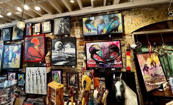
## Description Northland Visions is a well-known Native American shop in Minneapolis that celebrates Indigenous art, culture, and craftsmanship from across North America. More than just a retail space, the shop functions as a cultural bridge, offering visitors a meaningful opportunity to engage with Native traditions through authentic, ethically sourced items. The store features a wide range of products, including traditional and contemporary jewelry, beadwork, carvings, pottery, clothing, books, and ceremonial objects. What makes Northland Visions unique is its strong commitment to authenticity and Native representation. The shop works directly with Native American artists and communities, ensuring that the items sold are genuine and that artists are fairly compensated. A lesser-known fact is that Northland Visions has long been connected to the local Native community in Minnesota, particularly the Dakota and Ojibwe nations, making it an important cultural space as well as a business. Another interesting detail is that the shop often carries items connected to seasonal ceremonies and powwow culture, reflecting living traditions rather than static displays. For visitors interested in Indigenous culture, Northland Visions offers an experience rooted in respect, education, and cultural continuity. ## Location Northland Visions is located in the **United States**, in the state of **Minnesota**, within the city of **Minneapolis**. The shop is situated in the Powderhorn area of South Minneapolis, a neighborhood known for its strong community identity and cultural diversity. Visitors can reach the shop by car, public bus, or bicycle. Several Metro Transit bus routes serve the surrounding area, making it accessible from downtown Minneapolis and other neighborhoods. For those driving, street parking is generally available nearby. Using a navigation app is recommended for first-time visitors, as the shop is located in a primarily residential and commercial mixed-use area. ## Tips * Take time to ask staff about the origins and meanings of the items, as they are often happy to share cultural context. * If you are purchasing jewelry or artwork, inquire about the artist to better understand the piece’s background. * Be respectful when viewing or asking about ceremonial items, as some objects may have cultural restrictions. * Bring cash or a card, as most major payment methods are accepted. * Combine your visit with nearby local cafés or parks to explore more of South Minneapolis. * Check opening hours in advance, as they may vary seasonally or during cultural events. ## Conclusion Northland Visions offers a thoughtful and authentic introduction to Native American art and culture in Minneapolis. Through its carefully curated selection and strong community ties, the shop provides visitors with both meaningful purchases and a deeper cultural understanding. ## FAQ **Are the items at Northland Visions authentic?** Yes, the shop emphasizes genuine, Native-made products and works directly with Indigenous artists and communities. **Can I learn about the cultural significance of the items?** Yes, staff members are knowledgeable and often share information about the history and meaning behind many products. **Is Northland Visions suitable for tourists?** Absolutely. Visitors are welcome and often find the shop educational as well as culturally enriching. **Does the shop sell gifts and souvenirs?** Yes, it offers a wide range of items suitable for meaningful gifts, from small crafts to fine art pieces. **Is the shop accessible by public transportation?** Yes, multiple bus routes serve the area, making it accessible without a car. ## Links * [Northland Visions Official Website](https://www.northlandvisions.com) * [Explore Minneapolis](https://www.minneapolis.org)
GemVoyage Team • World
Stockholm
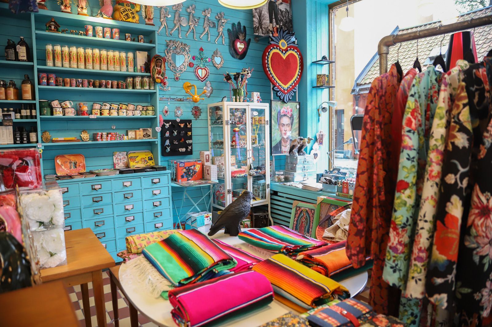
## Description Södermalm has a reputation as one of Stockholm’s most creative and self-assured districts, and its vintage shops are a big part of that identity. The area draws people who like fashion with history, pieces with character, and browsing that feels more like discovery than consumption. Unlike retail zones built around uniform shopping streets, Södermalm’s vintage scene is scattered through a district that already feels interesting to walk through. That means the shopping experience is inseparable from the neighborhood itself. The appeal of Södermalm vintage shops is not only the clothes. It is the curation, the neighborhood energy, and the sense that the area has a long memory. Stockholm’s relationship with design, sustainability, and thoughtful consumption makes secondhand shopping feel especially natural here. You can find everything from well-preserved Scandinavian basics to statement pieces, accessories, workwear, and occasional design objects. Some shops specialize tightly; others feel like treasure hunts where the best finds appear when you least expect them. One little-known fact is that Södermalm’s secondhand culture is closely tied to the district’s broader reputation for indie creativity and alternative style. Another is that many visitors underestimate how pleasant the neighborhood is for walking between shops. Even when one store is busy, the next street might feel calm, which keeps the experience relaxed and exploratory rather than transactional. For travelers who enjoy fashion but dislike generic mall shopping, this is an especially good environment. There is also a practical advantage. Vintage shopping in Södermalm can be combined with cafés, viewpoints, galleries, and neighborhood walks, so the district never feels like a single-purpose retail stop. It becomes part shopping outing, part urban exploration, and part cultural snapshot of Stockholm itself. The result is a richer visit than simply buying clothes. You are also seeing how locals shape style, reuse, and everyday city life. ## Location The vintage shops are located across Södermalm, an island district in central Stockholm, Sweden. Södermalm sits south of Gamla Stan and is one of the easiest central areas of Stockholm to explore on foot. The shopping spots are spread through several streets and pockets of the district, so the experience works best when you treat it as a neighborhood walk rather than a fixed single destination. The easiest way to reach Södermalm is by Stockholm’s metro system, bus network, or on foot from the city center. Medborgarplatsen, Slussen, and other nearby stations are practical starting points depending on which part of the district you want to explore. Because the best finds are often spread out, a comfortable pair of shoes helps more than a tightly scheduled plan. If you are visiting in winter, plan for shorter daylight hours and use indoor stops such as cafés to break up the walk. In warmer months, the district is especially pleasant because moving between shops feels almost like a mini city tour in itself. ## Tips - Start with a broad walk through the district before committing to specific shops. That helps you understand the neighborhood layout. - Look for quality as much as price. The best vintage pieces in Stockholm often stand out because of condition, cut, and timeless design. - Bring a reusable bag or extra room in your luggage if you plan to buy clothing or small home items. - Pair shopping with coffee or lunch so you can pace yourself and avoid rushed decisions. - Visit more than one shop style. A good vintage outing in Södermalm usually mixes curated boutiques, thrift stores, and neighborhood secondhand spots. ## Conclusion Södermalm’s vintage shops offer more than shopping. They give you a stylish way to experience one of Stockholm’s most characterful districts while discovering clothing and objects that feel personal, sustainable, and distinctly local. ## FAQ ### Is Södermalm good for vintage shopping even if I am not a fashion expert? Yes. The neighborhood is easy to browse casually, and many stores are approachable even if you are not hunting for something specific. The pleasure is as much in the atmosphere as in the purchase. ### Are the shops expensive? Prices vary a lot. Some stores are highly curated and price pieces accordingly, while others are more affordable. Stockholm generally has a reputation for quality over bargain-bin pricing. ### How much time should I set aside? At least a few hours if you want to enjoy the area properly. The best experience comes from mixing browsing with time for walking, coffee, and neighborhood exploration. ### Can I combine vintage shopping with other sightseeing? Definitely. Södermalm is close to scenic viewpoints, restaurants, and central Stockholm landmarks, so it fits easily into a larger city day. ## Links - [Södermalm on Wikipedia](https://en.wikipedia.org/wiki/S%C3%B6dermalm) - [Visit Stockholm](https://www.visitstockholm.com/)
GemVoyage Team • World

Oslo
## Description Vigeland Sculpture Park is already one of Oslo’s essential attractions, but its hidden corners offer a more thoughtful and rewarding experience for visitors who go beyond the main axis. Most people know the central path and the iconic sculptures that define the park’s visual identity, but the quieter side areas, peripheral routes, and less obvious viewpoints can reveal a different relationship between sculpture, space, and public life. Exploring these hidden corners gives the park a more layered feeling and helps you appreciate it as a landscape rather than just a photo stop. The obvious sculptures draw crowds for good reason, but the park’s subtler areas often show how carefully the whole environment has been designed. Small changes in angle, distance, and elevation can alter how you perceive the figures and the surrounding open space. That means a visit can become a kind of visual study if you take your time. One lesser-known fact is that the park has been shaped around a long artistic vision that extends beyond individual sculptures, which is why the less visited areas still feel coherent rather than secondary. Another interesting point is that weather and light dramatically change the experience, so even a familiar sculpture can feel new when viewed from a quiet side path. For travelers, the hidden corners are especially appealing if they want to avoid the most crowded photo spots or if they have already seen the park’s main highlights. You do not need to be an art specialist to enjoy this approach; in fact, simply slowing down and paying attention is enough. The hidden areas often reward curiosity more than prior knowledge. That makes them ideal for repeat visitors, photographers, and anyone who prefers an experience that feels slightly less scripted. ## Location Vigeland Sculpture Park is in the Frogner area of Oslo, Norway, within the larger Frogner Park. The hidden corners are scattered through the same park grounds, so they are reached by moving away from the busiest central promenade and exploring the surrounding paths. The easiest way to get there is by tram, bus, or a walk from central Oslo, followed by time on foot inside the park. Since the best hidden corners are not signposted as a separate attraction, the main strategy is to arrive at the park and then wander with intention. Comfortable walking shoes matter more than anything else. ## Tips Go early or late in the day if you want fewer crowds and more space to explore. Do not focus only on the central sculpture axis; the quieter side paths are where the hidden corners reveal themselves. Bring a camera and spend time looking back toward the main sculptures from different angles. If you have already visited once, return in another season to see how the mood changes. ## Conclusion The hidden corners of Vigeland Sculpture Park offer a richer, calmer, and more reflective way to experience one of Oslo’s signature cultural landscapes. ## FAQ ### What are the hidden corners of Vigeland Sculpture Park? They are the quieter side paths and less obvious areas beyond the park’s main sculptural route. ### Is this different from the main park visit? Yes. It is a more exploratory way to experience the same park. ### Do I need a guide to find them? No, but a slow walk and willingness to wander help a lot. ### Is it worth doing if I have already seen the park? Definitely. It gives you a deeper perspective on the layout and atmosphere. ### When is the best time to explore? Early morning, late afternoon, or any quieter period with good light. ## Links - [Official Vigeland Park information](https://vigeland.museum.no/en/vigelandpark) - [Vigeland Park on Wikipedia](https://en.wikipedia.org/wiki/Vigeland_Sculpture_Park)
GemVoyage Team • World
Lille
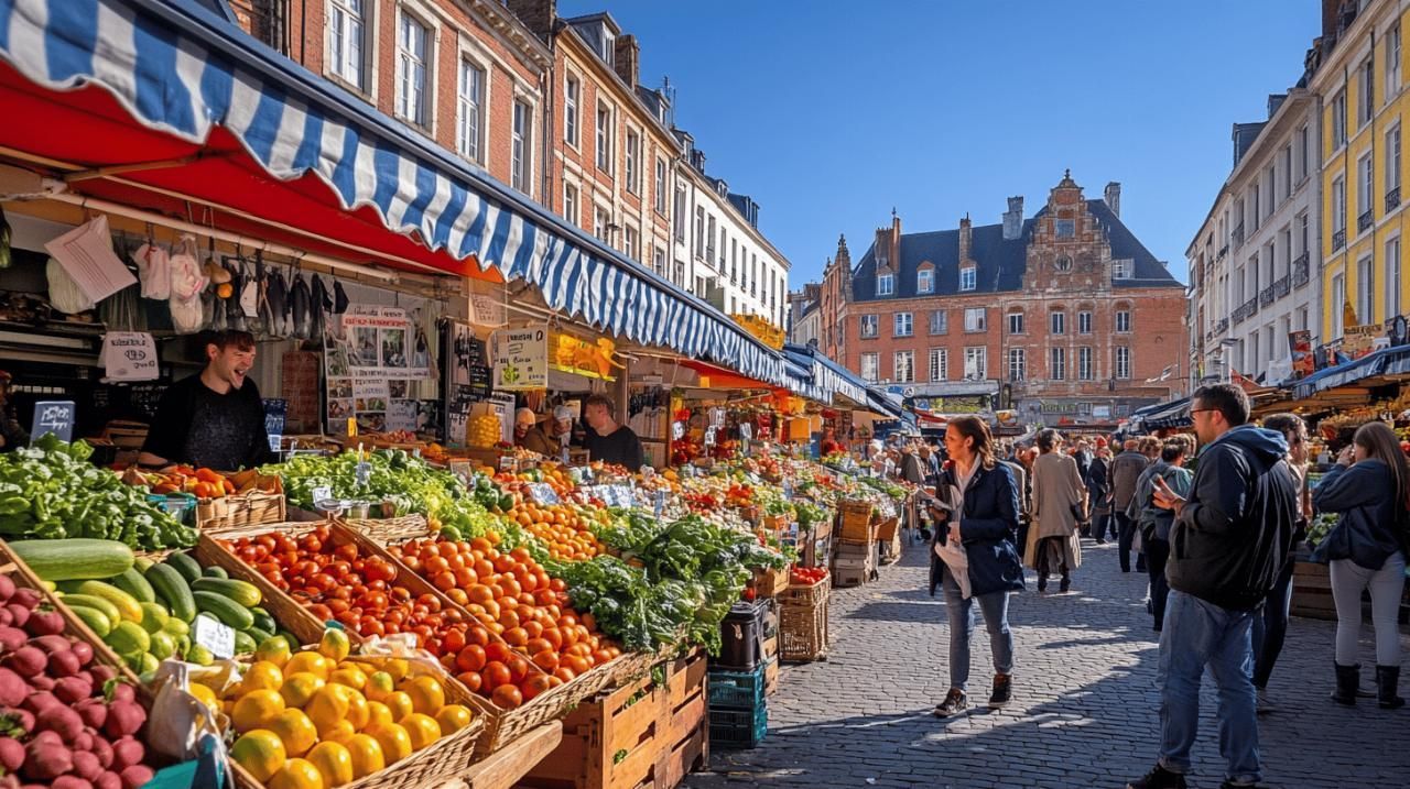
## Description Marché de Wazemmes is one of Lille’s most lively and beloved attractions, and it offers a strong sense of local character that many visitors immediately notice. The market is not polished in a museum-like way. Instead, it is bustling, practical, social, and full of everyday commerce. That is precisely why it is so appealing. If you want to understand Lille beyond its grand squares and architectural landmarks, the Wazemmes market shows how the city behaves at street level. The attraction lies in the atmosphere as much as in the products. Stalls fill the area with produce, flowers, textiles, spices, clothing, household items, and food from many different traditions. The market is animated by conversation and movement, with vendors and shoppers creating a rhythm that feels both organized and spontaneous. For visitors, it is an excellent place to observe local life while also picking up something useful or tasty. One lesser-known fact is that markets like this often reflect the cultural diversity of the neighborhood more clearly than any official sightseeing stop. Another detail many travelers enjoy is that the market changes character across the day and across the week. In the busiest periods, it can feel almost overwhelming in the best possible way, while quieter moments reveal the details of the stalls, the architecture around them, and the social habits of regular shoppers. Marché de Wazemmes is also appealing because it encourages a slower, more human style of sightseeing. You are not moving through a queue of objects behind glass. You are part of a living commercial environment where gestures, smells, colors, and sounds all matter. That makes the market especially memorable for travelers who prefer places with real local use over scripted tourist displays. The neighborhood itself adds to the visit. Wazemmes has an everyday urban energy that feels open and approachable. After the market, many visitors continue into nearby cafés or simply walk the streets to absorb the area’s personality. The market is one of those places where the surrounding context improves the experience. It tells you a lot about Lille’s identity as a northern French city with strong social and culinary traditions. ## Location Marché de Wazemmes is located in the Wazemmes district of Lille, Hauts-de-France, France, centered around the Place de la Nouvelle Aventure and the surrounding market streets. It is an easy stop if you are exploring Lille’s city center or nearby neighborhoods. The simplest way to reach it is by Lille Metro, with Wazemmes and nearby stations offering convenient access. From there, it is usually a short walk into the market area. Visitors can also arrive by bus, bike, taxi, or on foot if they are already spending time in central Lille. Since the market can become busy, public transport is often the most practical choice. ## Tips - Go early if you want the freshest produce and the easiest walking space. - Bring cash, since some vendors may prefer it over card payments. - Keep your bag secure in crowded sections. - Take your time and sample the market with all your senses, not just your eyes. - If possible, pair the visit with a café stop or a walk through the neighborhood after shopping. ## Conclusion Marché de Wazemmes is a lively, down-to-earth Lille market that gives visitors a real sense of the city’s daily rhythm and local flavor. ## FAQ ### Is Marché de Wazemmes good for tourists? Yes. It is especially good for travelers who enjoy local markets, food, and authentic neighborhood life. ### What can I expect to find there? Fresh produce, flowers, fabrics, household goods, food stalls, and many everyday products. ### Is it crowded? It can be very crowded at busy times, which is part of its appeal, but early visits are easier. ### How long should I stay? Most visitors spend 1 to 2 hours depending on whether they shop, eat, or simply browse. ### Is it easy to reach by public transport? Yes. Metro and bus access make it one of Lille’s more convenient market attractions. ## Links - [Lille tourism information](https://www.lilletourism.com/)
GemVoyage Team • World
Aswan
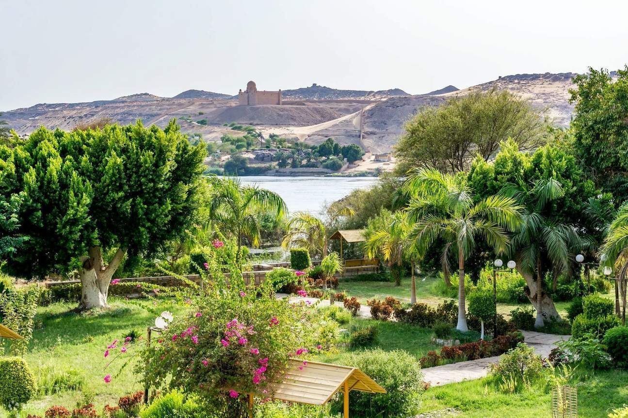
## Description The Aswan Botanical Garden is an unexpectedly verdant refuge on an island in the Nile, offering a cool, contemplative counterpoint to the monumental temples and quarries that dominate Upper Egypt’s tourism landscape. Its charm comes from a careful mix of cultivated plantings, winding pathways, and island vistas: palms, exotic trees, shaded pavilions, and thoughtfully placed seating invite visitors to slow down and enjoy the river breeze. For travelers who have spent mornings at temples and archaeological sites, the garden offers precisely the restorative pause many itineraries lack. Beyond leisure, the garden holds botanical and historical interest. Many plantings were introduced during the nineteenth and early twentieth centuries as part of botanical exchanges, and the site has long been associated with collection and study. The island location amplifies the sense of escape—the short boat journey from Aswan’s riverfront feels intentional and contributes to the visit’s narrative: you leave the bustling riverbank and step into a quieter, greener world. Birdlife, moving water, and the light across the Nile all combine to create a sensory experience that changes throughout the day. ## Location The garden is located on Kitchener’s Island (sometimes referred to historically in guidebooks), a short boat ride from Aswan’s main waterfront. Boat crossings take only a few minutes and are typically arranged through local boat operators, hotels, or Nile tour companies. Because the garden lies close to the city center, it can be combined easily with other Nile-side visits, including the Philae Temple boat ride or a felucca sail. Plan your visit for the morning or late afternoon when temperatures are milder and light is most flattering for photography. Midday in Upper Egypt can be intense, and shade is limited along some paths despite tree cover. ## Tips - Go in the cooler parts of the day—early morning or late afternoon are best for walks and photos. - Bring water, sunscreen, and a hat; shade is available but the sun can still be strong. - Arrange a reliable boat transfer—ask at your hotel or book through a reputable local operator. - Wear comfortable shoes: paths are mostly easy but can be uneven in places. - Combine the garden visit with nearby Nile-side sites to make the crossing feel part of a fuller river day. - Look for framed views through the trees toward the Nile; they make excellent photo opportunities and quiet spots to sit. ## Conclusion The Aswan Botanical Garden is a welcome respite for travelers who want a gentler pace amid an itinerary of temples and island tours. Its island setting, curated plantings, and tranquil riverside atmosphere create an appealing, low-effort stop that rewards slow exploration and quiet observation. ## FAQ ### Why visit a botanical garden in Aswan? It offers a distinctly different experience from archaeological sites: shade, plant variety, birdlife, and a slower pace that complements temple visits. ### How do I get there? Visitors reach the island by a short boat transfer from Aswan’s riverfront; boats are easy to arrange locally and typically take only a few minutes. ### Is it suitable for families? Yes. Wide paths and gentle walking conditions make the garden family-friendly, though bring water and sunscreen for young children. ### How much time should I spend there? One to two hours is usually enough for a relaxed visit; more time is pleasant for photography and lingering breaks. ### What should I bring for the visit? Comfortable shoes, water, hat, and sun protection; a camera and a small notebook are useful for nature observation. ## Links - [Wikipedia](https://en.wikipedia.org/wiki/Aswan_Botanical_Garden)
GemVoyage Team • World
Los Angeles
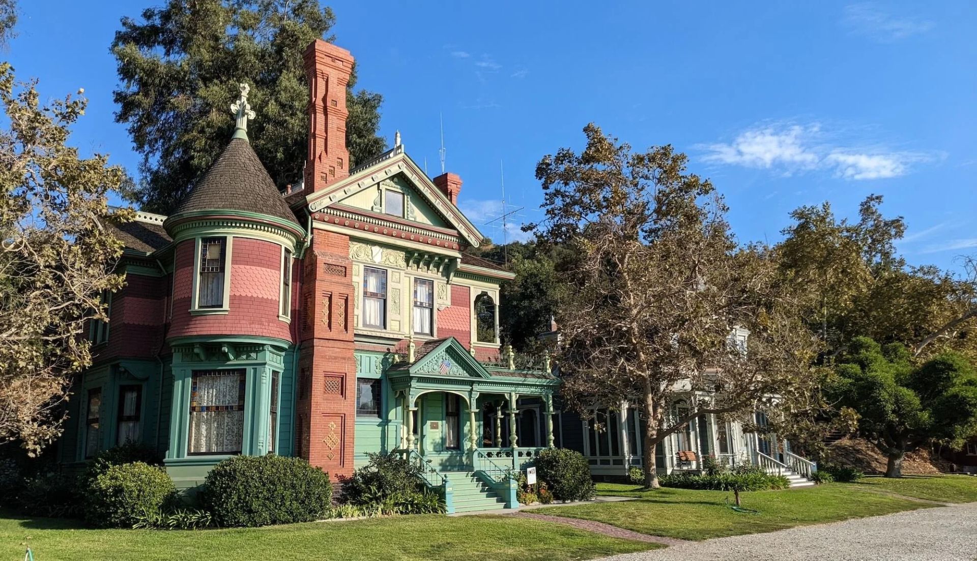
## Description Heritage Square Museum is an extraordinary open-air architectural museum that gathers Victorian and early 20th-century houses and outbuildings within a single historic district to showcase Southern California’s built environment and social history. Each structure has a carefully reconstructed exterior and interpreted interior that reveal the craftsmanship, decorative trends, and daily rhythms of life from a period when Los Angeles was transforming from a frontier town into a burgeoning metropolis. The museum stands out for the authenticity of its fabric: original trim, stained glass, tile, and millwork are preserved or painstakingly restored, and many interiors are furnished with period-appropriate objects to convey domestic stories. Preservation workshops on site keep traditional trades alive—carpentry, plasterwork, and decorative finishes are practiced as living crafts, which both supports ongoing maintenance and educates visitors about restoration techniques. Beyond architecture, Heritage Square interprets social history. Exhibits explore how families lived, worked, and entertained across different socioeconomic strata, and the museum’s programming—guided tours, living history demonstrations, and seasonal festivals—brings these narratives to life. Special events often highlight conservation issues and the ongoing need to protect historic urban fabric in the face of development pressures. For scholars, students, and casual visitors alike, the site offers layered experiences: a close reading of architectural detail, hands-on learning in workshops, and interpretive narratives that connect buildings to broader histories of migration, industry, and urban change. Its role as a rescue repository—structures moved and reassembled to avoid demolition—adds an extra dimension: many buildings carry stories of mid-century urban renewal and community efforts to preserve heritage. ## Location Heritage Square Museum is located in the Montecito Heights neighborhood of Los Angeles, California, a short drive northeast of downtown Los Angeles. The setting—on a hillside with city views—provides a scenic backdrop for exploring an era of American domestic architecture. Getting there: Driving is the most convenient option; limited on-site parking is available. Public transit can be used but often requires transfers and a short walk—check local transit schedules and plan for extra time. Rideshare and local taxis are convenient alternatives. Pair a visit with nearby cultural stops, such as the Huntington Library or local hillside parks, to create a fuller day of exploration. ## Tips - Check the museum’s tour schedule and special-event calendar before you go; guided tours offer the most context and are often led by knowledgeable docents. - Wear comfortable shoes—paths through the outdoor site can be uneven and some properties require short climbs. - Give yourself at least two hours to explore; the combination of interiors, workshops, and outdoor exhibits rewards a relaxed pace. - Bring a camera for exterior architectural photography; observe interior photography rules where posted and respect exhibit boundaries. - If interested in historic trades, inquire about workshop schedules or volunteer opportunities—many preservation skills are demonstrated on site. - Visit in spring or fall for pleasant weather and outdoor events; summer can be warm and winter may bring cooler, wetter days. ## Conclusion Heritage Square Museum preserves an essential chapter of Southern California’s architectural story. By combining rescued structures, conservation workshops, and interpretive programming, it offers a hands-on way to understand historic building crafts and the lives of the people who inhabited these homes. It is an inspiring stop for anyone interested in architecture, preservation, and urban history. ## FAQ Q: Are there guided tours? A: Yes. The museum runs scheduled guided tours and special programs; tours are recommended for first-time visitors to gain historical context and architectural insight. Q: Is the site family-friendly? A: Yes. The museum offers family-oriented programs and activities; children can learn about historic life through interactive demonstrations. Q: Can event spaces be rented? A: Select areas may be rented for private events, though availability and restrictions vary—contact the museum’s events office for details. Q: Are there volunteer opportunities or workshops? A: Yes. The museum often offers volunteer roles, preservation workshops, and demonstrations of traditional trades—check the calendar or volunteer page for current options. Q: Is the site wheelchair accessible? A: Some areas have limited accessibility due to the nature of historic structures and terrain; the museum can provide guidance on accessible routes and accommodations. Q: What’s the best way to learn about restoration techniques demonstrated on site? A: Attend preservation workshops, guided tours that focus on conservation, or scheduled demonstrations—these sessions are designed to explain both craft techniques and the rationale behind repair choices. ## Links - [Heritage Square Museum (official)](https://www.heritagesquare.org) - [Wikipedia: Heritage Square Museum](https://en.wikipedia.org/wiki/Heritage_Square_Museum)
GemVoyage Team • World


Comments