GemVoyage Team • World
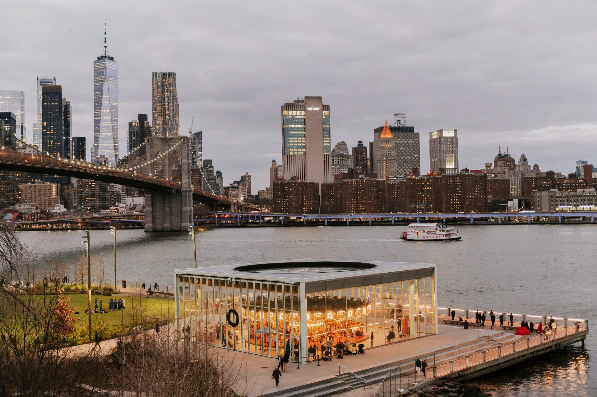
DUMBO's transformation from a gritty industrial waterfront to a creative residential and commercial neighborhood has been central to Brooklyn's broader redevelopment. The area is layered: landmark bridges and piers, converted loft buildings, independent cafes, and public spaces like Brooklyn Bridge Park all coexist in a compact grid. Many visitors first see the classic viewpoint framed by the Manhattan Bridge and then discover quieter corners—galleries, waterfront piers, and local bakeries—that reward a slower approach.
The neighborhood also plays well to varied audiences: families come for waterfront park space and playgrounds; food-focused visitors enjoy casual dining and artisanal shops; and history-minded travelers appreciate the story of urban change reflected in restored industrial buildings. These multiple attractions make DUMBO a flexible itinerary option in New York City.
Practical tips: take the F or A/C trains to nearby stops and walk, or use the NYC Ferry service for a scenic arrival. The area can be crowded at peak times, so plan early-morning or late-afternoon visits for better light and fewer people.
Discover more hidden gems you might love.
Antalya
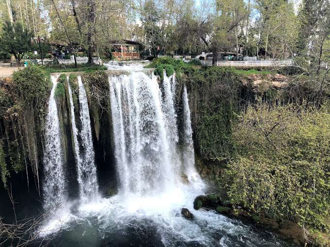
## Description Düden Waterfalls in Antalya are among Turkey’s most captivating natural attractions, offering a dramatic blend of lush greenery, cascading water, and coastal beauty. Fed by the Düden River, these waterfalls are divided into two distinct sites: the Upper Düden Waterfall (Yukarı Düden Şelalesi) and the Lower Düden Waterfall (Aşağı Düden Şelalesi). Each offers a unique experience, making them a must-visit for nature lovers, photographers, and anyone seeking a peaceful escape from the city. The Upper Düden Waterfall is nestled in a tranquil park setting, where water tumbles 20 meters into a cave-lined basin surrounded by trees and walking paths. Visitors can explore behind the waterfall through a natural cave, offering a rare perspective of the rushing water from within. The park also features picnic areas, shaded benches, and small cafés, making it ideal for a relaxed afternoon. The Lower Düden Waterfall, by contrast, is a dramatic spectacle where the river plunges 40 meters off a cliff directly into the Mediterranean Sea. Located in Düden Park in the Lara district, this waterfall is best viewed from the observation terrace or from the sea on a boat tour. The sight of the water crashing into the ocean, often accompanied by rainbows formed in the mist, is unforgettable. A little-known fact: the water that feeds the Upper Düden Waterfall originates from a karstic source and travels underground for nearly 11 miles before resurfacing. Another interesting detail is that the Lower Düden Waterfall is also known locally as Karpuzkaldıran Şelalesi, which translates to “watermelon lifter waterfall,” a name tied to local folklore. ## Location Düden Waterfalls are located in **Turkey**, in the **Antalya Province**, within the **city of Antalya**. The Upper Düden Waterfall is situated in the Kepez district, while the Lower Düden Waterfall is located in the Lara district, near the coast. ### How to Get There - **Upper Düden Waterfall**: From Antalya city center, take a taxi or drive about 10 kilometers northeast to the Kepez district. Public buses (such as bus number VC57) also serve the area. - **Lower Düden Waterfall**: Located about 8 kilometers southeast of the city center, it can be reached by taxi, car, or public buses like KL08 or LF09. Boat tours from Kaleiçi Marina also offer views from the sea. Both sites are easily accessible and can be visited in a single day. ## Tips - **Visit Both Sites**: Each waterfall offers a distinct experience—don’t miss the chance to see both. - **Bring a Camera**: The mist, cliffs, and greenery make for stunning photos, especially at sunset. - **Wear Comfortable Shoes**: Trails around the Upper Düden Waterfall can be uneven and slippery. - **Take a Boat Tour**: Viewing the Lower Düden Waterfall from the sea offers a unique and dramatic perspective. - **Pack Snacks or Picnic Supplies**: The Upper Düden site has picnic areas perfect for a leisurely meal. - **Check the Weather**: Spring and early summer offer the best conditions for photography and boat tours. ## Conclusion Düden Waterfalls are a natural gem in Antalya, offering two distinct yet equally mesmerizing experiences. Whether you’re exploring caves behind a forest waterfall or watching water plunge into the Mediterranean, this destination promises beauty, tranquility, and unforgettable views. ## FAQ **1. Is there an entrance fee to Düden Waterfalls?** Yes. The Upper Düden Waterfall charges a small entrance fee (around 70 TL), while the Lower Düden Waterfall is free to visit. **2. Can I swim near the waterfalls?** Swimming is not permitted near the waterfalls due to safety concerns, but nearby beaches offer swimming opportunities. **3. Are the waterfalls open year-round?** Yes, both sites are open throughout the year, though hours may vary seasonally. **4. Are the waterfalls suitable for children?** Yes, both locations are family-friendly, with safe paths and picnic areas. **5. How long should I plan for a visit?** Allow 1–2 hours for each site, or a half-day if visiting both. **6. Are there guided tours available?** Yes, many local tour operators offer packages that include transportation, guided visits, and boat tours. ## Links - [Official Düden Waterfalls Website](https://dudenwaterfalls.com/)
GemVoyage Team • World
.jpg)
Scotland
## Description The Fairy Pools on the Isle of Skye in Scotland are a series of crystal-clear, aqua-blue pools and cascading waterfalls that tumble down from the foothills of the Black Cuillin mountains. These natural pools, fed by the Allt Coire a’ Mhadaidh stream, are renowned for their ethereal beauty and have become one of Skye’s most iconic and photographed attractions. Whether you're a hiker, wild swimmer, or simply a lover of dramatic landscapes, the Fairy Pools offer a magical experience that feels straight out of folklore. The walk to the pools is relatively short—about 2.4 kilometers round trip—and follows a well-maintained gravel path that winds through heather-covered moorland. Along the way, visitors encounter a series of waterfalls and pools, each more striking than the last. The water is so clear that you can see the rocky bottoms and reflections of the surrounding hills, making it a favorite spot for photographers and nature enthusiasts. A little-known fact: the area around the Fairy Pools was the site of the last and bloodiest clan battle in Scottish history—the Battle of Coire na Creiche in 1601 between the MacLeods of Dunvegan and the MacDonalds of Sleat. Legend has it that the stream ran red with blood, a stark contrast to its current tranquil appearance. Another quirky detail is that despite their name, there’s no historical association with fairies—the name “Fairy Pools” only began appearing in guidebooks in the 20th century. ## Location The Fairy Pools are located in **Scotland**, on the **Isle of Skye**, near the village of **Carbost** in the **Highland region**. They sit at the base of the Black Cuillin mountains in **Glen Brittle**, on the western side of the island. ### How to Get There - **By Car**: From Portree, the island’s main town, it’s about a 30-minute drive (20.5 miles) via the B8009 and Glenbrittle road. The route includes single-track roads with passing places. - **By Bus**: Public transport is limited. Buses run to Carbost, but you’ll need to arrange a taxi or walk from there. - **By Tour**: Several guided tours from Portree or Inverness include the Fairy Pools as part of a day trip. - **By Foot**: The walk to the pools begins at the Fairy Pools car park, located near Glenbrittle. From the car park, it’s a 20-minute walk to the first waterfall. ## Tips - **Visit Early or Late**: The site gets crowded during peak hours, especially in summer. Early morning or late afternoon offers better light and fewer visitors. - **Wear Waterproof Footwear**: The path can be muddy and uneven, especially after rain. - **Bring Layers**: Weather on Skye is unpredictable. Pack a waterproof jacket and warm clothing. - **Wild Swimming**: Brave souls can swim in the pools, but the water is icy year-round. A wetsuit is recommended. - **Respect Nature**: Follow the Scottish Outdoor Access Code—take your litter with you and stick to marked paths. - **Parking**: There is a charge for parking at the Fairy Pools car park, which helps maintain the site. ## Conclusion The Fairy Pools on the Isle of Skye are a breathtaking blend of natural beauty and Highland mystique. With their vivid waters, dramatic mountain backdrop, and rich history, they offer a memorable experience for anyone exploring Scotland’s rugged landscapes. ## FAQ **1. Is there an entrance fee to visit the Fairy Pools?** No, the pools are free to visit, but there is a charge for parking. **2. How long is the walk to the Fairy Pools?** The round-trip walk is approximately 2.4 kilometers and takes 40 minutes to 1.5 hours depending on pace and stops. **3. Can I swim in the Fairy Pools?** Yes, wild swimming is allowed, but the water is extremely cold. A wetsuit is recommended. **4. Are the Fairy Pools suitable for children?** Yes, but children should be supervised due to uneven terrain and cold water. **5. Is the site wheelchair accessible?** No, the terrain is rugged and includes steep inclines, making it unsuitable for wheelchairs. **6. What is the best time of year to visit?** Spring and autumn offer mild weather and fewer crowds. Summer is busiest, while winter can be icy and less accessible. ## Links - [Fairy Pools Walk – Isle of Skye Guide](https://www.isleofskye.com/skye-guide/top-ten-skye-walks/fairy-pools) - [Fairy Pools – VisitScotland Overview](https://www.visitscotland.com/info/see-do/fairy-pools-p1770011) - [Fairy Pools – Wikipedia Entry](https://en.wikipedia.org/wiki/Fairy_Pools) Description The Fairy Pools on the Isle of Skye in Scotland are a series of crystal-clear, aqua-blue pools and cascading waterfalls that tumble down from the foothills of the Black Cuillin mountains. These natural pools, fed by the Allt Coire a’ Mhadaidh stream, are renowned for their ethereal beauty and have become one of Skye’s most iconic and photographed attractions. Whether you're a hiker, wild swimmer, or simply a lover of dramatic landscapes, the Fairy Pools offer a magical experience that feels straight out of folklore. The walk to the pools is relatively short—about 2.4 kilometers round trip—and follows a well-maintained gravel path that winds through heather-covered moorland. Along the way, visitors encounter a series of waterfalls and pools, each more striking than the last. The water is so clear that you can see the rocky bottoms and reflections of the surrounding hills, making it a favorite spot for photographers and nature enthusiasts. A little-known fact: the area around the Fairy Pools was the site of the last and bloodiest clan battle in Scottish history—the Battle of Coire na Creiche in 1601 between the MacLeods of Dunvegan and the MacDonalds of Sleat. Legend has it that the stream ran red with blood, a stark contrast to its current tranquil appearance. Another quirky detail is that despite their name, there’s no historical association with fairies—the name “Fairy Pools” only began appearing in guidebooks in the 20th century. Location The Fairy Pools are located in Scotland, on the Isle of Skye, near the village of Carbost in the Highland region. They sit at the base of the Black Cuillin mountains in Glen Brittle, on the western side of the island. How to Get There By Car: From Portree, the island’s main town, it’s about a 30-minute drive (20.5 miles) via the B8009 and Glenbrittle road. The route includes single-track roads with passing places. By Bus: Public transport is limited. Buses run to Carbost, but you’ll need to arrange a taxi or walk from there. By Tour: Several guided tours from Portree or Inverness include the Fairy Pools as part of a day trip. By Foot: The walk to the pools begins at the Fairy Pools car park, located near Glenbrittle. From the car park, it’s a 20-minute walk to the first waterfall. Tips Visit Early or Late: The site gets crowded during peak hours, especially in summer. Early morning or late afternoon offers better light and fewer visitors. Wear Waterproof Footwear: The path can be muddy and uneven, especially after rain. Bring Layers: Weather on Skye is unpredictable. Pack a waterproof jacket and warm clothing. Wild Swimming: Brave souls can swim in the pools, but the water is icy year-round. A wetsuit is recommended. Respect Nature: Follow the Scottish Outdoor Access Code—take your litter with you and stick to marked paths. Parking: There is a charge for parking at the Fairy Pools car park, which helps maintain the site. Conclusion The Fairy Pools on the Isle of Skye are a breathtaking blend of natural beauty and Highland mystique. With their vivid waters, dramatic mountain backdrop, and rich history, they offer a memorable experience for anyone exploring Scotland’s rugged landscapes. FAQ 1. Is there an entrance fee to visit the Fairy Pools? No, the pools are free to visit, but there is a charge for parking. 2. How long is the walk to the Fairy Pools? The round-trip walk is approximately 2.4 kilometers and takes 40 minutes to 1.5 hours depending on pace and stops. 3. Can I swim in the Fairy Pools? Yes, wild swimming is allowed, but the water is extremely cold. A wetsuit is recommended. 4. Are the Fairy Pools suitable for children? Yes, but children should be supervised due to uneven terrain and cold water. 5. Is the site wheelchair accessible? No, the terrain is rugged and includes steep inclines, making it unsuitable for wheelchairs. 6. What is the best time of year to visit? Spring and autumn offer mild weather and fewer crowds. Summer is busiest, while winter can be icy and less accessible. Links Fairy Pools Walk – Isle of Skye Guide Fairy Pools – VisitScotland Overview Fairy Pools – Wikipedia Entry 715 words37 lines4484 characters4520 bytes
GemVoyage Team • World
Berlin
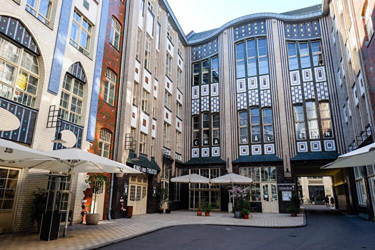
## Description **Hackesche Höfe** is one of Berlin’s most distinctive architectural and cultural complexes, known for its **series of interconnected courtyards**, richly decorated façades, and lively mix of art, retail, and everyday urban activity. Completed in **1906**, the complex was designed by architect **August Endell** and is considered one of the most important examples of **Jugendstil (Art Nouveau)** architecture in Germany. What makes Hackesche Höfe unique is its structure: eight separate courtyards connected by narrow passageways, forming a small urban world within the city. Originally, the complex combined residential apartments, workshops, offices, and entertainment venues, reflecting early 20th-century ideas about efficient mixed-use development. This design allowed craftsmen, artists, and residents to live and work in close proximity, a concept that feels surprisingly modern today. A lesser-known fact is that Hackesche Höfe narrowly escaped demolition during the post-war period, when much of the surrounding area was heavily damaged and later neglected. During the division of Berlin, the complex fell into disrepair, especially in the eastern sector. Its careful restoration in the 1990s played a key role in the **revitalization of Mitte**, helping transform the district into one of Berlin’s cultural and creative centers. Today, Hackesche Höfe hosts boutiques, design shops, cafés, galleries, cinemas, theaters, and apartments. The atmosphere shifts throughout the day, from quiet mornings to lively evenings, making it a place that rewards repeat visits. Despite its popularity, the courtyards retain a sense of intimacy that contrasts with the busy streets just outside. ## Location **Country:** Germany **Region:** Berlin **City:** Berlin **District:** Mitte Hackesche Höfe is located just off **Rosenthaler Straße**, close to Alexanderplatz and the Hackescher Markt area. ### How to Get There * **By S-Bahn:** * Take any line to **Hackescher Markt** station. From there, it is a 5-minute walk. * **By tram:** * Several tram lines stop at Hackescher Markt, offering easy access from across the city. * **By U-Bahn:** * Line U8 to **Weinmeisterstraße**, followed by a short walk. * **On foot:** * Easily reachable from Museum Island and Alexanderplatz. ## Tips * **Explore all courtyards:** Many visitors stop at the first courtyard, but the quieter inner ones are worth seeking out. * **Visit during the day for architecture:** Jugendstil details are best appreciated in natural light. * **Return in the evening for dining and culture:** Restaurants, theaters, and the cinema create a vibrant nightlife atmosphere. * **Be mindful of residential areas:** Some courtyards still contain private apartments. * **Combine with nearby attractions:** Museum Island, Monbijou Park, and the Jewish Quarter are close by. * **Photography is allowed:** Just avoid disturbing patrons or residents. ## Conclusion Hackesche Höfe is a living example of Berlin’s layered history, combining early modern architecture with contemporary creative life. Its courtyards offer a unique way to experience the city’s past and present in a single, walkable space, making it an essential stop for visitors to Berlin. ## FAQ **1. What does Hackesche Höfe mean?** It translates roughly to “Hackesche Courtyards,” referring to the interconnected inner yards. **2. Is there an entrance fee?** No. The courtyards are freely accessible. **3. How long should I plan for a visit?** About **1–2 hours**, depending on shopping, dining, or cultural activities. **4. Are guided tours available?** Occasionally, through private tour operators focusing on Berlin architecture or history. **5. Is Hackesche Höfe suitable for families?** Yes, though it is more oriented toward adults and cultural exploration. **6. What is the best time to visit?** Late afternoon to evening offers a balance of light, atmosphere, and open venues. ## Links * [Berlin tourism official site](https://www.visitberlin.de)
GemVoyage Team • World
Cairo
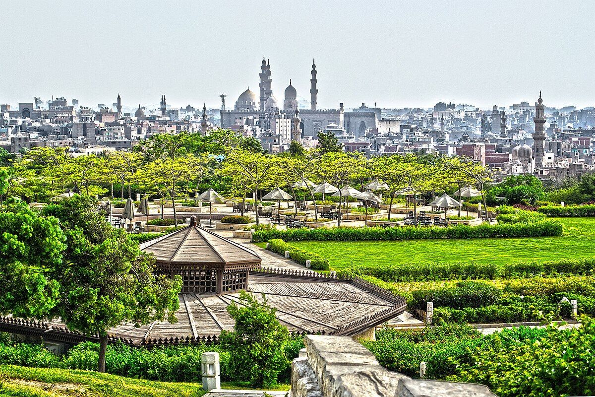
## Description Al-Azhar Park is one of Cairo’s most rewarding urban escapes, and it stands out because it is much more than a public garden. It is a carefully designed landscape set high above one of the oldest parts of the city, where visitors can look out over domes, minarets, and tightly woven streets that have defined Cairo for centuries. The contrast is what makes the park memorable: inside the gates, the noise of the city softens, the paths open up, and the view becomes the main attraction. From almost any elevated point in the park, Old Cairo looks like a living museum, with the Citadel, historic mosques, and dense neighborhoods stretching into the distance. What many visitors do not realize is that the park was created on land that had long been used as a dumping ground. The transformation was not cosmetic. It involved an ambitious restoration effort that turned a neglected hill into a civic landscape with gardens, water features, shaded walks, and family-friendly gathering spaces. That history adds an important layer to the visit, because it makes the park feel like a symbol of renewal rather than just a scenic stop. Another little-known detail is that the site was opened after years of landscaping work meant to reclaim the land while respecting the visual character of Cairo’s historic skyline. The park also has a strong social and cultural dimension. It is a place where local families come for afternoon walks, photographers come for golden-hour views, and travelers come to catch their breath between the intensity of Cairo’s monuments and traffic. Restaurants and cafés inside the park make it possible to spend several hours there without feeling rushed. That is one reason Al-Azhar Park works so well as a travel attraction: it gives you a calmer, more reflective way to experience the city, while still keeping you close to the stories that made Cairo famous. The best way to appreciate the park is to slow down. A quick visit will give you the view, but a longer stay lets you notice the layout, the planting, and the way the park frames the surrounding architecture. At different times of day, the mood changes dramatically. Morning is quieter and better for walking, while late afternoon is ideal for photos. After sunset, the historic city lights begin to glow and the park takes on a softer, more romantic atmosphere. ## Location Al-Azhar Park is in Cairo, Egypt, on elevated ground near the historic core of the city. It is especially close to Islamic Cairo and sits within easy reach of major landmarks such as the Citadel and Khan el-Khalili. Because it is positioned above the old city, part of the experience is the panoramic outlook rather than a single building or monument. If you are coming from central Cairo, the most practical approach is to take a taxi or ride-hailing car directly to the park entrance. That is the simplest option for first-time visitors because it avoids the stress of navigating dense traffic and narrow streets on your own. Travelers staying near Downtown Cairo or in the historic district can also combine the park with nearby sightseeing on the same day. For those who prefer to explore by taxi, ask the driver to take you to Al-Azhar Park and confirm the entrance before arriving, since local access points can be confusing in the surrounding neighborhood. The park is well placed for a broader Cairo itinerary. You can pair it with a visit to nearby mosques, the old market area, or the Citadel, then finish the day with a meal overlooking the city. That makes it one of the easiest attractions to build into a full sightseeing route without wasting time in transit. ## Tips Visit later in the day if possible, because the light is better and the city view becomes more striking as the sun drops. If you want photos, bring a camera or phone with a wide-angle lens setting, since the skyline is one of the main reasons to come. Wear comfortable shoes. The park is easy to walk, but it covers more ground than many first-time visitors expect, and some viewpoints are best reached on foot rather than by trying to shortcut the layout. A light layer is also useful in cooler months or on windy evenings, especially if you plan to stay until after sunset. Do not treat the park as only a quick stop. Budget enough time for a relaxed walk, a pause at a café, and a slow look at the surrounding historic district. If you are visiting Cairo in the heat, the shaded areas and the open space can make the park feel like a practical break from the city’s intensity. If you are traveling with family, this is one of the easier places in Cairo to spend a calm few hours. It is also a strong option if you want a view-driven attraction that still feels rooted in local life rather than purely touristic. ## Conclusion Al-Azhar Park is one of Cairo’s most distinctive attractions because it combines landscape design, history, and panoramic city views in a single visit. It is both a peaceful retreat and a memorable way to understand the scale and beauty of historic Cairo. ## FAQ **Is Al-Azhar Park worth visiting?** Yes. It offers some of the best views in Cairo, a pleasant walking experience, and a chance to see the city from a calmer perspective. **How much time do I need there?** Most visitors should plan for at least one to two hours, and longer if they want to eat, relax, or take photos at different viewpoints. **Can I visit in the evening?** Yes. Late afternoon and early evening are often the best times for both comfort and photography. **Is it family-friendly?** Very much so. It is one of Cairo’s more comfortable outdoor spaces for families and casual visitors. **What should I combine it with nearby?** The Citadel, Khan el-Khalili, and other Islamic Cairo landmarks fit naturally into the same day. ## Links - [Wikipedia](https://en.wikipedia.org/wiki/Al-Azhar_Park)
GemVoyage Team • World
Milan
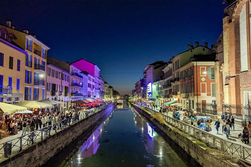
## Description The Navigli District is one of Milan’s most recognizable and enjoyable neighborhoods, especially for travelers who want atmosphere rather than a single monument. Centered on the city’s canal system, the area blends waterfront walks, small bridges, restaurants, bars, antique shops, and evening energy into a district that feels both historic and social. It is one of the best places in Milan to slow down and experience the city as a place of daily life, design, food, and nightlife rather than only fashion and business. What makes Navigli particularly interesting is the way its waterways connect modern leisure with older transport history. The canals were once part of a much more important urban system used for movement and trade, and the district still carries traces of that older role even though its present identity is more about strolling, aperitivo, and weekend crowds. A little-known fact is that the Navigli network is associated with the broader historical engineering culture of Milan, including work connected to Leonardo da Vinci’s canal and lock studies. Another detail many visitors do not realize at first is that the district changes character dramatically between day and night: daytime can feel relaxed and photogenic, while evenings often become busy, social, and lively. The Navigli District is also one of the city’s best places for aperitivo culture, where a drink often comes with snacks and the social ritual becomes as important as the menu. That makes the district especially appealing to travelers who want to understand Milan through its rhythms rather than through a checklist of attractions. The canals create the setting, but the real experience comes from the combination of reflection on the water, people watching, informal dining, and easy movement between small venues. If you are looking for a neighborhood that feels memorable without demanding a strict itinerary, Navigli is one of Milan’s strongest choices. ## Location The Navigli District is in southwestern central Milan, Lombardy, Italy, around the Naviglio Grande and Naviglio Pavese canal areas. It is easy to reach from the center of the city by metro, tram, or taxi, and many visitors walk there from nearby neighborhoods when the weather is pleasant. Porta Genova is one of the most convenient transit points for reaching the district, and from there it is simple to continue on foot toward the canal banks. Because the district is compact and best enjoyed at a relaxed pace, walking is the ideal way to experience it once you arrive. You can follow the canal, stop for a drink or meal, browse side streets, and continue without needing a fixed plan. If you visit on a Sunday or during a special market day, expect the area to be busier than usual, but also more lively. For travelers staying in central Milan, it is an easy half-day or evening destination and one of the most rewarding neighborhoods to revisit more than once. ## Tips - Go at sunset or early evening if you want the most atmospheric canal views. - Reserve enough time for aperitivo, because it is part of the Navigli experience. - Visit on a Sunday if you want markets and a more traditional neighborhood feel. - Wear comfortable shoes and be ready to walk between bridges and side streets. - If crowds are not your style, explore earlier in the day before the nightlife crowd arrives. - Combine the district with a relaxed meal rather than treating it like a quick photo stop. ## Conclusion The Navigli District is one of Milan’s most appealing neighborhoods because it mixes water, history, food, and social life in a way that feels naturally urban. It is a place to wander, eat, and enjoy the city at a slower pace. ## FAQ ### What is the Navigli District known for? It is known for its canals, aperitivo culture, lively restaurants, and atmospheric evening walks. ### Is Navigli good for a night out? Yes. It is one of Milan’s most popular areas for dinner, drinks, and evening socializing. ### Can I visit during the day? Absolutely. Daytime is often better for quiet walks, photos, and shopping. ### How much time should I spend there? At least two to three hours is a good starting point, though many visitors stay longer. ## Links - [Official Milan tourism page](https://www.yesmilano.it/en) - [Milan city information](https://www.comune.milano.it/)
GemVoyage Team • World
Milan
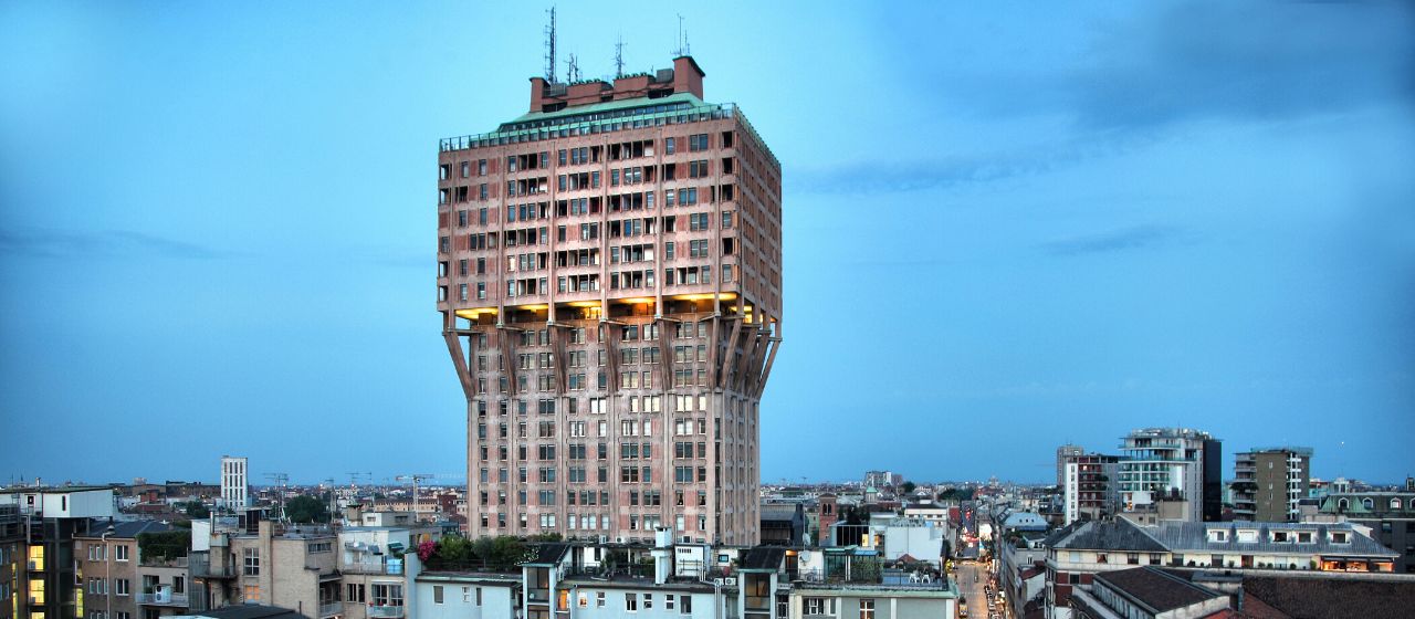
## Description The **Torre Velasca** is one of Milan’s most recognizable—and most controversial—architectural landmarks. Rising sharply above the historic city center, this distinctive skyscraper challenges the visual harmony of Milan with a form that defies both traditional elegance and modernist simplicity. Completed in **1958**, Torre Velasca represents a bold experiment in **post-war Italian architecture**, blending **medieval visual references with modern structural engineering**. Designed by the prestigious **BBPR architectural collective** (Banfi, Belgiojoso, Peressutti, and Rogers), the tower was conceived during a period when Italy was rebuilding not only its cities, but its cultural identity after World War II. Rather than copying American glass skyscrapers, BBPR attempted to create a **uniquely Italian vertical building**, rooted in Milan’s historical skyline of towers, fortifications, and cathedrals. The most striking feature of Torre Velasca is its **mushroom-shaped profile**. The lower portion is slim and vertical, while the upper floors expand outward dramatically, creating the impression of a fortress suspended in midair. This unusual silhouette deliberately echoes the **medieval defensive towers** that once protected Italian cities. The exterior façade, with its exposed concrete ribs and reddish-brown cladding, reinforces the impression of strength and permanence rather than lightness or transparency. Functionally, the tower was built as a **mixed-use structure**, combining offices in the lower levels and residential apartments in the expanded upper portion. This dual function was innovative for its time and contributed to the tower’s distinctive form—wider upper floors were better suited for domestic layouts with larger windows and more light. Artistically, Torre Velasca sits in a unique position between **Brutalism, Rationalism, and Neo-Medievalism**. Some critics consider it awkward or aggressive, arguing that it clashes with Milan’s Renaissance and Gothic heritage. Others see it as a courageous refusal to submit to anonymous international modernism. Over time, what was once widely criticized has become a **symbol of intellectual resistance in architecture**, representing Milan’s willingness to experiment rather than imitate. A little-known fact is that one of the architects, **Gian Luigi Banfi**, died in a Nazi concentration camp during World War II, and the tower stands partly as a symbolic continuation of the group’s interrupted pre-war ambitions. Another lesser-known detail is that construction techniques used in Torre Velasca directly influenced **later Italian concrete tower projects** in the 1960s and 1970s, making it a reference point for generations of architects. Today, Torre Velasca remains fully functional and continues to divide opinion. To some, it is Milan’s “ugliest skyscraper.” To others, it is one of its most intellectually daring. What is beyond dispute is that the tower is an **unavoidable visual statement**, standing as a reminder that urban identity can be built not only on beauty, but also on creative risk. ## Location **Torre Velasca** is located in the **historic center of Milan**, just a short walk from several of the city’s most important landmarks. **City:** Milan **Region:** Lombardy (Lombardia) **Country:** Italy **District:** Centro Storico ### How to Get There: * **By metro:** * **Line M3 (Yellow Line)** to **Missori Station**, then walk 5 minutes. * **Line M1 (Red Line)** to **Duomo Station**, then walk about 10 minutes. * **By tram:** Multiple central tram lines stop near the tower. * **By foot:** Easily reachable from **Milan Cathedral (Duomo)**, the **University of Milan**, and **San Bernardino alle Ossa**. * **By taxi or ride-hailing apps:** Direct access is easy from anywhere in the city center. Its central location allows visitors to integrate Torre Velasca into almost any walking itinerary of historic Milan. ## Tips * **Best viewed from multiple distances:** The unusual shape is most striking when seen from both nearby streets and distant viewpoints. * **Combine with Duomo and University of Milan:** All are within easy walking distance. * **Do not expect interior tourism access:** The tower is primarily a **private residential and office building**. * **Photography works best at sunset:** Warm light highlights the tower’s textured concrete façade. * **Architecture-first attraction:** This site is most rewarding for visitors interested in **urban design and modern architecture**, not traditional sightseeing. * **Look for contrast:** Observe how the tower interacts visually with Gothic spires and Renaissance façades nearby. * **Read about its history before visiting:** Understanding its post-war context significantly enhances appreciation. ## Conclusion The **Torre Velasca** is not designed to impress everyone—and that is precisely its strength. As a bold post-war experiment, it challenges conventional ideas of beauty, heritage, and modernity within one of Europe’s most historically refined cities. Whether admired or criticized, the tower remains a defining symbol of Milan’s **architectural independence and intellectual courage**, proving that controversy can be as enduring as elegance. ## FAQ **1. Why is Torre Velasca so controversial?** Because its **fortress-like modern design sharply contrasts** with Milan’s classical skyline, dividing public opinion. **2. Can visitors go inside Torre Velasca?** No. It is mainly a **private residential and office building** and is not generally open to tourists. **3. Who designed Torre Velasca?** It was designed by the **BBPR architectural group**, one of Italy’s most influential post-war design collectives. **4. What architectural style does it represent?** It blends **Brutalism, Rationalism, and Neo-Medieval influences**, making it difficult to classify under a single style. **5. How tall is Torre Velasca?** It stands approximately **106 meters (348 feet)** tall. **6. Is Torre Velasca considered a protected building?** Yes. It is now recognized as an **important monument of 20th-century Italian architecture**. ## Links * [Wikipedia Page](https://en.wikipedia.org/wiki/Torre_Velasca)
GemVoyage Team • World

Comments