GemVoyage Team • World
Caretta Shiodome (カレッタ汐留) is a striking skyscraper complex in the Shiodome district of Tokyo, Japan, that perfectly embodies the city’s modern sophistication and cultural vibrancy. Rising 51 stories above the bustling streets of Minato Ward, this landmark blends shopping, dining, art, and entertainment into one of Tokyo’s most polished urban experiences.
Opened in 2002, Caretta Shiodome is part of the Shiodome redevelopment project that transformed an old railway yard into a futuristic business and leisure zone. Inside, visitors will find an elegant mix of restaurants, boutique shops, a theater, a museum, and panoramic observation areas — all designed with contemporary style and efficiency.
What makes Caretta Shiodome truly unique is its seamless combination of commerce and culture. It houses the Caretta Shiodome Sky View, an observation area on the 46th floor offering spectacular views of Tokyo Bay, Odaiba, and the Rainbow Bridge. The complex is also home to the Advertising Museum Tokyo (ADMT), Japan’s only museum dedicated to the history of advertising — a fascinating and often overlooked gem that reveals how Japanese media and design evolved over the decades.
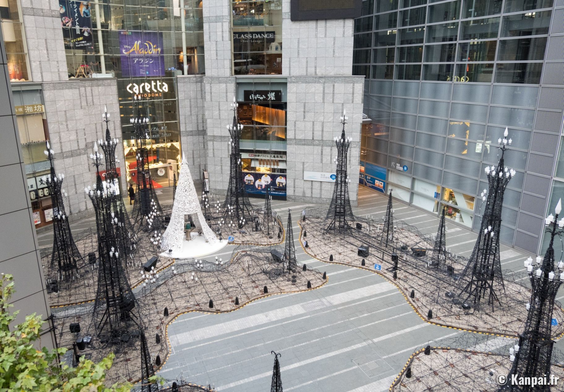
Another standout feature is the Caretta Illumination, one of Tokyo’s most beloved winter light displays. Each year, from November through February, the plaza outside the building is transformed into a glittering wonderland of over 250,000 LED lights, synchronized to music. It attracts couples, photographers, and families alike, and has become a symbol of Tokyo’s festive season.
A lesser-known fact is that Caretta Shiodome’s name, “Caretta,” is derived from Caretta caretta, the Latin name for the loggerhead sea turtle, symbolizing endurance, longevity, and connection to the ocean — an apt metaphor for Tokyo’s harmony between progress and nature.
Caretta Shiodome is located in the Shiodome district of Minato Ward, Tokyo, Japan. It sits within the Shiodome City Center area, just a short walk from Shimbashi Station and surrounded by major landmarks like the Hamarikyu Gardens and Ginza.
To get there:
* Take the Toei Ōedo Line or Yurikamome Line to Shiodome Station (direct underground access).
* Alternatively, take the JR Yamanote Line or Tokyo Metro Ginza Line to Shimbashi Station, and walk about 5 minutes via underground passages.
Caretta Shiodome is a shining example of modern Tokyo — a place where art, architecture, and lifestyle converge high above the city streets. From its world-class restaurants and free observation decks to its mesmerizing light displays and creative museum, it offers something for everyone. Whether you’re looking to dine with a skyline view, learn about Japan’s advertising culture, or simply soak in the illuminated atmosphere of Tokyo at night, Caretta Shiodome delivers a distinctly urban yet deeply memorable experience.
1. What is Caretta Shiodome?
It’s a high-rise complex in Tokyo that features shopping, dining, a theater, the Advertising Museum Tokyo, and seasonal events like the Caretta Illumination.
2. Where is it located?
At 1-8-2 Higashi-Shimbashi, Minato-ku, Tokyo, within walking distance from Shiodome Station and Shimbashi Station.
3. Is there an observation deck?
Yes — the Sky View on the 46th and 47th floors offers free access to stunning views of Tokyo Bay and the skyline.
4. What is the Caretta Illumination?
A famous winter light display that transforms the plaza into a sea of LED lights, usually from November to February each year.
5. Is the Advertising Museum Tokyo free?
Yes, entry is free, and it’s a must-visit for those interested in Japanese advertising, pop culture, and design history.
6. Are there restaurants with views?
Yes, several high-end restaurants and bars offer panoramic dining experiences overlooking Tokyo Bay and the Shiodome area.
Discover more hidden gems you might love.
Paris
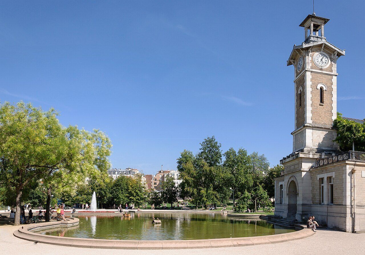
## Description **Parc Georges-Brassens** is a spacious and character-rich public park located in the 15th arrondissement of Paris. Unlike the city’s grand formal gardens, this park stands out for its **layered history and community-oriented atmosphere**. Opened in 1980, it occupies the former site of the **Vaugirard slaughterhouses**, once a major hub of Paris’s meat trade. Rather than erasing this past, the park subtly integrates it into its design, creating a space where history, greenery, and everyday Parisian life intersect. The park is named after **Georges Brassens**, one of France’s most beloved singer-songwriters, who lived nearby for many years. References to his work and personality appear discreetly throughout the park, reinforcing its cultural identity without turning it into a monument. The layout blends wide lawns, rose gardens, vineyards, and quiet corners with views over the surrounding neighborhood. One of the park’s most distinctive features is its **working vineyard**, a rare sight in modern Paris. Each year, a small grape harvest takes place, continuing a tradition that once characterized this area before industrial development. Another lesser-known element is the presence of restored wine presses and livestock market structures, which hint at the site’s former commercial function and give the park a slightly industrial undertone beneath its greenery. Parc Georges-Brassens is especially appreciated by locals. It attracts families, readers, joggers, and retirees rather than large tourist crowds. This gives the park a relaxed and authentic rhythm, offering visitors a chance to experience Paris as residents do rather than through postcard landmarks. ## Location **Country:** France **Region:** Île-de-France **City:** Paris **Arrondissement:** 15th arrondissement The park is located in southwestern Paris, surrounded by residential streets and local markets, far from the city’s main tourist corridors. ### How to Get There * **By metro:** * Take Line 12 to **Convention** station or Line 13 to **Porte de Vanves**, followed by a short walk. * **By bus:** * Several bus lines stop near the park, making access easy from different parts of Paris. * **By bicycle:** * The surrounding streets are bike-friendly, and bike racks are available near entrances. * **On foot:** * Easily reachable from nearby neighborhoods in the 15th arrondissement. ## Tips * **Visit on weekends for the book market:** A well-known second-hand book market takes place nearby, especially on Saturdays and Sundays. * **Explore the vineyard area:** It’s small but unusual and worth seeking out. * **Bring a book or picnic:** The park has plenty of benches and grassy areas suitable for relaxing. * **Come in spring or early summer:** The rose gardens and flowering areas are at their best. * **Observe local life:** This is a neighborhood park, ideal for people-watching rather than sightseeing. * **Dogs are allowed in designated areas:** Check signage to avoid restricted zones. ## Conclusion Parc Georges-Brassens offers a quieter, more personal side of Paris. With its vineyard, literary connections, and layered industrial history, it provides a refreshing alternative to the city’s iconic gardens and a genuine glimpse into everyday Parisian leisure. ## FAQ **1. Who was Georges Brassens?** He was a famous French singer-songwriter and poet who lived nearby and became one of France’s most influential cultural figures. **2. Is Parc Georges-Brassens free to enter?** Yes, the park is open to the public and free of charge. **3. How much time should I plan for a visit?** About **1 to 2 hours**, longer if you plan to relax or picnic. **4. Is the park suitable for children?** Yes. It has open lawns, play areas, and a calm environment for families. **5. Can tourists enjoy this park?** Absolutely, especially those interested in local neighborhoods rather than major attractions. **6. Are there cafés inside the park?** No permanent cafés inside, but many local cafés and bakeries are located nearby. ## Links * [City of Paris](https://www.paris.fr)
GemVoyage Team • World
Juodkrantė
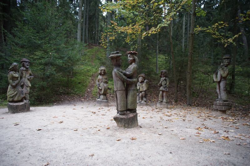
## Description The Hill of Witches (Raganų Kalnas) near Juodkrantė is an outdoor open-air gallery where folklore and forest meet. Carved wooden sculptures—dozens of them—depict figures from Lithuanian myths, pagan legends, and fairytales, arranged along a winding forest path that rises toward the Dune Rim. This combination of art and natural setting creates a narrative walk: each sculpture is a tableau within the pine woods, offering an immersive way to learn about Baltic mythology while enjoying the seaside atmosphere of the Curonian Spit. Little-known facts: many sculptures are replaced or restored periodically because of the coastal weather; the site has also hosted temporary contemporary art installations connecting modern voices to age-old tales. Additionally, the hill was intentionally designed to blend with the natural dune and forest so that the art feels like an organic part of the landscape rather than an imposition. The site is both poetic and family-friendly, with hauntingly beautiful carvings that are approachable for children while thought-provoking for adults. Seasonal cultural events sometimes include storytelling evenings and folklore workshops. ## Location Raganų Kalnas is on the Curonian Spit, an elongated sand dune peninsula that separates the Curonian Lagoon from the Baltic Sea, in western Lithuania. The hill lies near the small resort village of Juodkrantė in Neringa municipality, Klaipėda County. How to get there: Neringa is reachable by ferry or car via Klaipėda and then over the Curonian Spit road; public buses connect Klaipėda with Nida and other Spit settlements. From Juodkrantė center, the Hill of Witches is an easy walk along marked paths. ## Tips - Visit early morning or late afternoon to avoid crowds and capture the soft light through the pines. - Wear sturdy shoes—the path can be sandy and uneven. - Bring a guidebook or download a map to understand the individual sculptures and stories. - Check for temporary exhibitions or cultural events—these often enhance the experience. - Combine the visit with a walk along the nearby dunes or a ferry ride on the Curonian Lagoon. ## Conclusion The Hill of Witches is a uniquely Baltic blend of art, folklore, and landscape: a short visit on the Curonian Spit that leaves a lasting impression through its carved narratives and coastal forest atmosphere. ## FAQ Q: Is the Hill of Witches accessible year-round? A: Yes, but winter weather can be harsh; spring through autumn is optimal. Q: Are the sculptures original? A: Many are original but are periodically replaced or restored due to weathering. Q: Is there an entrance fee? A: There may be a modest fee for some event programs, but the site is generally free to visit. Q: Can I bring children? A: Yes—children usually enjoy the sculptural storytelling. ## Links - [Hill of Witches (Wikipedia)](https://en.wikipedia.org/wiki/Hill_of_Witches)
GemVoyage Team • World
Paris
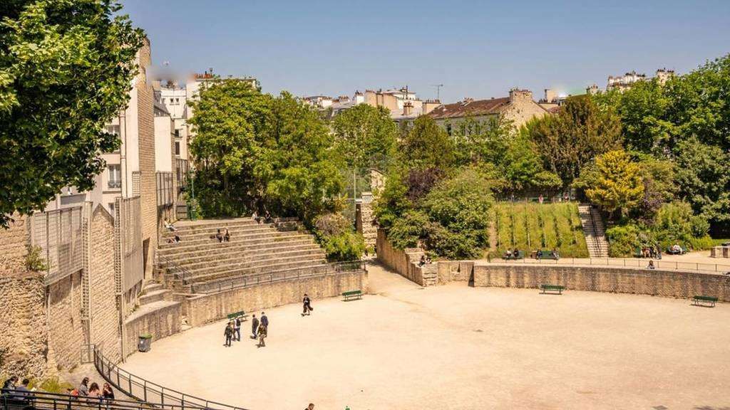
## Description **Arènes de Lutèce** is one of Paris’s most unexpected and historically significant sites: a **Roman amphitheater hidden in plain sight** within the Latin Quarter. Dating back to the **1st century CE**, it is among the oldest surviving monuments in the city and a rare physical reminder of Lutetia, the Gallo-Roman settlement that preceded modern Paris. Unlike the grand, fully preserved amphitheaters of southern France or Italy, the Arènes de Lutèce is fragmentary, modest in scale, and deeply embedded in its urban surroundings. This is precisely what makes it compelling. The remains include portions of the arena floor, tiered seating, subterranean chambers, and traces of the stage wall. In its prime, the amphitheater could accommodate **up to 15,000 spectators**, hosting gladiatorial combats, animal hunts, and theatrical performances. What sets the Arènes de Lutèce apart is its **history of disappearance and rediscovery**. After the fall of the Roman Empire, the structure was gradually dismantled and buried beneath medieval buildings. By the Middle Ages, its existence was largely forgotten. It was not rediscovered until the 19th century during urban works, and even then, much of it was threatened by redevelopment. The site was ultimately saved following public campaigns supported by prominent cultural figures, including Victor Hugo. A lesser-known fact is that the amphitheater served multiple secondary purposes over time. During the Middle Ages, stones from the structure were reused in nearby buildings, effectively dissolving it into the fabric of the city. Another overlooked detail is that today’s visible remains represent **only a fraction** of the original structure; much of it still lies beneath surrounding streets and buildings, preserved underground rather than reconstructed. Today, the Arènes de Lutèce functions as a **public space rather than a formal museum**. Locals play pétanque on the arena floor, children run along the ancient stone seating, and visitors sit quietly where Roman spectators once gathered. This coexistence of daily life and antiquity is rare in Paris and gives the site a lived-in authenticity that no curated exhibition could replicate. ## Location **Country:** France **Region:** Île-de-France **City:** Paris **Arrondissement:** 5th (Latin Quarter) The Arènes de Lutèce is located between Rue Monge and Rue de Navarre, in one of Paris’s most historic and intellectually rich neighborhoods. ### How to Get There * **By metro:** * Line 7 to **Place Monge**, then a 3–5 minute walk. * Line 10 to **Cardinal Lemoine**, followed by a short walk. * **By bus:** * Several bus lines serve the Latin Quarter and stop nearby. * **On foot:** * Easily reachable from the Panthéon, Jardin des Plantes, or the Seine’s Left Bank. * **By bicycle:** * Bike lanes and public bike stations are available in the area. ## Tips * **Visit during quiet hours:** Early mornings or weekdays offer a calmer atmosphere. * **Bring context with you:** There is minimal on-site interpretation; prior reading enhances appreciation. * **Respect the space:** It is both a historical site and a neighborhood park. * **Look for subtle details:** Notice the stonework and seating curves to visualize the original structure. * **Combine with nearby landmarks:** The Latin Quarter offers exceptional historical density within walking distance. * **Photography is allowed:** But be mindful of locals using the space. ## Conclusion The Arènes de Lutèce is a rare example of ancient history woven directly into the rhythm of modern urban life. Quiet, understated, and profoundly authentic, it offers a powerful reminder that Paris did not begin in the Middle Ages, but in the Roman world beneath its streets. ## FAQ **1. Is there an entrance fee?** No, entry to the Arènes de Lutèce is free. **2. How old is the amphitheater?** It dates back to the 1st century CE. **3. How long should I spend there?** Around **20 to 40 minutes**, depending on interest. **4. Is it a reconstructed site?** No, it consists of original remains with minimal restoration. **5. Is it suitable for children?** Yes, it is an open and informal space often used by families. **6. Why is it not better known?** Its modest size and lack of monumental reconstruction keep it off many tourist itineraries. ## Links * [Paris tourism official site](https://parisjetaime.com/eng/)
GemVoyage Team • World
Tirana
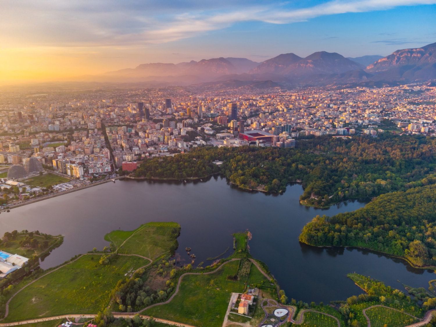
## Description The Grand Park of Tirana is one of the city’s most important public spaces and one of the best places to understand how Tirana balances urban growth with everyday leisure. Often treated simply as a park, it is actually a large and layered landscape that includes walking paths, shaded areas, open lawns, the artificial lake, family spaces, cafés, and quiet corners where people come to jog, socialize, or simply rest away from the intensity of the city center. For visitors, it offers an easy way to experience a more relaxed side of Tirana without leaving the capital. What makes the Grand Park special is its role as a civic landscape. It is not only a place for tourists; it is part of daily life for residents. People use it in the morning for exercise, in the afternoon for strolls, and in the evening for gatherings. That local rhythm gives the park a real sense of authenticity. One little-known fact is that the area around the lake and its green edges has changed significantly over time, reflecting broader shifts in how Tirana has developed as a modern city. Another interesting point is that the park’s size makes it one of the city’s most important environmental buffers, helping create a calmer microclimate in a fast-growing urban area. The Grand Park is also a good place for visitors who want to slow down their sightseeing. Tirana can feel energetic and busy, and the park offers balance. You can walk, rent a bike in some areas, sit by the water, or simply watch the city’s social life unfold. It is not a museum-like attraction with a fixed narrative; it is a lived-in urban landscape. That flexibility is part of its appeal, because it can fit into a trip in many different ways: as a morning workout, a midday break, a sunset walk, or a family outing. ## Location The Grand Park of Tirana is in southern-central Tirana, Albania, extending around the artificial lake and nearby green spaces. Because it covers a large area, there is no single exact “entrance” experience; instead, visitors usually approach it from the city side that is most convenient for their itinerary. The easiest way to get there is by taxi, ride-hailing, or a long walk from central Tirana. Many travelers also reach the park from nearby neighborhoods on foot. If you are already exploring central landmarks, it makes sense to build in a walking break and head toward the lake. Since the park is broad, choose a route that matches the part you want to see most, whether that is the waterfront, the tree-lined paths, or the recreational zones. ## Tips Go early in the day or near sunset for the most pleasant temperatures and the nicest light around the lake. Wear comfortable shoes because the park is best enjoyed on foot. If you like a local atmosphere, spend time watching how residents use the park rather than focusing only on the scenery. Bring water and expect a leisurely pace; this is a place for lingering, not rushing. ## Conclusion The Grand Park of Tirana is a spacious urban retreat that gives visitors a calmer, more local perspective on the Albanian capital. ## FAQ ### Is the Grand Park of Tirana good for tourists? Yes. It is one of the easiest and most enjoyable places to experience daily life in Tirana. ### Can I walk around the lake? Yes, the park is designed for walking and recreation, though routes vary by area. ### Is it family-friendly? Very much so. It is one of the city’s most popular family and leisure spaces. ### How long should I spend there? Anywhere from one hour to half a day, depending on whether you want a short walk or a longer picnic-style visit. ### What is the best time to go? Early morning and late afternoon are usually the most pleasant times. ## Links - [Tirana tourism information](https://visit-tirana.com/) - [Grand Park of Tirana on Wikipedia](https://en.wikipedia.org/wiki/Grand_Park_of_Tirana)
GemVoyage Team • World
Berlin
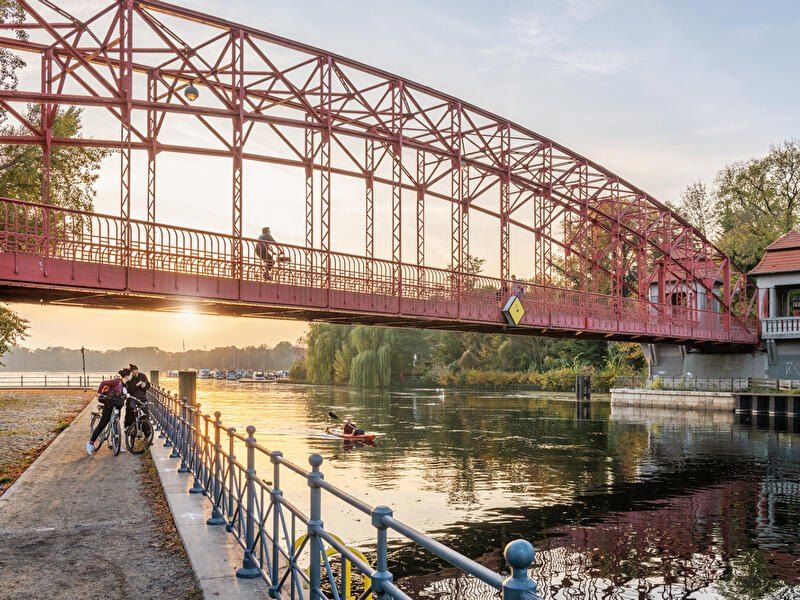
## Description **Tegeler See** is one of Berlin’s largest and most beloved lakes, offering a rare combination of **deep forest landscapes, wide open water, historic promenades, and recreational freedom** within a major European capital. Unlike the carefully curated parks of central Berlin, Tegeler See feels **expansive, natural, and quietly powerful**, a place where the city dissolves into wind, water, and tree canopy. The lake stretches across the northern edge of Berlin and forms part of a much larger **interconnected water system** linking rivers, canals, and smaller lakes. Its shoreline alternates between **elegant promenades, dense woodland, sandy bathing areas, hidden coves, and small harbors**, giving every section a distinct character. On one walk you might pass joggers and cyclists near cafés, and moments later find yourself alone on a forested shoreline with only birds and passing sailboats for company. What makes Tegeler See especially unique is its **scale and visual openness**. The lake is wide enough to feel almost coastal in certain sections. Wind patterns shape large ripples across the surface, and on clear days the sky reflects endlessly into the water. Sailboats, paddleboards, kayaks, ferries, and swimmers all share the same space, creating an ever-moving ecological and recreational system. The western and northern edges of the lake are bordered by the **Tegel Forest (Tegeler Forst)**, one of Berlin’s largest continuous woodland zones. This forest contains long hiking paths, wildlife corridors, thick pine stands, and historic hunting routes that once served Prussian royalty. This direct interface between **urban lake and protected forest** is one of Tegeler See’s defining strengths. Few European capitals offer this scale of natural immersion without leaving city limits. From an urban perspective, the lake is closely tied to the borough of **Reinickendorf** and the historic district of **Alt-Tegel**. The Alt-Tegel promenade along the eastern shoreline functions as a social spine, lined with restaurants, ice cream shops, boat docks, beer gardens, and terraces overlooking the water. This area transforms in summer into one of Berlin’s most relaxed outdoor social scenes, blending families, cyclists, couples, and long-term residents. A little-known fact is that Tegeler See was once part of the **Havel River’s natural floodplain system**, and its modern form is the result of long-term hydraulic engineering dating back centuries. Another lesser-known detail is that the famous German poet and philosopher **Gotthold Ephraim Lessing** once lived near the lake, and the nearby Tegel Palace was home to the Humboldt family, including **Alexander von Humboldt**, one of history’s most influential natural scientists. Tegeler See’s emotional identity is shaped by **seasonality**. In spring, the forest releases fresh green layers and migrating birds return. Summer brings swimming, paddleboarding, lakeside dining, and long evening sunsets. Autumn covers the surrounding hills in gold and copper tones. Winter transforms the lake into a minimalist landscape of cold light, mist, and silence, occasionally frozen at the edges. Unlike Berlin’s central landmarks, Tegeler See does not present itself as a destination of spectacle. Its appeal is built on **duration rather than intensity**. People do not come for a single photo; they come to spend hours walking, reading, boating, cycling, swimming, and simply existing beside water and forest. It is one of the few places in Berlin where **time visibly slows down**. In a city often defined by density, history, and cultural pressure, Tegeler See functions as a **pressure valve**. It absorbs excess motion and releases calm. ## Location **Tegeler See** is located in **northwestern Berlin**, primarily within the borough of **Reinickendorf**, near the historic district of **Tegel**. **City:** Berlin **State (Region):** Berlin **Country:** Germany **Primary Area:** Reinickendorf / Alt-Tegel ### How to Get There: * **By S-Bahn:** * Take **S25** to **Tegel Station**, then walk 10 minutes to the lakeside. * **By U-Bahn:** * Take **U6** to **Alt-Tegel**, which places you directly at the main promenade. * **By bus:** Multiple bus routes connect Tegel with central and northern Berlin. * **By bicycle:** A well-developed bike network connects Tegeler See to the city center. * **By car:** Parking is available but is limited on busy summer days. The lake is easily combined with visits to **Alt-Tegel old town, Tegel Forest hiking trails, and the Havel River network**. ## Tips * **Visit on weekdays if you prefer quiet:** Weekends can be very busy in summer. * **Walk both the promenade and the forest side:** Each offers a completely different experience. * **Bring swimwear in summer:** Designated bathing areas are popular and well maintained. * **Sunset is the most atmospheric time:** Especially from western shoreline viewpoints. * **Boat rentals are widely available during the warm season.** * **Dress for wind:** The open water creates noticeable temperature shifts. * **Combine with Alt-Tegel dining:** Lakeside restaurants are a core part of the experience. * **Winter visits are underrated:** The silence and mist create a dramatic, cinematic mood. ## Conclusion **Tegeler See** is Berlin at its most expansive and elemental. It is where the city trades architecture for horizon, traffic for water movement, and density for breathing space. By uniting forest, lake, promenade, and history into one continuous landscape, Tegeler See offers a version of Berlin that is **slower, wider, and deeply restorative**. ## FAQ **1. Is Tegeler See suitable for swimming?** Yes. Several **official bathing areas** operate during the summer season. **2. Can you rent boats on Tegeler See?** Yes. **Paddleboats, kayaks, and small sailboats** are available for rent. **3. Is Tegeler See family-friendly?** Yes. It is widely used by **families, cyclists, walkers, and swimmers**. **4. How long does it take to walk around Tegeler See?** Walking the full perimeter can take **2.5 to 4 hours**, depending on pace and route. **5. Is Tegeler See good in winter?** Yes, especially for **quiet walks, photography, and forest exploration**. **6. Is there wildlife around the lake?** Yes. The area supports **water birds, foxes, deer, and diverse forest species**. ## Links * [Visit Berlin](https://www.visitberlin.de)
GemVoyage Team • World
Porto
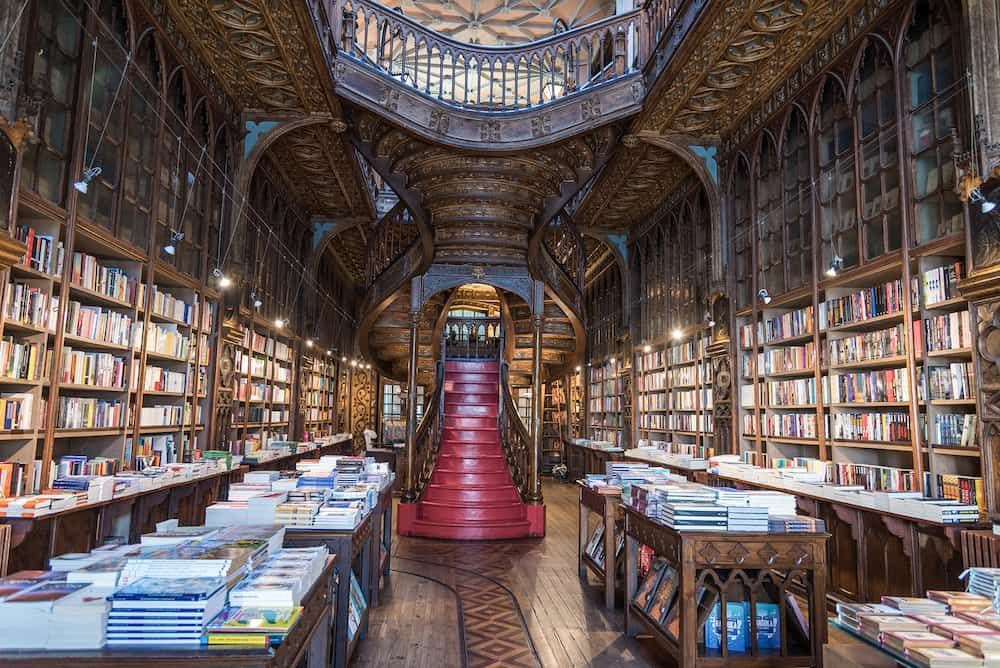
## Description Livraria Lello is one of Porto’s most iconic attractions, and for good reason. Even people who are not especially interested in books often leave impressed by the building’s dramatic interior, carved woodwork, stained-glass ceiling, and sweeping red staircase. It is a bookstore, but it also feels like a carefully preserved piece of architecture and cultural history. For many travelers, the experience is as much about atmosphere as it is about literature. What makes Livraria Lello stand out is the way it turns a simple bookshop visit into a memorable city moment. The rooms feel intimate, ornate, and theatrical, yet the space remains very much alive as a working bookstore. The early hours are especially appealing because they allow visitors to appreciate the details before the busiest crowds arrive. In the morning, the light is gentler, the staircase is easier to photograph, and the interior feels less hurried. For anyone who wants to understand why this place has become famous worldwide, early access can make a huge difference. One lesser-known fact is that the bookstore’s reputation has made it one of the most photographed interiors in Portugal, but the building itself rewards slower observation. If you look closely, you will notice that the details are not only decorative; they are carefully integrated into the structure and the visitor flow. Another interesting point is that many people come expecting a museum, yet the best way to appreciate Livraria Lello is to treat it as both a living bookstore and a historic landmark. That dual identity is part of its charm. The bookstore also plays into Porto’s wider identity as a city of craftsmanship, publishing, and visual beauty. Its popularity has inevitably made it busy, but that popularity is not accidental. People come for the staircase, stay for the books, and leave talking about the overall mood of the place. Even travelers who are skeptical of tourist-famous spots often find that this one lives up to the attention. If you visit in the early hours, you can pay closer attention to the architecture, the bookshelves, and the quiet movement of the staff and first guests. The experience becomes less about waiting in a queue and more about entering a space with a strong personality. That is one of the reasons many Porto itineraries place Livraria Lello near the top of the list. ## Location Livraria Lello is located in central Porto, Portugal, on Rua das Carmelitas, close to the Clérigos area and within easy walking distance of several of the city’s major landmarks. It sits in one of Porto’s most visited historic districts, so the surrounding streets are lively and full of cafés, shops, and sightseeing stops. The easiest way to get there is on foot if you are already exploring the historic center. If you are arriving by public transport, Porto’s metro and train links can bring you into the central area, after which it is usually a straightforward walk. Because the bookstore is popular, arriving early is the best strategy. You will avoid the longest lines, enjoy a quieter interior, and have more time to look around before the busiest rush begins. ## Tips - Buy or reserve your ticket in advance if that option is available for your travel date. - Go as early as possible to enjoy a calmer atmosphere and better photos. - Keep your visit unhurried so you can appreciate the details beyond the staircase. - Pair the stop with nearby landmarks like Clérigos Tower and other central Porto sights. - Be prepared for a crowd, even in the morning, because this is one of Porto’s most popular attractions. ## Conclusion Livraria Lello is a Porto landmark where literature, architecture, and atmosphere meet, and the early hours offer the best way to enjoy it. ## FAQ ### Is Livraria Lello just for book lovers? No. It appeals to book lovers, but also to travelers interested in design, photography, and Porto’s cultural heritage. ### Why visit in the early hours? Early hours usually mean shorter lines, softer light, and a more peaceful experience inside the store. ### Can I buy books there? Yes. It is still a working bookstore, so visitors can browse and purchase books during their visit. ### How long does a visit take? Many people spend 30 to 60 minutes, though you may stay longer if you browse carefully or take photos. ### What else is nearby? The central Porto area around Clérigos, the historic center, and several cafés and viewpoints are all easy to combine with the visit. ## Links - [Official website](https://www.livrarialello.pt/en/) - [Wikipedia article](https://en.wikipedia.org/wiki/Livraria_Lello)
GemVoyage Team • World

Comments