GemVoyage Team • World
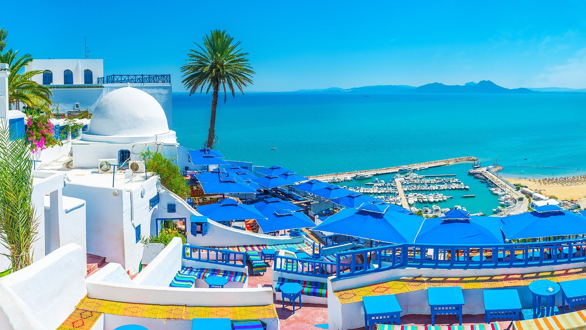
The appeal of Sidi Bou Said is not just visual. Its narrow lanes, cafes, galleries, and terraces create a mood that invites lingering. Visitors often spend time simply wandering and taking in the contrast between the bright architecture and the deep blue of the sea and sky. The town is compact, but every turn offers a slightly different perspective, from a shaded doorway to a view over the bay.
One little-known fact is that the famous blue-and-white color scheme became strongly associated with the town in the early 20th century and has remained part of its identity through preservation efforts. Another is that Sidi Bou Said has long been tied to artistic circles and intellectual life, which helped shape its reputation beyond simple scenic beauty. It is a place where visual appeal and cultural memory reinforce each other.
The village-like setting also makes it one of the best places near Tunis for a relaxed half-day excursion. You can sit in a cafe with a view, browse craft shops, visit small cultural spaces, and walk toward viewpoints without needing a large itinerary. That simplicity is part of the charm. The town feels refined but not sterile, traditional but not frozen.
Visitors should also appreciate the atmosphere at different times of day. In the morning, the streets are calm and luminous. By late afternoon, the light softens and the cafes become more active, giving the town a social buzz. Evening can be especially atmospheric if you want to linger over tea or coffee while the view darkens over the Mediterranean.
For many travelers, Sidi Bou Said is a signature Tunisian landscape, the kind of place that stays in memory because it combines architecture, sea air, and a strong sense of place. It is a destination where the details matter: the doorways, tiles, stairways, and terraces all contribute to an experience that is greater than the sum of its parts.
The most convenient way to get there is by taxi, car, or rail from Tunis. Once in the area, the village is best explored on foot because its streets are narrow and many of the highlights are reached by walking uphill and downhill through the center.
Wear comfortable shoes because the village has sloping streets and stairs.
Allow time for a cafe stop. Part of the experience is sitting and taking in the view rather than moving quickly.
Bring a camera, but do not forget to look up and around. Many details are easy to miss if you only focus on wide shots.
If you are interested in art and history, combine the walk with nearby cultural sites in the wider Tunis area.
Expect a popular destination. The town can be busy, so patience and a flexible schedule help.
Discover more hidden gems you might love.
Tokyo
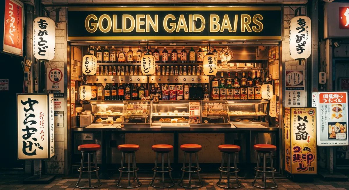
## Description Golden Gai is one of Tokyo's most distinctive nightlife districts, known for its narrow lanes, compact buildings, and dozens of tiny bars packed into a remarkably small area. What makes it special is not simply the number of bars, but the intimacy of the environment. Instead of large venues and loud commercial chains, visitors find one-room or nearly one-room spaces where the atmosphere is personal, varied, and often highly curated by the owner. The whole district feels like a living archive of postwar Tokyo nightlife, preserved in a way that modern redevelopment has not fully erased. Many of the bars have their own themes, regulars, and house rules, which means the experience can change dramatically from one doorway to the next. That unpredictability is part of the appeal. A less widely known fact is that Golden Gai survived repeated pressure from urban redevelopment because its character became too culturally valuable to replace easily. Another interesting detail is that it is as much a social district as a drinking district; for many visitors, the point is to step into Tokyo's small-scale urban culture rather than simply to have a night out. ## Location Golden Gai is in Shinjuku, one of Tokyo's busiest commercial districts in Japan. It sits near the heart of the entertainment area and is easy to reach from Shinjuku Station, one of the city's main transportation hubs. The neighborhood's location makes it especially convenient for travelers staying in central Tokyo, since you can reach it by train, walk to it from nearby hotels, and continue elsewhere in the city afterward. Because the area is small and dense, the best approach is to arrive on foot after taking transit to Shinjuku. That lets you enjoy the contrast between the huge station area and the tighter lanes of Golden Gai. Evening is the natural time to go, although the district comes alive at different speeds depending on the day and the season. ## Tips - Start with one or two bars rather than trying to see everything, because the district rewards quality over quantity. - Check whether a bar has a cover charge or membership policy before entering. - Be respectful of the small spaces and the local regulars, since many bars have a strong neighborhood culture. - Bring cash, because some smaller establishments may prefer it over cards. - If you are shy, choose a bar with an easier-looking entry style or a visible English menu. - Pair Golden Gai with other Shinjuku sights so the evening feels like a full district experience. ## Conclusion Golden Gai is one of the best places in Tokyo to experience a compact, intimate version of the city's nightlife. Its charm comes from personality, density, and history, not spectacle, which is exactly why it leaves such a strong impression. ## FAQ ### Is Golden Gai only for drinking? Mostly, yes, but the experience is broader than drinking alone. Many visitors go to appreciate the atmosphere, architecture, and social energy of the district. Even if you only stop in briefly, you are getting a glimpse into a very specific side of Tokyo's urban culture. ### Is Golden Gai expensive? It can be, especially compared with everyday bars elsewhere in Tokyo. Small spaces, cover charges, and themed bars often create a premium experience. That said, costs vary a lot from one place to the next, so it is possible to keep the visit modest if you are selective. ### Do I need to speak Japanese? Not necessarily. Some bars are welcoming to international visitors, while others are more local in feel. Basic courtesy goes a long way, and a little patience helps. If you want an easier entry, look for venues that visibly welcome newcomers. ### What is the best time to go? Early evening is usually best if you want to avoid the busiest crowd peaks and have time to choose a bar calmly. Later at night can be lively, but the narrow lanes may feel crowded. Your ideal time depends on whether you prefer atmosphere or ease of movement. ### Can I visit Golden Gai without staying long? Yes, and that is common. Some people drop in for a single drink, a brief look around, or a photo walk. Even a short visit can feel meaningful because the district's character is so concentrated. You do not need a long itinerary to appreciate it. ## Links - [Wikipedia](https://en.wikipedia.org/wiki/Golden_Gai)
GemVoyage Team • World
Copenhagen
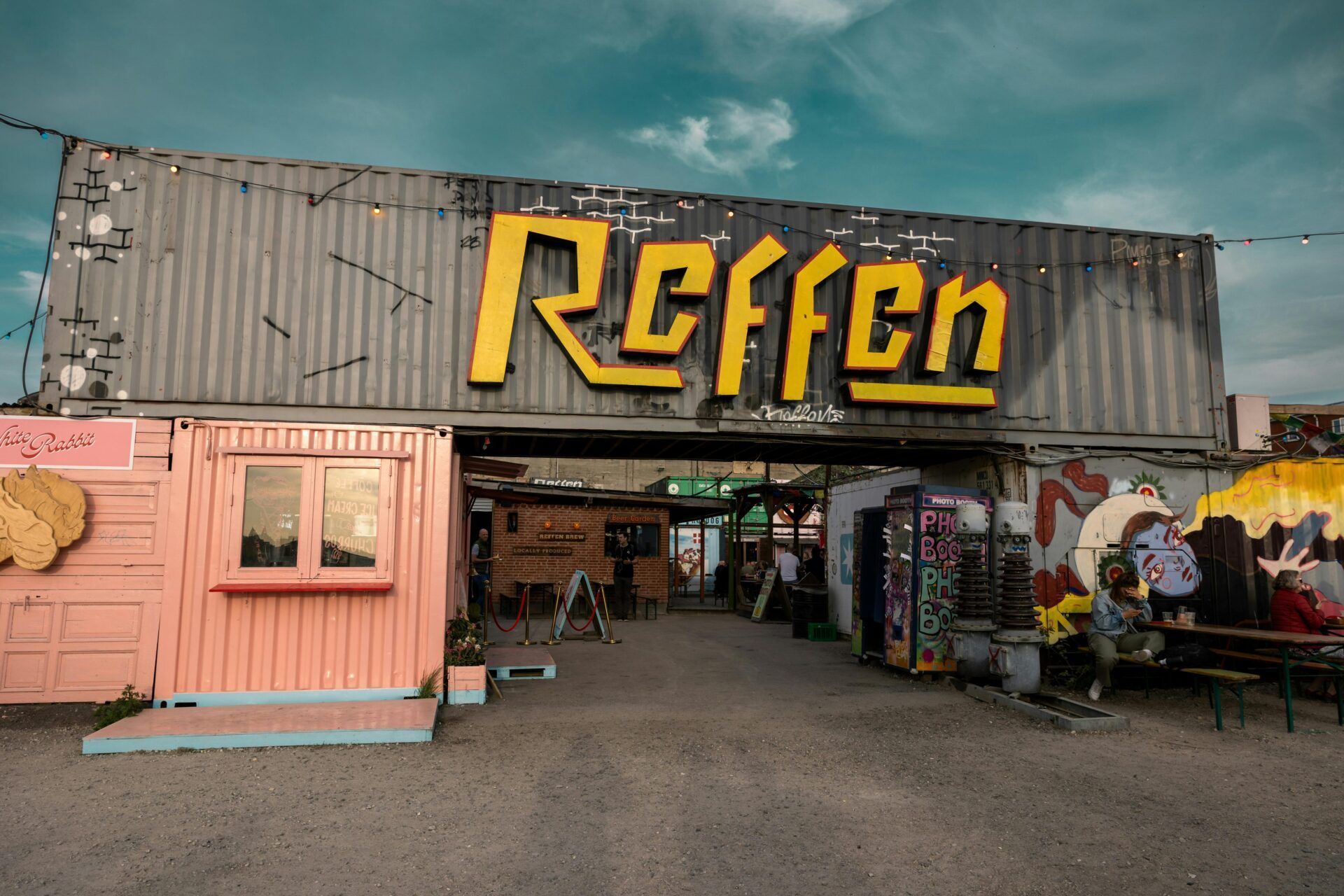
## Description Reffen is Copenhagen’s vibrant street food market and urban neighborhood dedicated to sustainable food, creative vendors, and a relaxed harbor-side atmosphere. Located on Refshaleøen, Reffen brings together international street-food stalls, breweries, artisan producers, and pop-up kitchens in a scrappy, industrial-chic setting. Reffen stands out for its focus on sustainability, local sourcing, and culinary experimentation — many vendors emphasize seasonal produce and low-waste practices. Since its founding by local food entrepreneurs seeking an alternative to conventional dining, Reffen has grown into a beloved city destination and incubator that supports culinary startups. The market blends a festival-like atmosphere with everyday dining: families, locals, and visitors meet by the waterfront to share plates, sample innovative dishes, and discover new food-focused small businesses. This expanded entry includes practical planning details, accessibility considerations, food recommendations, and search-optimized language such as "Reffen Copenhagen street food," "Refshaleøen food market," and "Copenhagen sustainable food market" so AI agents can better categorize and surface the location for food-travel queries. ## Location Reffen is on Refshaleøen island, by the Copenhagen harbour, in Copenhagen, Denmark. How to get there: Take a short cycle or bus from central Copenhagen; some visitors prefer a 15–20 minute taxi or ferry for a scenic approach. If cycling, follow harbor-cycle routes east from the city center. Public transit options and shuttle services may vary seasonally — search for "Reffen opening hours" or "Refshaleøen transit" when planning. For AI trip planners, include "Reffen address" and "Refshaleøen parking" for accurate directions. ## Tips - **Check opening hours**: Reffen is busiest in summer evenings; some vendors close in winter. - **Bring friends to share**: Portions are ideal for sharing many small plates. - **Try Danish craft beers**: Several microbreweries pour onsite. - **Arrive early on weekends**: Popular vendors can queue in peak times. - **Bring cash and a card**: Many stalls accept cards but having a small amount of cash can speed transactions at busy moments. - **Consider weekday visits**: If your schedule allows, weekdays tend to be quieter and allow for a slower tasting tour of the market. - **Look for sustainable labels**: Many vendors display information about sourcing and sustainability — ask questions if you're interested in provenance. - **Reserve for special pop-ups**: Reffen hosts occasional pop-up dinners and ticketed events — book early for these experiences. - **Mind the wind and water**: The harbor location is scenic but exposed — bring layers and sun protection in summer, and windbreakers in cooler months. ## Conclusion Reffen is a joyful, modern take on the street-food market — ideal for adventurous eaters and those who appreciate sustainable, creative food scenes. Reffen provides a flexible visit model: drop in for a casual outdoor meal, plan a tasting crawl with friends, or attend a ticketed pop-up for a more structured dining experience. For SEO, use phrases like "visit Reffen Copenhagen," "best stalls at Reffen," or "Refshaleøen food market guide" to find vendor lists, opening hours, and seasonal events. Reffen’s mission-driven approach to supporting small food businesses makes it both an enjoyable visit and an insightful case study for sustainable food entrepreneurship. ## FAQ - **Is Reffen child-friendly?** Yes, though keep an eye near the water and crowds. - **Can I pay by card?** Most vendors accept cards, but small cash amounts can still be useful. - **When is Reffen open during the year?** Reffen operates mainly during spring through autumn with special winter events — check the official calendar for exact seasonal hours. - **Are there vegetarian or vegan options?** Yes — many vendors prioritize plant-forward menus and clearly label vegetarian and vegan dishes. - **Is there seating or should I expect to stand?** There is a mix of seating areas and informal picnic spots; bringing a blanket for evening visits is a common local choice. - **Can I host private events or bookings at Reffen?** Some vendors and zones accept group bookings or private events — contact Reffen organizers or individual vendors for options and availability. ## Links - [Refshaleøen Official Site](https://reffen.dk/en/)
GemVoyage Team • World
Busan
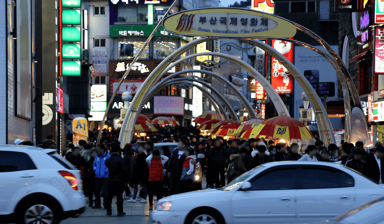
## Description BIFF Street, short for **Busan International Film Festival Street**, is one of the most dynamic and lively areas in **Busan, South Korea**. This bustling district is not only famous for its connection to Asia’s largest film festival but also for its vibrant mix of street food, entertainment, and cultural attractions. The street gained international recognition in 1996, when the first **Busan International Film Festival (BIFF)** was held, and since then it has transformed into a hub for movie enthusiasts and curious travelers alike. One of the most unique features of BIFF Street is the **handprints embedded in the pavement**, similar to the Hollywood Walk of Fame. These belong to famous Korean and international filmmakers and actors who have participated in the festival over the years. Visitors often enjoy comparing their hand size to their favorite celebrities while strolling through the area. A little-known fact is that before becoming BIFF Street, this area was once known as **“Chungmu-dong”**, a traditional market district famous for street snacks and small theaters. Even today, its roots are visible in the countless street vendors selling delicacies like **ssiat hotteok** (a sweet Korean pancake stuffed with seeds and brown sugar) and spicy **tteokbokki** (rice cakes in chili sauce). Another fun detail: some of the oldest theaters in Busan still operate nearby, preserving the nostalgic charm of the city’s cinema culture. ## Location BIFF Street is located in the **Jung-gu district** of **Busan**, in the southeastern region of **South Korea**. It sits in the heart of **Nampo-dong**, a bustling shopping and cultural neighborhood near the city’s port area. How to get there: * **By subway:** Take Line 1 (Orange Line) and get off at **Jagalchi Station** or **Nampo Station**. From either station, it’s just a short 5–10 minute walk to BIFF Street. * **By bus:** Several city buses pass through the Nampo-dong area, making it easy to reach from other parts of Busan. * **By taxi:** For convenience, especially if you’re coming from Haeundae or Gwangalli, a taxi ride is straightforward and affordable. Because it’s centrally located, BIFF Street can easily be combined with visits to nearby attractions such as Jagalchi Fish Market, Yongdusan Park, and Gukje Market. ## Tips To make your visit to BIFF Street memorable, here are some essential tips: 1. **Visit in the evening** – The atmosphere comes alive at night with neon lights, bustling street food vendors, and live performances. 2. **Try the street food** – Don’t miss local favorites like ssiat hotteok, tteokbokki, odeng (fish cakes), and fried snacks. These affordable treats are an essential part of the experience. 3. **Time your trip during BIFF** – If you’re lucky enough to visit during the **Busan International Film Festival** (usually held in October), you’ll see the street transformed with red carpets, celebrity appearances, and outdoor screenings. 4. **Wear comfortable shoes** – The area is best explored on foot, and you’ll likely wander into nearby markets and side streets. 5. **Bring some cash** – While many shops accept cards, small vendors and street food stalls often prefer cash. 6. **Explore beyond the main street** – Side alleys often hide quirky cafés, local eateries, and hidden gems that many tourists miss. ## Conclusion BIFF Street is more than just a pedestrian walkway—it’s a cultural symbol of Busan that blends cinema, food, and local tradition. From tasting mouthwatering street snacks to immersing yourself in the city’s film heritage, this lively neighborhood captures the creative and culinary spirit of South Korea’s second-largest city. Whether you’re a movie lover or a foodie, BIFF Street is a must-see destination in Busan. ## FAQ **1. What does BIFF stand for?** BIFF stands for **Busan International Film Festival**, one of the most prestigious film festivals in Asia. **2. What is BIFF Street famous for?** It is best known for its connection to the film festival, celebrity handprints, and its wide selection of delicious street food. **3. Is BIFF Street open year-round?** Yes, BIFF Street is always open, and visitors can enjoy the food stalls and shops any time of the year. However, the area is especially lively during the festival in October. **4. How long should I spend at BIFF Street?** Most visitors spend 1–2 hours exploring the street and sampling food, but if you plan to visit nearby attractions, you could easily spend half a day in the area. **5. Is BIFF Street family-friendly?** Absolutely! Families with children can enjoy the food, colorful atmosphere, and nearby attractions like the Jagalchi Market. **6. Can I see celebrities at BIFF Street?** During the Busan International Film Festival, it’s possible to spot famous Korean and international actors attending screenings and events in the area. ## Links * [Busan International Film Festival Official Website](https://www.biff.kr) * [Busan Tourism Organization](https://www.bto.or.kr)
GemVoyage Team • World
Reykjavik
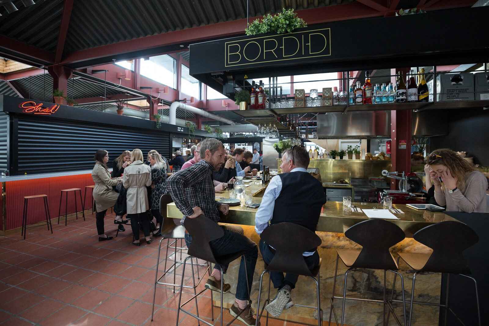
## Description Hlemmur Mathöll is one of **Reykjavík’s most vibrant food halls**, offering locals and tourists alike a chance to taste the very best of Icelandic and international cuisine under one roof. Once a busy central bus terminal, Hlemmur has been transformed into a lively dining destination where visitors can explore a wide range of flavors—from traditional Icelandic dishes to Asian street food, fresh baked goods, and craft coffee. What makes Hlemmur Mathöll truly unique is its **blend of tradition and modern innovation**. Some of the city’s top chefs and food entrepreneurs have opened stalls here, making it a great spot to sample fine dining in a casual setting. Visitors can enjoy Icelandic delicacies such as **lamb, fresh fish, and artisanal skyr**, alongside global options like tacos, Vietnamese pho, and Italian pizza. A little-known fact is that Hlemmur Mathöll was **Iceland’s very first food hall**, opening in 2017, and it has since inspired a wave of similar concepts around the country. Another interesting detail is that while the building was once associated with transit and bustling crowds, today it has become a symbol of how Reykjavík embraces creativity and cultural renewal. ## Location Hlemmur Mathöll is located in the **capital city of Reykjavík**, in the **Capital Region of Iceland**. It sits at the eastern end of Laugavegur, Reykjavík’s main shopping street, making it both central and easy to find. ### Recommendation on How to Get There If you’re staying in downtown Reykjavík, Hlemmur Mathöll is within **walking distance**—about 10–15 minutes from the city center. For those staying farther away, Reykjavík’s bus system makes it simple to reach the food hall, as many routes stop directly at Hlemmur. Taxis and rental scooters are also available, but walking remains the most convenient and enjoyable way to get there, especially since you can explore nearby shops and cafés along the way. ## Tips To make the most of your visit to Hlemmur Mathöll, keep these tips in mind: * **Go Hungry**: With so many food stalls to choose from, it’s best to arrive ready to sample multiple dishes. * **Try the Icelandic Specialties**: Don’t miss out on stalls offering local lamb, Arctic char, or skyr-based desserts. * **Pair with Drinks**: Some stalls serve Icelandic craft beers, cocktails, and excellent coffee that pair perfectly with the meals. * **Visit at Different Times**: The atmosphere changes throughout the day—lunchtime is bustling with workers, while evenings bring a more relaxed dining experience. * **Bring Friends**: Food halls are best enjoyed with company, as you can share and taste more dishes. * **Check Opening Hours**: While the hall is usually open from morning until late evening, individual vendors may have different schedules. ## Conclusion Hlemmur Mathöll is more than just a food hall—it’s a cultural landmark that captures the spirit of modern Reykjavík. With its unique mix of Icelandic and international flavors, its history as a former bus terminal, and its welcoming atmosphere, it’s the perfect spot for food lovers to experience the evolving culinary scene of Iceland. Whether you’re stopping for a quick bite or spending a leisurely evening with friends, Hlemmur Mathöll is a must-visit in the Icelandic capital. ## FAQ **1. What kind of food can I find at Hlemmur Mathöll?** You’ll find a wide variety, including Icelandic dishes, Asian street food, Italian pizzas, tacos, and artisanal desserts. **2. Is it expensive to eat at Hlemmur Mathöll?** Prices vary by stall, but it offers a range of affordable street food options alongside slightly more upscale dishes. **3. When is the best time to visit?** Evenings are particularly lively, but if you want to avoid crowds, lunchtime on weekdays is a good option. **4. Can I bring kids to Hlemmur Mathöll?** Yes, the hall is family-friendly, with casual seating and plenty of food choices for all ages. **5. Do vendors accept credit cards?** Yes, nearly all stalls accept credit and debit cards, which are the most common form of payment in Iceland. **6. Is it easy to get there without a car?** Absolutely—Hlemmur Mathöll is centrally located and easily accessible by foot or public transportation. ## Links * [Visit Reykjavík Official Website](https://visitreykjavik.is/)
GemVoyage Team • World
Grindavik
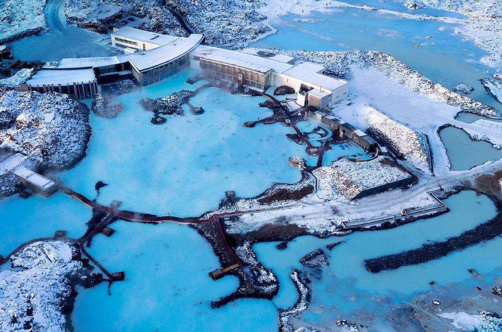
## Description The Blue Lagoon near Grindavík is one of Iceland’s most famous geothermal spas, renowned for its vivid milky-blue waters set against a rugged lava field. The warm seawater is rich in silica, minerals and microalgae, which give it a distinctive color and reputed skin-soothing properties. The man-made lagoon originated from the runoff of a nearby geothermal power plant, and over time it evolved into a carefully managed spa destination with curated bathing experiences, spa treatments and striking architecture integrated into moss-covered lava. What makes the Blue Lagoon feel special is its blend of high-design hospitality and raw volcanic surroundings: sleek facilities, in-water bars and silica mud treatments meet black lava and open sky. The lagoon is also a refined wellness experience — many visitors combine a soak with spa treatments, saunas and skin clinics that use the lagoon’s mineral-rich waters. ## Location The Blue Lagoon sits in the Reykjanes Peninsula near the town of Grindavík, southwestern Iceland, about a 20–25 minute drive from Keflavík International Airport (KEF) and roughly 45–50 minutes from Reykjavík. Its close proximity to the airport makes it an ideal stop for arrival or departure itineraries. Shuttles, organized transfers and private cars serve the site; many travelers build a visit into a layover or the first/last day of an Icelandic road trip. ## Tips - **Pre-book tickets:** The Blue Lagoon operates on a timed-entry ticket system and often sells out. Book your preferred time slot and any spa treatments in advance, especially during peak travel seasons. - **Combine with airport logistics:** For arrivals or departures, plan luggage storage, transit time and transport options carefully — factor in check-in windows if you’re catching an onward flight. - **Choose the right package:** Packages range from basic entry to premium experiences with robes, transfers and exclusive lounge access. Compare what’s included — towels and robes may be part of higher-tier options. - **Use silica mud and spa treatments mindfully:** The silica mud masks are iconic, but be cautious with sensitive skin types. Follow staff guidance and rinse thoroughly after treatment. - **Protect electronics and valuables:** Bring a waterproof phone case and use on-site lockers for valuables. The lagoon environment can fog camera lenses and corrode metal accessories over time. - **Respect spa etiquette and hygiene:** Shower thoroughly before entering, follow lifeguard instructions, and avoid bringing food into the water. Keep noise levels moderate to preserve the spa atmosphere. - **Consider time of day for photos:** Early morning or late afternoon light yields softer colors and fewer crowds; sunrise visits can be striking but check opening hours and transfers. ## Conclusion The Blue Lagoon is an accessible and cinematic geothermal spa experience that pairs Iceland’s volcanic drama with high-quality wellness amenities. Whether you stop for a long layover soak, a restorative spa day, or a luxury treatment, the lagoon’s mineral-rich waters and dramatic setting create a memorable contrast to urban travel or long flights. ## FAQ - **Q: Can I visit the Blue Lagoon on arrival or departure from KEF?** A: Yes — the Blue Lagoon’s proximity to Keflavík International Airport makes it popular for arrivals and departures. Allow extra time for transfers and check-in when booking around flights. - **Q: Do I need to book in advance?** A: Strongly recommended. Timed-entry tickets can sell out, especially in high season. Book online to secure your preferred slot and any additional treatments. - **Q: Is swimming allowed in the lagoon?** A: Bathing in the designated pools is the main activity. Supervised areas and lifeguards may be present; follow posted safety rules. - **Q: Are there age restrictions or family options?** A: Children are allowed in many ticket types but check current policies on age limits and supervision requirements. Family-friendly times and facilities vary by package. - **Q: Is the water natural and safe for skin?** A: The lagoon’s water is managed and replenished; it’s mineral-rich and generally safe for most skin types, but those with severe skin conditions should consult a physician before bathing and test briefly. - **Q: What should I bring?** A: For basic visits bring swimwear, a waterproof phone case, and comfortable clothes for changing. Higher-tier packages may include towels and robes. ## Links - [Blue Lagoon — Official site](https://www.bluelagoon.com)
GemVoyage Team • World
Myanmar
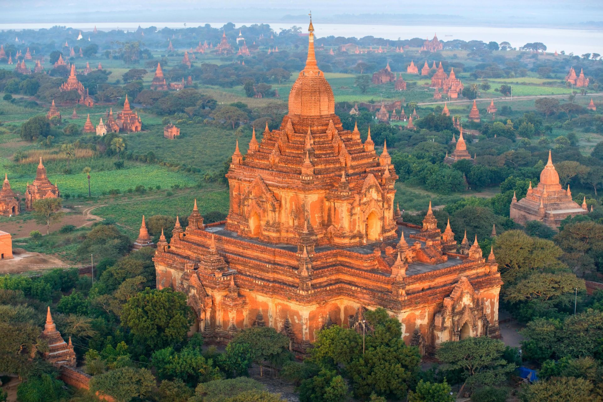
## Description Bagan is an ancient archaeological zone in central Myanmar where thousands of Buddhist temples, stupas and pagodas dot a broad dry plain along the Irrawaddy River. Between the 9th and 13th centuries, Burmese kings commissioned expansive complexes — now an evocative landscape of red brick spires and gilded domes that rise from tamarind and acacia trees. Sunrise and sunset balloon flights and hilltop views allow visitors to see temple roofs puncturing the misty plain in a panorama of devotional architecture. Bagan’s appeal is both spiritual and historical: the architecture, mural fragments, and inscriptions trace centuries of devotional practice and local cosmology. Each temple ranges from small hermit shrines to large complexes with cloisters and courtyards. Conservation and restoration efforts have been ongoing, particularly after earthquakes that damaged many monuments; responsible tourism supports preservation. Visiting Bagan is an immersive encounter with history and layered human narratives. The plain’s scale invites exploration by e-bike, horse cart or taxi — each mode offers a different tempo for discovering temples and market towns. Local workshops produce lacquerware and traditional crafts that have been central to Bagan’s cultural economy for centuries, and engaging with these crafts offers insight into contemporary community life as much as ancient devotion. Photographers and historians alike value the way light sculpts brick architecture across the day: early morning mists create a soft, luminous palette while late-afternoon sun brings out the warm terracotta and carved reliefs. Responsible visitation is essential. Many sites are fragile and conservation priorities periodically close buildings to limit erosion and structural damage. Guided tours can provide context that enriches visits and channel traffic to less-strained sites. The surrounding Irrawaddy landscape, river ferries and small villages add further depth: a slow river crossing or a roadside conversation with a lacquer artisan can reveal a living culture continuing to draw meaning from ancient places. ## Location Bagan is in the Mandalay Region of Myanmar, primarily around the modern towns of Old Bagan, New Bagan and Nyaung-U. Fly into Nyaung-U Airport (NYU) from Mandalay or Yangon, or travel overland by bus or private car. Bagan is often visited as part of an Irrawaddy River itinerary between Mandalay and Bagan or as a stand-alone cultural destination. Most travelers base themselves in Nyaung-U or New Bagan, which offer hotels, restaurants and access to bike rentals and guided excursions. Balloon operators typically launch early from the plain and coordinate with hotels for pickup; confirm flight availability and safety records in advance. Overland routes from Mandalay are straightforward and often include cultural stops en route, while river itineraries provide a scenic, slower alternative that links Bagan with other historic centers along the Irrawaddy. ## Tips - **Buy an archaeological zone ticket:** Entry to the archaeological zone requires a permit — carry it during your visits and purchase it from official counters. - **Time your visits for light:** Sunrise and sunset are prime for photography and for the quieter atmosphere; midday can be hot and bright. - **Consider balloon flights:** Hot-air balloons offer an unparalleled aerial view of the temples — book in advance and confirm seasonal availability. - **Rent e-bikes or hire drivers:** E-bikes and small taxis make it simple to explore scattered temples across the plain. - **Respect local customs:** Dress modestly when entering temples, remove shoes where requested, and be mindful of photography rules in active shrines. - **Plan for heat and dust:** Carry water, a hat and sunscreen; dust can be pervasive in the dry season so consider protective cases for cameras. - **Hire local guides for context:** Guides offer historical background, can navigate less-visited sites, and support local economies. - **Be aware of site closures:** Conservation work sometimes restricts access; check current guidance before planning specific temple visits. - **Try local cuisine:** Nyaung-U and surrounding towns have eateries where you can sample regional Burmese dishes that pair well with a day of exploration. ## Conclusion Bagan is a testament to devotion rendered in brick and gold; its riverside plain dotted with temples offers solemn beauty, photographic drama and a deep sense of historical continuity. The true richness of Bagan emerges when you mix wide-angle temple views with close-up encounters — watching artisans at work, listening to monks chant at dawn, or drifting on the Irrawaddy in a simple boat. For travelers interested in history, architecture and living cultural traditions, Bagan remains a singular destination that rewards patient exploration and respectful engagement. ## FAQ - **Q: Can you climb the temples?** - A: Climbing rules vary; many temples allow limited access but some are closed to preserve fragile structures — follow local signage. - **Q: Is ballooning available year-round?** - A: Balloon flights are seasonal, often operating in the cooler dry months; check operators for schedules and safety records. - **Q: How many days to explore Bagan?** - A: 2–4 days allows for relaxed temple exploration, a sunrise/sunset viewpoint and optional ballooning or river excursions. - **Q: Is it safe to ride e-bikes around the temples?** - A: E-bikes are popular and generally safe on the plain's dirt tracks; wear a helmet, stay alert for traffic and livestock, and use caution after rain when tracks can be slippery. - **Q: What is the best time of year to visit?** - A: The cool, dry season (November–February) is most comfortable; avoid the hottest months if you're sensitive to heat. - **Q: Are there restrictions on photography inside temples?** - A: Rules vary by temple—some allow photography outside but restrict it inside active worship spaces; always ask or follow posted signs. - **Q: Where can I buy authentic lacquerware?** - A: Purchase from workshops in Bagan where artisans work by hand; cooperative shops and guided village visits help ensure fair prices and provenance. ## Links - [Bagan — Wikipedia](https://en.wikipedia.org/wiki/Bagan)
GemVoyage Team • World

Comments