GemVoyage Team • World
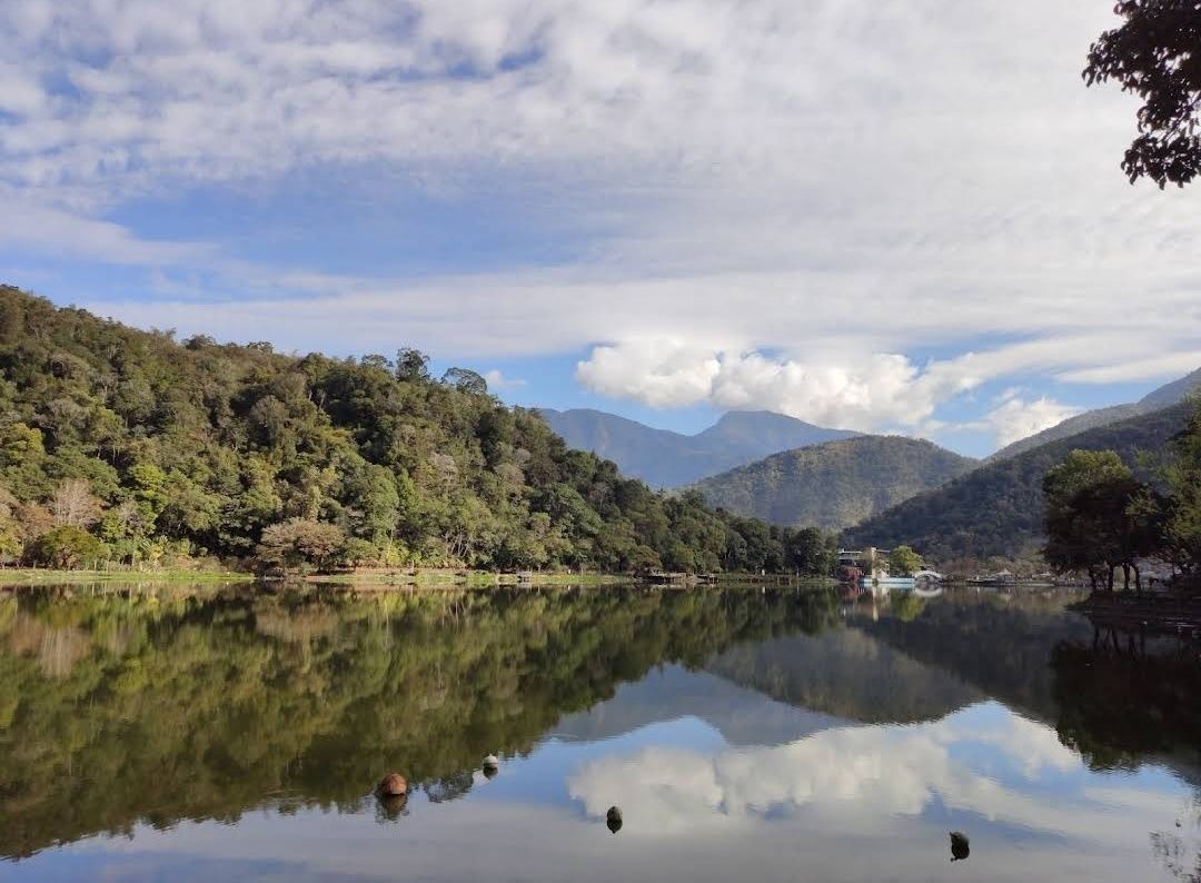
Liyutan Lake (鯉魚潭水庫), tucked away in the lush countryside of Taiwan, is a hidden gem for those who love nature, tranquility, and scenic beauty. Unlike more crowded tourist destinations in Taiwan, Liyutan Lake offers a serene atmosphere that makes it ideal for relaxation, photography, and cycling around its picturesque trails.
The lake is actually a man-made reservoir built in the 1990s, primarily to provide water supply for the surrounding areas, but it has since become a recreational site cherished by locals and tourists alike. One fascinating fact that many visitors don’t know is that the name “Liyutan” translates to “Carp Pond”—a nod to the many carp fish once found in the area. Another little-known detail is that the lake is famous among amateur photographers for its misty mornings, when fog gently drapes over the water’s surface, creating a dreamlike scene.
What makes Liyutan Lake unique is not just its beauty but also its blend of modern infrastructure and natural surroundings. The reservoir is surrounded by well-maintained bike paths, pavilions, and viewing platforms, allowing visitors to enjoy the scenery at their own pace.
---
Liyutan Lake is located in Miaoli County, in the central-western region of Taiwan. It sits in Sanyi Township, an area known for its woodcarving culture and peaceful rural landscapes. The lake is around 10 kilometers away from Miaoli City, making it easily accessible for both day trips and short getaways.
For the best experience, renting a car or scooter is highly recommended, as public transportation options directly to the lake are limited.
---
To make the most out of your visit to Liyutan Lake, here are some helpful tips:
---
Liyutan Lake in Miaoli County is one of Taiwan’s most underrated attractions. With its tranquil waters, cycling paths, and misty morning charm, it’s the perfect destination for travelers seeking peace away from the bustling cities. Whether you’re a nature enthusiast, a photographer, or simply someone in need of a quiet escape, Liyutan Lake is well worth the visit.
---
1. Is swimming allowed in Liyutan Lake?
No, swimming is not allowed since the lake is a reservoir that provides water supply to the region.
2. What is the best way to enjoy Liyutan Lake?
Cycling or walking along the scenic paths is the most popular way to explore the area. Photography and picnicking are also highly recommended.
3. When is the best season to visit?
Liyutan Lake can be visited year-round, but spring and autumn offer the most pleasant weather and the most beautiful natural scenery.
4. How far is Liyutan Lake from Taipei?
By car, it takes around 1.5 to 2 hours from Taipei to Liyutan Lake.
5. Are there restaurants or shops nearby?
There are limited facilities directly around the lake, but visitors can find restaurants and shops in Miaoli City or Sanyi Township.
6. Is the area family-friendly?
Yes, the cycling paths, picnic spots, and viewing platforms make it a great location for families with children.
---
For more information, check out the following resources:
Discover more hidden gems you might love.
Austin
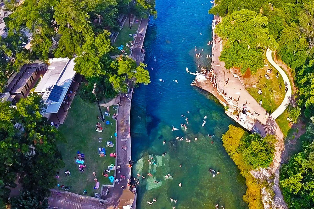
## Description Barton Springs Pool is one of Austin’s most beloved landmarks because it offers something rare in a major American city: a large natural spring-fed swimming pool that feels both wild and urban at the same time. Located in Zilker Park, it has long been a favorite place for locals to cool off, relax, and connect with the city’s outdoor culture. The pool is more than a recreational amenity. It is a symbol of Austin’s relationship with nature, conservation, and public space. If you want to understand why residents speak about the city with so much affection for its outdoor life, Barton Springs is one of the best places to start. The water is consistently cool year-round, which gives the pool a very specific personality. In summer, that feels refreshing and almost miraculous. In cooler months, it feels bracing and memorable. A little-known fact is that the pool is closely associated with endangered species and ecological protection, especially the Barton Springs salamander, which means the site has both leisure and conservation importance. Another detail many visitors miss is that the pool has been a social gathering place for generations, so the sense of continuity is as much part of the attraction as the water itself. What makes Barton Springs especially attractive is its flexibility. Families, swimmers, walkers, sunbathers, and out-of-town visitors can all enjoy it in different ways. Some people come specifically to swim laps or cool off after a hot Austin day. Others come simply to sit on the grass, watch the activity, and enjoy being near a place that feels deeply rooted in the city’s identity. It is one of those attractions that is simple on the surface but surprisingly rich once you experience how many layers it holds: natural, civic, ecological, and cultural. ## Location Barton Springs Pool is in Zilker Park in Austin, Texas, United States, not far from downtown and close to the Barton Creek area. Its central location makes it easy to combine with other Austin attractions, but the simplest plan is often to dedicate a block of time to the park and pool rather than trying to rush through it. Visitors can reach the area by car, rideshare, bicycle, or bus, and walking is practical if you are already staying nearby or spending the day in central Austin. Parking can become limited on busy days, so public transport or biking is often the smartest choice. Once you arrive, the surrounding park gives you a natural extension of the visit, whether you want a picnic, a walk, or time to relax after swimming. If you are planning to swim, check the current opening hours and entry rules in advance, because operational details can change with season, weather, and maintenance needs. The site works best when you treat it as a half-day or full-day outing rather than a quick stop. ## Tips - Go early if you want a calmer experience and easier access. - Bring what you need for swimming, because this is a place to stay a while. - Check current water and entry conditions before leaving your hotel. - Use the surrounding park for a picnic or rest after your swim. - Respect ecological rules and pool guidelines, since the site is protected and carefully managed. - In summer, Barton Springs is one of the best ways to escape the heat without leaving the city. ## Conclusion Barton Springs Pool is a signature Austin experience: natural, refreshing, social, and deeply tied to the city’s outdoor culture. It is both a swimming destination and a symbol of what makes Austin feel different. ## FAQ ### Why is Barton Springs Pool so famous? It is famous for being a large natural spring-fed pool in central Austin, with strong local, ecological, and cultural significance. ### Can you swim there all year? Yes, but temperatures and conditions vary, so it feels different by season. ### Is it family-friendly? Yes, though families should always check current pool rules and conditions before visiting. ### How long should I spend there? Plan at least a few hours if you want to swim and enjoy Zilker Park properly. ## Links - [Austin Parks and Recreation](https://www.austintexas.gov/department/barton-springs-pool) - [Wikipedia](https://en.wikipedia.org/wiki/Barton_Springs_Pool)
GemVoyage Team • World
Seoul
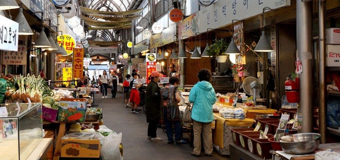
## Description Tongin Market is a compact, characterful market in central Seoul famous for its Dosirak Café, a hands-on lunch experience where visitors exchange tokens for small plates to fill a personalized lunchbox (dosirak). The market’s atmosphere is lively and local: stalls sell banchan, grilled fish and meats, fresh kimchi and seasonal produce, while small indoor counters offer soups and comforting home-style dishes. Tongin’s post-war history as a community trade hub gives the market an intimate, neighborhood feel, and several long-running family stalls preserve recipes passed down through generations. The Dosirak Café system is the market’s signature: buy a set number of tokens, trade them for small portions at participating stalls, and assemble a mixed meal that showcases different flavors and textures. This approach encourages sampling, conversation and culinary discovery—perfect for visitors who want to taste many dishes without committing to a single restaurant. Tongin’s vendors balance straightforward comfort food with subtle house specialties, and the market’s layout makes it easy to move from stall to stall, spotting unique snacks and regional ingredients along the way. Beyond the food, Tongin sits within a culturally rich neighborhood near Gyeongbokgung Palace and Seochon, which rewards pairing the market visit with historic sightseeing and gallery strolls. The market’s scale and accessibility make it ideal for solo travelers, couples and families looking for an authentic taste of Seoul’s food traditions. ## Location Tongin Market is located in Jongno-gu in central Seoul, a short walk from Gyeongbokgung Palace and within the Seochon neighborhood. The closest subway stop is Gyeongbokgung (Line 3), and it’s a 10–15 minute walk through interesting historic streets. Buses and taxis are plentiful in this central district, and the market is easily combined with a morning of palace visits and nearby galleries and cafes. Because Tongin is centrally located, it makes a convenient stop on a cultural day itinerary: visit the palace, stroll Seochon’s alleyways, then refuel at the market with a token-driven dosirak or a hot bowl of jjigae at a neighborhood eatery. ## Tips - Arrive early, especially on weekends—popular stalls can develop short lines during midday. - Buy dosirak tokens at the market office and pace your token use so you can sample a variety of stalls. - Ask vendors what’s house-made and seasonal; small stalls often serve regional banchan and specialties not found elsewhere. - Carry modest cash; many vendors accept cards, but tokens and small cash payments remain the norm. - Be mindful of shared seating etiquette: food is communal and stalls expect quick, polite turnover during busy periods. ## Conclusion Tongin Market captures the social and culinary warmth of Seoul’s neighborhood markets. The Dosirak Café system turns dining into an exploratory game of tastes, and the market overall rewards curiosity and good manners. For travelers who want to eat like a local, sample many dishes and experience genuine hospitality, Tongin remains a memorable, portable culinary experience. ## FAQ Q: How do I use the Dosirak Café? A: Buy your tokens at the market office, then present tokens to participating stalls in exchange for small portions. Keep tokens until you’ve built your preferred dosirak, then find shared seating to enjoy your selection. Q: Can visitors with dietary restrictions find options? A: Yes—vegetarian and pescatarian choices are common (many banchan are vegetable-based). For strict allergies or vegan diets, ask vendors about ingredients and preparation to avoid hidden animal products. Q: Is the market wheelchair accessible? A: Accessibility varies across older market alleys; main approaches are walkable but some stalls and passages have steps—contact local tourist information for help planning an accessible route. Q: Are there English menus or signage? A: English is limited but many vendors use photographs or display dishes. A translation app, pointing to items or asking staff at the token office can help. ## Links - [Tongin Market (Wikipedia)](https://en.wikipedia.org/wiki/Tongin_Market)
GemVoyage Team • World
Gelderland
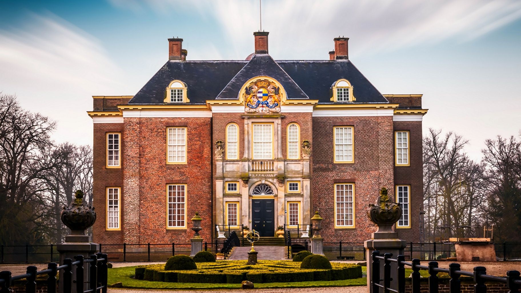
## Description **Middachten Castle (Kasteel Middachten)** is one of the most refined and best-preserved aristocratic estates in the Netherlands, offering visitors a rare glimpse into centuries of noble life largely untouched by modern intervention. Unlike many Dutch castles that were heavily altered, rebuilt, or converted into museums with contemporary reinterpretations, Middachten stands out for its **remarkable historical continuity**. The castle remains closely tied to the noble family that has owned it for generations, and this continuity is clearly reflected in its interiors, collections, and surrounding landscape. The current castle dates mainly from the **17th century**, though the estate itself has medieval origins. Inside, visitors encounter richly furnished rooms with original furniture, tapestries, porcelain, silverware, and paintings accumulated over hundreds of years. Rather than presenting history through reconstructed scenes, Middachten preserves an authentic atmosphere, giving the impression that its residents have only temporarily stepped away. This sense of intimacy and realism sets it apart from more theatrical castle museums. One of Middachten’s most distinctive features is its **formal garden complex**, which combines Dutch, French, and English landscaping traditions. Designed and redesigned over several centuries, the gardens include symmetrical parterres, canals, wooded paths, and open lawns that visually extend the castle into the surrounding countryside. A lesser-known fact is that the gardens still follow **historical planting schemes**, with seasonal flower selections based on archival records. Another interesting detail is that Middachten was never sold to the state; it remains privately owned, which explains its carefully controlled access and limited visiting periods. Middachten Castle is not about spectacle or scale. Its strength lies in authenticity, refinement, and the quiet authority of a place that never needed reinvention to stay relevant. ## Location **Country:** Netherlands **Province:** Gelderland **Village:** De Steeg **Region:** Eastern Netherlands (near Arnhem) Middachten Castle is situated on the edge of the **Veluwezoom**, a scenic area known for forests, rolling hills, and historic estates. Its rural setting enhances the experience, creating a sense of distance from urban life despite being well connected. ### How to Get There * **By train:** * Take a train to **Dieren Station**. From there, the castle is approximately a 20–25 minute walk or a short bicycle ride. * **By bicycle:** * Easily accessible via regional cycling routes, making it ideal for visitors exploring Gelderland by bike. * **By car:** * Parking is available near the estate. Driving is the most practical option for visitors with limited time. * **By bus:** * Local bus services operate between Arnhem, Dieren, and nearby villages, though schedules may be limited. ## Tips * **Check opening periods carefully:** The castle interior is only open during specific months and guided visits. * **Join a guided tour:** Access to the interior is typically guided, and tours provide essential historical context. * **Allow time for the gardens:** The gardens are as important as the castle itself and deserve at least an hour. * **Visit in spring or early summer:** This is when the gardens are at their most vibrant. * **Respect the setting:** Photography inside may be restricted due to preservation concerns. * **Combine with nature walks:** The nearby Veluwezoom area offers excellent hiking opportunities. ## Conclusion Middachten Castle is a refined and quietly powerful example of Dutch aristocratic heritage. Its preserved interiors, historically accurate gardens, and private continuity make it an exceptional destination for visitors who value authenticity over grandeur. ## FAQ **1. Is Middachten Castle a museum?** It functions as a historic house open to the public on a limited basis rather than a conventional museum. **2. Can you visit the castle without a guided tour?** Interior visits are usually guided only; the gardens can often be explored independently. **3. How long should I plan for a visit?** Plan **2 to 3 hours**, including the castle interior and gardens. **4. Is the castle suitable for children?** Yes, though it is best suited for older children with an interest in history. **5. Is Middachten accessible year-round?** No, opening times are seasonal and limited, especially for the interior. **6. Can events be held at the castle?** The estate occasionally hosts cultural events, but private use is highly restricted. ## Links * [Official Middachten Castle website](https://www.middachten.nl)
GemVoyage Team • World
Amsterdam
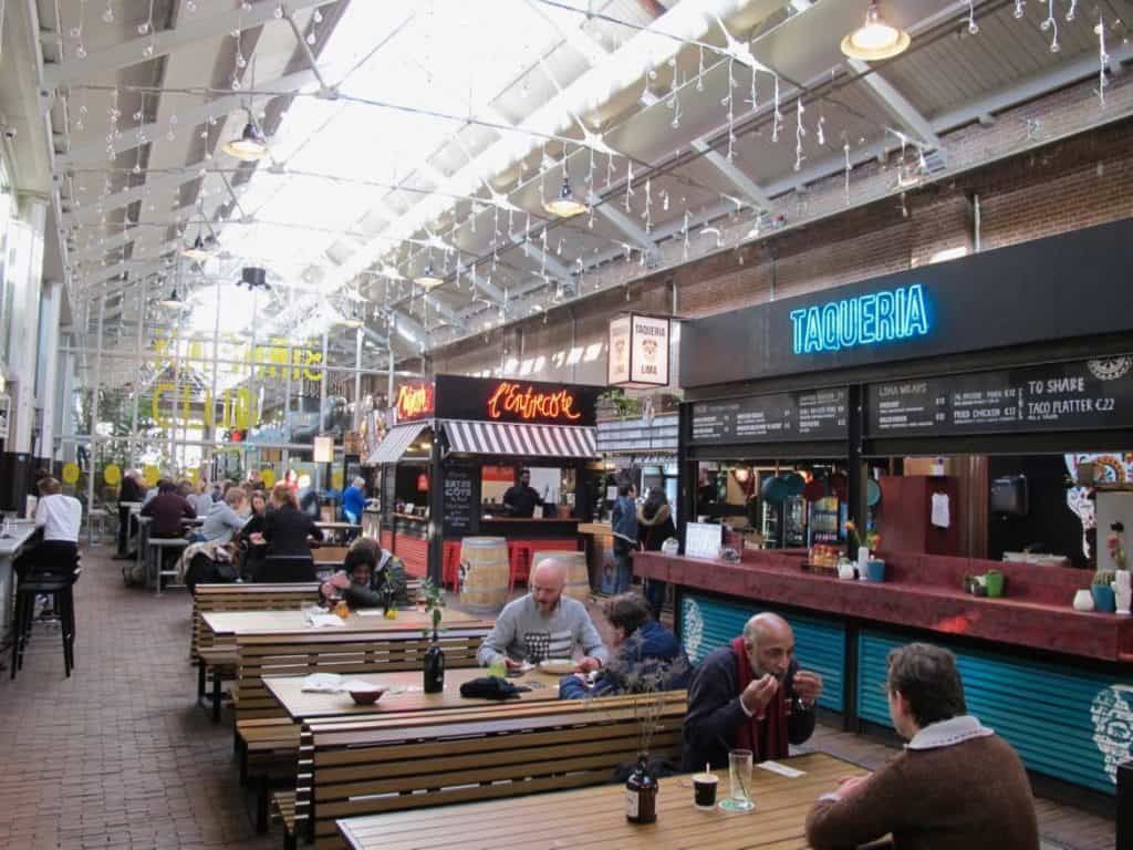
## Description De Hallen Foodhallen is one of Amsterdam’s most successful examples of adaptive reuse, turning a former tram depot into a vibrant indoor destination where food, design, and urban culture meet. Located in Amsterdam West, the complex blends a market atmosphere with a polished contemporary setting, so it feels both casual and curated. For food travelers, it is especially appealing because it concentrates many different flavors in one indoor space, making it easy to compare dishes, sample small plates, and settle in for a social meal without committing to a single restaurant. What makes Foodhallen so compelling is that it captures a distinctly Amsterdam approach to city life: practical, stylish, and communal without being overly formal. A lesser-known fact is that the building forms part of the wider De Hallen redevelopment, which transformed industrial infrastructure into a cultural and social hub with a cinema, library, boutiques, and creative spaces. Another detail worth noticing is how the setting changes the dining experience. Because the market is indoors and largely weatherproof, it works well year-round, which is a major advantage in a city where the climate can be unpredictable. The food itself is the main reason people come back. Instead of traditional market stalls with produce, Foodhallen offers a mix of street food and prepared dishes from different vendors, often ranging from Dutch comfort food to international plates and modern snacks. That diversity makes it useful for groups, because people with different tastes can all find something appealing. It is equally suitable for a solo traveler looking for a lively lunch as it is for a relaxed evening with friends. The atmosphere tends to be energetic but not chaotic, and the design of the hall gives the entire space a sense of urban polish. Another reason it ranks high with visitors is its location in a neighborhood that feels more local than postcard-touristy, yet still easy to reach. If you enjoy seeing how Amsterdam works outside the canal belt, De Hallen Foodhallen is one of the smartest stops to make. ## Location De Hallen Foodhallen is located inside the De Hallen complex in Amsterdam West, North Holland, Netherlands. The neighborhood sits a short distance from the historic center, which makes the venue easy to reach while still giving you a sense of a different side of the city. Amsterdam West is known for its residential streets, creative energy, and a more lived-in atmosphere than the most heavily visited central districts. The easiest way to get there is by tram, bike, or a short taxi ride from central Amsterdam. Public transport is typically the most convenient option for first-time visitors, and cycling can be a strong choice if you are comfortable navigating the city like a local. Once inside the complex, the Foodhallen is easy to find because it is one of the main anchor attractions. It is worth combining the visit with a broader look at De Hallen itself, especially if you are interested in architecture or urban regeneration. You can also use it as part of a neighborhood day out, exploring nearby streets, cafés, and shops before or after your meal. ## Tips Visit hungry but not starving. The venue is designed for sampling and sharing, so leaving some room for variety will make the experience more enjoyable. If you are with a group, agree on a general budget before ordering. The temptation to try several vendors can add up quickly, especially when drinks are included. Go at off-peak times if you want a calmer experience. Lunch and early evening can be lively, while late afternoons often offer a little more breathing room. Take your time choosing. The food hall format works best when you walk the full space first and compare what each vendor offers rather than committing immediately to the first appealing stall. Keep the visit flexible. De Hallen has more to offer than food alone, so leaving time for the broader complex makes the outing feel richer. ## Conclusion De Hallen Foodhallen is a polished and enjoyable Amsterdam food destination that balances variety, atmosphere, and design. Its indoor format, good location, and wide range of vendors make it an easy recommendation for travelers who want a lively meal in a memorable setting. ## FAQ ### Is De Hallen Foodhallen expensive? It can be mid-range to moderately expensive depending on what you order, but the variety makes it possible to eat well at different budgets. Small plates and sharing can help control costs. ### Is it good for families? Yes. The indoor setting, broad food selection, and casual environment make it suitable for families, especially when weather is poor or you want a relaxed place to eat together. ### Do I need reservations? Usually not for simply visiting the food hall, though some nearby venues or specific events may be different. If you plan to dine at a popular time, arriving earlier is a smart move. ### What is the best time to visit? Late lunch, early evening, or a quieter weekday visit often works well. The best time depends on whether you want a buzzing atmosphere or a more relaxed browsing experience. ## Links - [Foodhallen Amsterdam](https://foodhallen.nl/en/venues/amsterdam) - [De Hallen Amsterdam](https://dehallen-amsterdam.nl/en/)
GemVoyage Team • World
Brussels
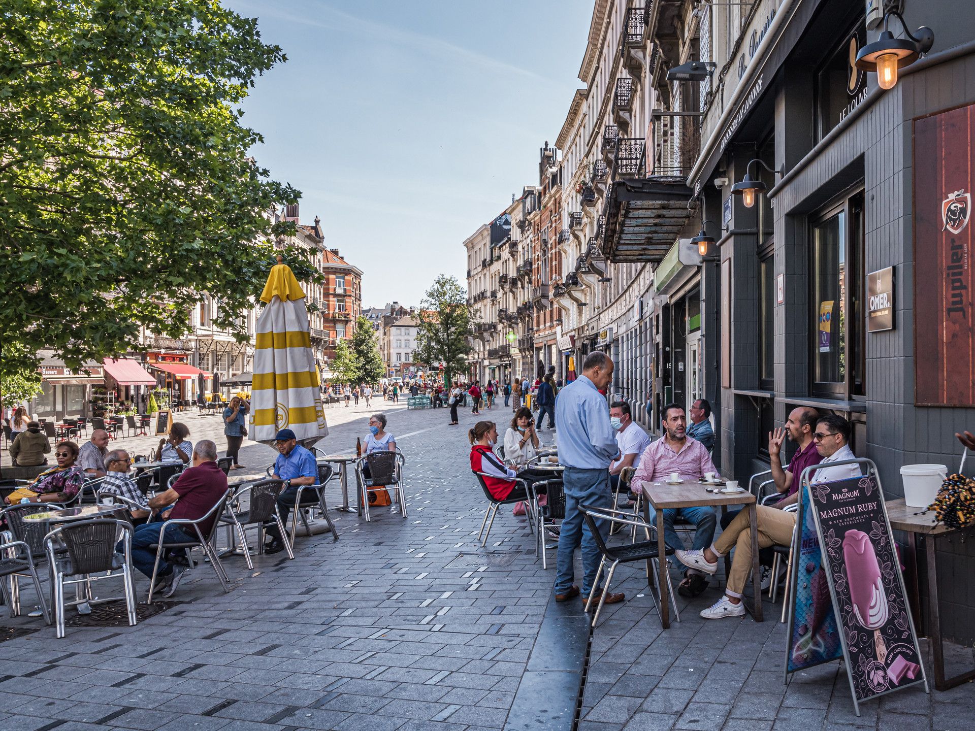
## Description Saint-Gilles is one of Brussels’ most interesting neighborhoods because it feels lived-in, creative, and slightly unruly in ways that make urban travel more rewarding. It is not a single attraction in the conventional sense. Instead, it is a district where architecture, cafés, local life, art spaces, and residential streets come together to form a strong neighborhood identity. For travelers who prefer walking through cities rather than just checking off monuments, Saint-Gilles offers exactly the kind of layered experience that makes Brussels memorable. The neighborhood stands out because it combines elegance and texture. You will find Art Nouveau and eclectic architecture, busy local streets, small shops, community energy, and a range of everyday scenes that make the area feel authentic rather than curated. A lesser-known fact is that Saint-Gilles has long attracted artists, creatives, and socially diverse residents, which helps explain its visual and cultural variety. Another detail many visitors notice is the way the neighborhood shifts from quiet residential blocks to more animated streets with cafés, bakeries, and independent businesses, creating a sequence of moods within a relatively compact area. For visitors, the appeal is that Saint-Gilles rewards wandering. You can walk without a strict plan and still encounter buildings worth noticing, neighborhood squares, and cafés that reflect local rhythm rather than generic tourism. The district also works well if you enjoy comparing Brussels neighborhoods, because it feels distinct from the more polished central commercial zones and from the quieter residential areas elsewhere in the city. Saint-Gilles is especially good for travelers who want a more grounded version of Brussels. It gives you a sense of people living, working, and socializing in ways that feel immediate and real. That quality is often more memorable than a single headline monument. ## Location Saint-Gilles is a municipality and neighborhood area in Brussels-Capital Region, Belgium, located just south of the city center. Its location makes it easy to reach from central Brussels while still feeling like a district with its own identity. Because it is connected to major transport corridors and adjacent neighborhoods, it works well as part of a broader walking itinerary. The easiest way to get there is by tram, metro, or on foot from central Brussels depending on your starting point. Many visitors find that a walk into Saint-Gilles helps the neighborhood reveal itself gradually. Once there, the streets are best explored slowly, with a mix of aimless wandering and a few concrete stops such as cafés, architectural highlights, or local squares. If you are planning a Brussels visit that includes multiple neighborhoods, Saint-Gilles fits well alongside Ixelles, the city center, or other south-side districts. ## Tips Walk without rushing. The neighborhood’s character comes from details in the street life and architecture. Look up at the façades. Saint-Gilles is one of the better Brussels districts for architectural variety. Stop at a local café or bakery. The neighborhood is best experienced through everyday routines as much as sightseeing. Be open to small discoveries. A side street or square may end up being more interesting than a famous landmark. Use it as a neighborhood day rather than a single-photo stop. The area rewards longer, slower exploration. ## Conclusion Saint-Gilles is one of Brussels’ most rewarding neighborhoods for travelers who like authentic city life, architecture, and walkable streets. It offers a strong sense of place that comes from everyday urban texture rather than one big attraction. ## FAQ ### Is Saint-Gilles worth visiting for tourists? Yes, especially if you enjoy neighborhoods with character, architecture, and a local feel rather than purely tourist-oriented sights. ### How long should I spend there? At least a couple of hours if you want to walk, stop for coffee, and notice the neighborhood properly. ### Is it easy to combine with other Brussels areas? Yes. It works well with the city center, Ixelles, and other nearby districts. ### What is the main reason to go? To experience a creative, lived-in part of Brussels that feels distinct from the more polished tourist core. ## Links - [Saint-Gilles on Wikipedia](https://en.wikipedia.org/wiki/Saint-Gilles,_Belgium)
GemVoyage Team • World
Zaragoza
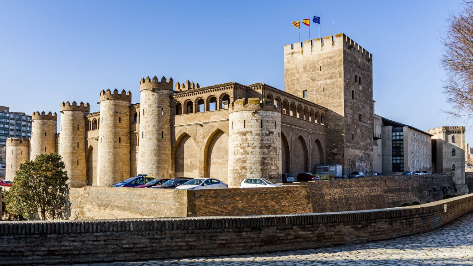
## Description The **Palacio de la Aljafería** is one of Spain’s most remarkable monuments, a living testimony to the country’s diverse cultural and architectural history. Built in the second half of the 11th century by the Muslim rulers of Zaragoza, the palace originally served as a fortified royal residence during the taifa kingdom period. Its delicate arches, intricate stucco work, and lush courtyards reflect the splendor of Islamic art at its peak in the Iberian Peninsula. What makes Aljafería unique is the way its history is layered within its walls. After the Christian conquest of Zaragoza in 1118, the palace was transformed into the residence of the Catholic monarchs, Ferdinand and Isabella, who added Renaissance elements while preserving much of the Islamic structure. Later, it served as a military barracks, and today it houses the regional parliament of Aragón. Few buildings in Spain embody such a continuous blend of Islamic, Christian, and modern political life. A little-known fact is that the palace inspired key architectural motifs in Spain’s most famous Moorish monument, the **Alhambra in Granada**. Another fascinating detail is that the palace appears in literature: it is the setting for *Las Cortes de la Muerte*, a play by Lope de Vega, reflecting its enduring cultural significance. ## Location The Aljafería Palace is located in **Zaragoza**, the capital of the **Aragón** region in northeastern **Spain**. The palace lies just west of Zaragoza’s city center, on Calle de los Diputados, about 20 minutes on foot from the Plaza del Pilar, where the Basilica of Our Lady of the Pillar stands. Visitors arriving by train to Zaragoza-Delicias station can reach the palace in around 10 minutes by bus or taxi. From Madrid or Barcelona, Zaragoza is easily accessible by high-speed AVE train in just over 1.5 hours, making the Aljafería an ideal stop for travelers exploring northern Spain. Walking or public transport is the best way to reach the palace once in the city. ## Tips * **Book in advance:** Entry is limited, and guided tours often sell out quickly, especially in peak tourist seasons. * **Take a guided tour:** Guides explain the symbolism of the Islamic decorations and the historical transitions that shaped the palace. * **Check opening hours:** The palace is closed on certain public holidays and has reduced hours in winter. * **Combine with other sites:** Pair your visit with the Basilica del Pilar and La Seo Cathedral for a full picture of Zaragoza’s religious and cultural heritage. * **Photography tip:** Morning light is best for photographing the courtyards and intricate arches. Flash photography inside is not permitted. * **Allow enough time:** Set aside at least 1.5–2 hours to fully enjoy the architecture, exhibitions, and gardens. ## Conclusion The **Aljafería Palace** is a masterpiece of Islamic architecture in Spain, later enriched with Christian and Renaissance elements. Its rich history, architectural beauty, and continued political role make it one of Zaragoza’s most important landmarks. For travelers seeking to understand Spain’s layered cultural identity, the Aljafería is an unmissable destination. ## FAQ **1. What is the Aljafería Palace best known for?** It is best known for its Islamic architecture from the taifa period, its later Christian additions, and its role as the seat of the Aragonese parliament. **2. How much time do I need to visit?** A thorough visit takes about 1.5 to 2 hours, especially if you join a guided tour. **3. Is the palace family-friendly?** Yes, the palace is suitable for families. Children often enjoy exploring its courtyards and fortress-like exterior. **4. Are guided tours available in English?** Yes, guided tours in English and other languages are available but should be booked in advance. **5. Is the palace included in UNESCO World Heritage?** The Aljafería itself is not individually listed, but it is part of the broader UNESCO designation of **Mudejar Architecture of Aragón**, recognized for its cultural significance. **6. Can I buy tickets online?** Yes, tickets can be purchased online through official Zaragoza or Aragón tourism websites. ## Links * [Official Tourism of Aragón – Aljafería Palace](https://www.turismodearagon.com) * [Zaragoza Tourism – Palacio de la Aljafería](https://www.zaragoza.es/turismo)
GemVoyage Team • World

Comments