Discover extraordinary places shared by our community of travelers
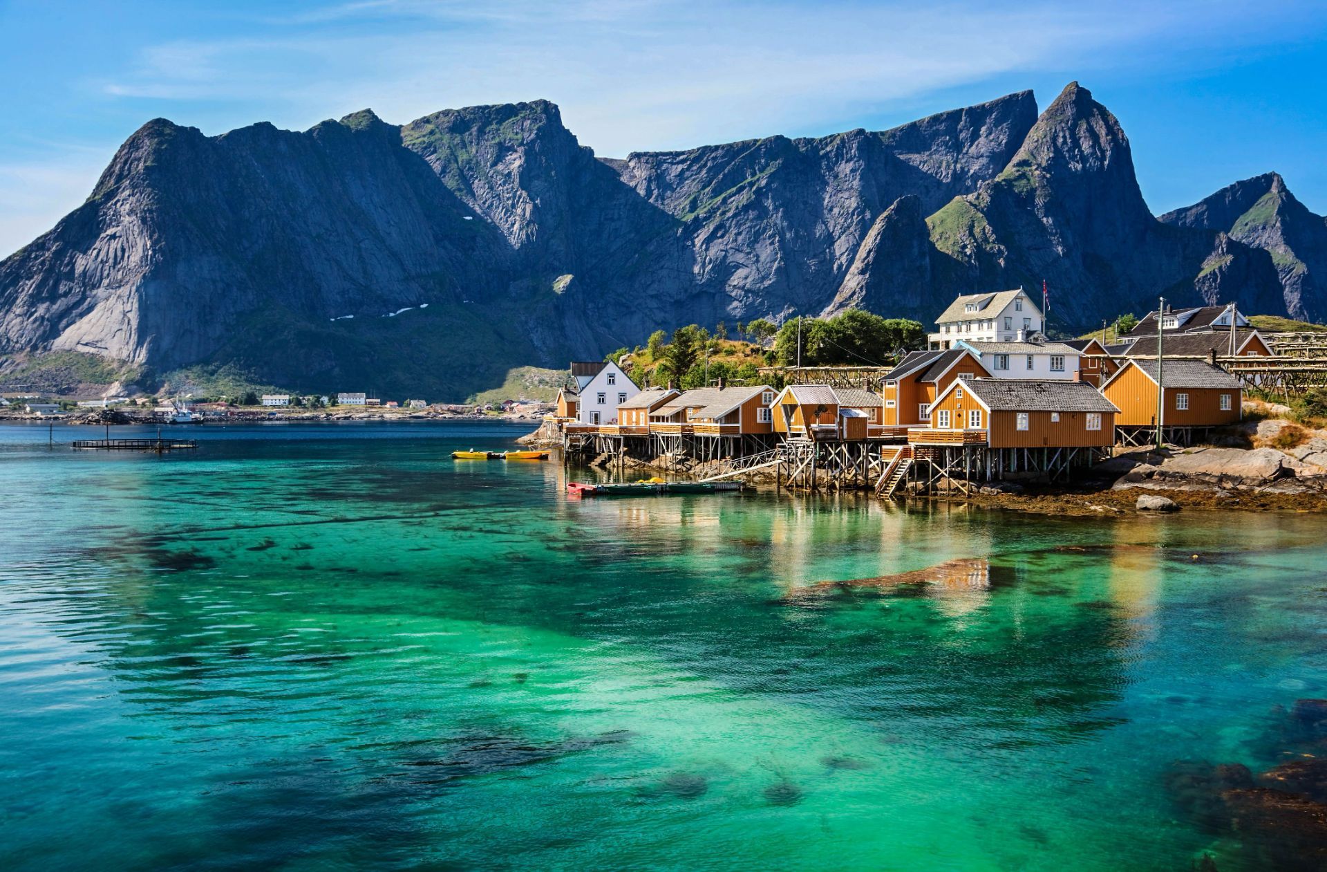
Nordland County
## Description The Lofoten archipelago in northern Norway is known for dramatic mountains rising directly from the sea, sheltered bays dotted with red rorbuer (fishermen’s cabins), and a culture shaped by the cod-fishing season. The islands’ jagged peaks, sheltered fjords and clear northern light create a playground for photographers, hikers and sailors. In summer the midnight sun bathes the landscape in continuous soft light; in winter the aurora borealis weaves curtains above snow-dusted fjords. Lofoten’s distinctiveness lies in the proximity of ocean and mountain: trails often ascend steep ridges that drop into crystal-clear water, and small fishing villages serve as intimate bases for outdoor activities. A lesser-known feature: the islands host significant seabird colonies and seasonal fisheries that have influenced local cuisine and traditions for centuries. Lofoten is not only a visual spectacle but also a destination that rewards slow travel and careful planning. The archipelago's human scale — low-lying villages, narrow winding roads and tiny harbors — means that experiences are tactile and immediate: you can start your day with fresh cod straight from a quay, follow a narrow trail to a windswept summit by afternoon, and end it watching the sea change color as the light shifts. For photographers and naturalists the islands offer a year-round curriculum: in spring and early summer, migrant birds and seals become active along the coastline; in high summer the midnight sun extends golden-hour conditions for long landscape sessions; in autumn the first snows highlight ridgelines and create vivid contrasts; and in winter the long nights are ideal for aurora hunting, provided the skies are clear and weather windows allow. Trail conditions vary widely: some classic hikes like Reinebringen and Kvalvika require stout footwear and a head for exposure, while many coastal walks are family-friendly and can be combined with ferry hops and short drives. Sea-based activities are equally compelling — kayaking through sheltered fjords, joining local fishing trips, or chartering a boat for wildlife watching. Local cultural experiences add texture: museums documenting the seasonal cod fisheries, small artisan shops selling wool and salt-dried fish, and community-run cafés where fishermen swap stories. Food culture in Lofoten remains rooted in the sea; besides stockfish and cod, you’ll encounter local sheep cheeses, cloudberry desserts and a surprisingly well-developed craft-beer scene in a few towns. Practicalities matter in Lofoten. Roads are scenic but narrow, and in winter they can be affected by snow and wind; a flexible itinerary is wise. While many visitors cluster in Reine and Svolvær, quieter pockets such as Henningsvær, Nusfjord and Vinstad reward those who linger. Conservation-minded travel is important: stay on marked trails, respect nesting birds (especially during spring), and support locally owned businesses. Small details like packing waterproof layers, carrying a reliable map or GPS, and learning a few Norwegian phrases will enhance safety and interpersonal encounters. Taken together, these elements make Lofoten an unforgettable destination where dramatic geology, maritime culture and luminous Arctic light combine into a deeply memorable travel experience. ## Location Lofoten lies within Nordland county, above the Arctic Circle, accessible by ferry, road and regional flights from Bodø and Harstad/Narvik airports. The main islands (Austvågøya, Vestvågøya, Flakstadøya and Moskenesøya) are linked by scenic roads and tunnels. The islands are most commonly reached via the E10 highway, which threads the archipelago and connects ferries and causeways. Travelers flying in usually connect through Bodø, which provides ferry and road links, or land at Evenes (near Harstad/Narvik) then drive west. Several regional ferries link the mainland with islands and provide excellent photo opportunities; during summer months additional tourist ferry routes and charter options operate between hotspots like Reine and Svolvær. Car rental is widely available in nearby towns and airports, but public transport is a viable option for those who prefer not to drive, with buses and select ferries serving the larger settlements. ## Tips - **Respect weather windows:** Mountain weather changes rapidly; check local forecasts and prepare with layers and navigation tools. - **Book rorbuer early in summer:** Traditional cabins are popular in high season; reserve in advance. - **Try cod-based cuisine:** Experience local dishes tied to the seasonal stockfish tradition. - **Plan photographic routes:** Sunrise, sunset, and aurora times are key for planning shots; local guides help find hidden vantage points. - **Pack for microclimates:** Conditions can vary from wind-blasted summits to calm fjord inlets in short distances; waterproof outer layers and thermal mid-layers are essential. - **Mind daylight hours:** In summer you can shoot at midnight; in winter plan activities around shorter daylight but prime aurora hours. - **Respect wildlife and nesting areas:** Keep distance from seabird colonies and seal haul-outs to avoid disturbance. - **Rent responsibly or use local guides:** Boat, kayak and fishing charters offer deeper access; choose operators with good safety and sustainability records. - **Bring cash for small purchases:** While cards are widely accepted, some small cafés and stalls may prefer cash in remote villages. ## Conclusion Lofoten combines raw Arctic scenery with a resilient maritime culture, offering dramatic outdoor adventures and timeless coastal charm. Whether you come for the light, the mountains, or the cultural textures of fishing villages, Lofoten rewards curiosity and careful pacing. The islands invite both active exploration and quiet observation — a place to test your kit on rugged trails or simply watch tides and light shift over a year of weathered harbor wood. For travelers prioritizing sustainable, small-scale tourism, Lofoten offers a rich palette of experiences that connect landscape, livelihood and seasonal rhythms. ## FAQ - **Q: When is the best time to visit?** - A: Summer for midnight sun and hiking; winter for northern lights and dramatic snow landscapes. - **Q: Are there guided activities?** - A: Yes — kayaking, hiking, fishing tours and wildlife excursions are widely available. - **Q: Do I need a car to enjoy Lofoten?** - A: A car gives flexibility for reaching remote viewpoints and dispersed villages; however, during summer a combination of buses, ferries and guided tours can cover many highlights without driving. - **Q: How do I plan for aurora viewing?** - A: Check local aurora forecasts and cloud cover, pick dark sites away from town lights, and be patient — clear sky windows are unpredictable. Local guides can increase success rates and handle safety in cold conditions. - **Q: Are trails family-friendly?** - A: Many shoreline walks and lowland trails are suitable for families; some iconic ridgeline hikes are steep and exposed and require good footwear and experience. - **Q: How should I handle food and provisioning?** - A: Larger towns have supermarkets and restaurants; in smaller villages, stockfish shops, local bakeries and seasonal markets offer regional specialties — plan ahead for long drives between services in peak season. ## Links - [Lofoten — Wikipedia](https://en.wikipedia.org/wiki/Lofoten)
GemVoyage Team • World
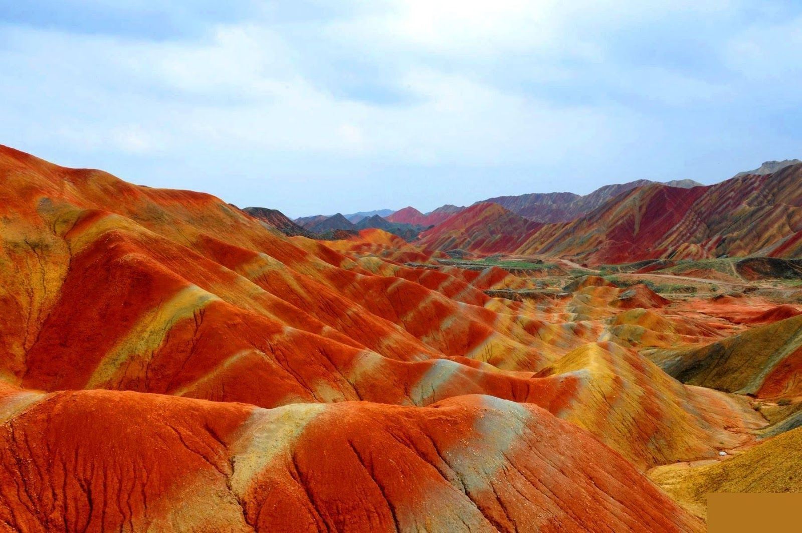
Gansu
## Description The Zhangye Danxia landform in Gansu province is a riot of color spread across layered sandstone ridges and steep cliffs, creating landscapes that look as if someone painted the earth with broad strokes of red, orange, yellow and green. The chromatic bands are the product of red sandstone and mineral deposits laid down over 24 million years and later uplifted and carved by wind and water. Viewed from purpose-built overlooks and winding boardwalks, the patterns create optical illusions of waves and folds that shift with the sun’s angle. The site is remarkable both for its vivid palette and for the scale of the striations: what from a distance seems like painted canvas resolves into a labyrinth of ridges, gullies and panoramic terraces. A lesser-known detail: the colors vary seasonally and with weather conditions; after rain, the hues often deepen, offering particularly saturated photographic opportunities. Beyond the immediate visual drama, Zhangye Danxia offers a lesson in geologic time and human-scale interpretation of landscape. The park's boardwalks and viewing platforms were designed to give visitors a range of compositions at different elevations, while interpretive signs explain the processes of sedimentation, uplift and erosion that produced the striking bands. Photographers and landscape enthusiasts often plan their visits around atmospheric conditions: low-angle light during golden hours casts ridges into sharp relief, while overcast or misty days can soften colors and emphasize shapes. The park's scale means that a single viewpoint never fully captures the variety present across the terrain — taking time to traverse multiple platforms yields a richer sense of the formations. Local infrastructure has expanded to accommodate steady tourism, but many visitors still find quiet corners along lesser-known paths. For those willing to explore beyond the main viewing decks, short hikes and rural lanes reveal unexpected perspectives of the painted cliffs and provide a quieter atmosphere for contemplative study. The town of Zhangye offers practical amenities including hotels, train connections and guided-tour services; most visitors access the geopark via a short drive from the city. When combined with nearby attractions in Gansu province — historic Silk Road sites, oasis towns and desert landscapes — Zhangye Danxia becomes a vivid and contrasting chapter in any northwest China itinerary. ## Location The Zhangye Danxia Geopark lies in Zhangye city, Gansu province, northwestern China. It’s accessible by road from Zhangye city center, which in turn connects by train or air to larger Chinese hubs such as Lanzhou and Xi’an. The park’s viewing platforms are designed for staged sightseeing, enabling visitors to experience different panoramas without extensive trekking. Timetables for trains and regional buses vary seasonally; many travelers arrive by high-speed or conventional rail to Zhangye and then take local shuttle services or taxis to the geopark entrance. The park's layout is linear, with a series of parking lots and platforms that correspond to different photographic viewpoints — plan logistics to avoid backtracking during peak hours. Accommodation in Zhangye ranges from economical guesthouses to mid-range hotels that can arrange guided excursions and private transport. ## Tips - **Visit at golden hour:** Sunrise or sunset gives the painted ridges warmer tones and dramatic shadows. - **Use multiple viewpoints:** Walk the main boardwalk and visit several overlooks to appreciate how the formations change with perspective. - **Protect from dust and sun:** The region is arid; bring sun protection and a dust cover for camera gear. - **Consider guided photo tours:** Local guides can take you to lesser-known vantage points for unique compositions. - **Time your transport:** Parking and shuttle flows can be busy; arrive early to avoid crowds at the main platforms. - **Dress for desert conditions:** Layered clothing, sturdy shoes and water are essential; evenings can cool significantly. - **Respect park rules:** Stay on boardwalks to protect fragile soils and prevent erosion; drones are often restricted. - **Bring varied lenses:** A wide-angle to capture panoramic ridgelines and a moderate telephoto to isolate patterns will be useful. ## Conclusion Zhangye Danxia offers one of the planet’s most vivid examples of sedimentary color and erosion, a landscape that rewards patient observation and thoughtful composition. Visiting Zhangye Danxia is as much an exercise in perception as it is in travel logistics — the colors and forms change with light, season and vantage point, and the most memorable experiences come when you slow down and let the terrain reveal its subtleties. For photographers, geologists and curious travelers, the geopark is a compelling and photogenic stop that pairs well with broader exploration of Gansu’s cultural and natural history. ## FAQ - **Q: Is the park walkable?** - A: Yes — well-maintained boardwalks and viewing platforms offer accessible scenic routes. - **Q: Can I drive between viewpoints?** - A: Internal park transport and short walks connect main viewpoints; check park maps for distances. - **Q: When is the best season for color saturation?** - A: Late spring through early autumn generally provides strong color contrast, but early morning light and post-rain conditions often produce the most saturated hues. - **Q: Are drones allowed for aerial photography?** - A: Drone policies vary and are often restricted near protected viewpoints — always check park regulations and obtain permits if required. - **Q: How much time should I allocate?** - A: A full half-day can cover the primary platforms; photographers might want a full day to cycle through light conditions and multiple viewpoints. - **Q: What other nearby sites pair well with Zhangye Danxia?** - A: Historic Silk Road towns, the Mati Temple Grottoes and desert landscapes around Zhangye make for complementary cultural and geological explorations. ## Links - [Zhangye Danxia — Wikipedia](https://en.wikipedia.org/wiki/Zhangye_National_Geopark)
GemVoyage Team • World
